 Explore
 Shop
Shop About
About Search
Overview Index
Ferrari World
24.483239°, 54.607439° - Abu Dhabi, United Arab EmiratesFerrari World is an amusement park located on Yas Island in Abu Dhabi, United Arab Emirates. Covering 86,000 square meters, it claims to be the world’s largest indoor theme park and contains "Formula Rossa" - the world's fastest roller coaster.
Maxar Technologies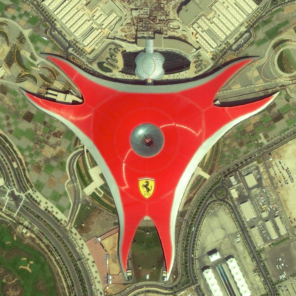
Friedenau
52.471692°, 13.328281° - Berlin, GermanyFriedenau is a neighborhood in the southwestern suburbs of Berlin, Germany. The streets and squares of Friedenau are laid out in a geometric urban design known as a Carstenn Figure. This type of plan is characterized by a circular road that is divided by central avenue.
Maxar Technologies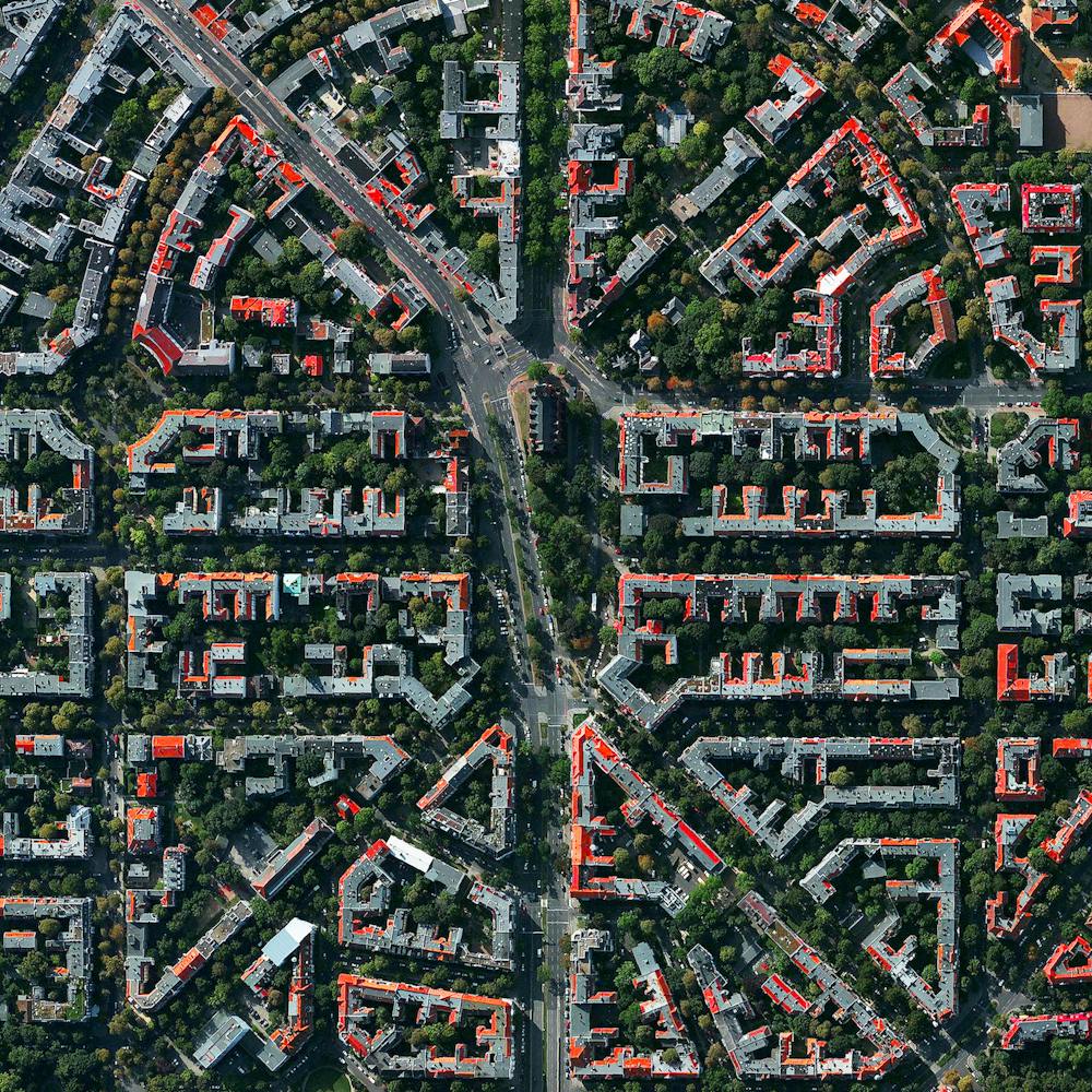
Gardens of Versailles
48.808056°, 2.108333° - Versailles, FranceThe Gardens of Versailles are situated across 2,000 acres of land behind the Palace of Versailles, 19 kilometers (12 miles) outside of Paris. The grounds are landscaped in the classic French garden style, including one section known as The Orangerie - an area seen here at the upper right that contains more than one thousand (primarily orange) trees.
Maxar Technologies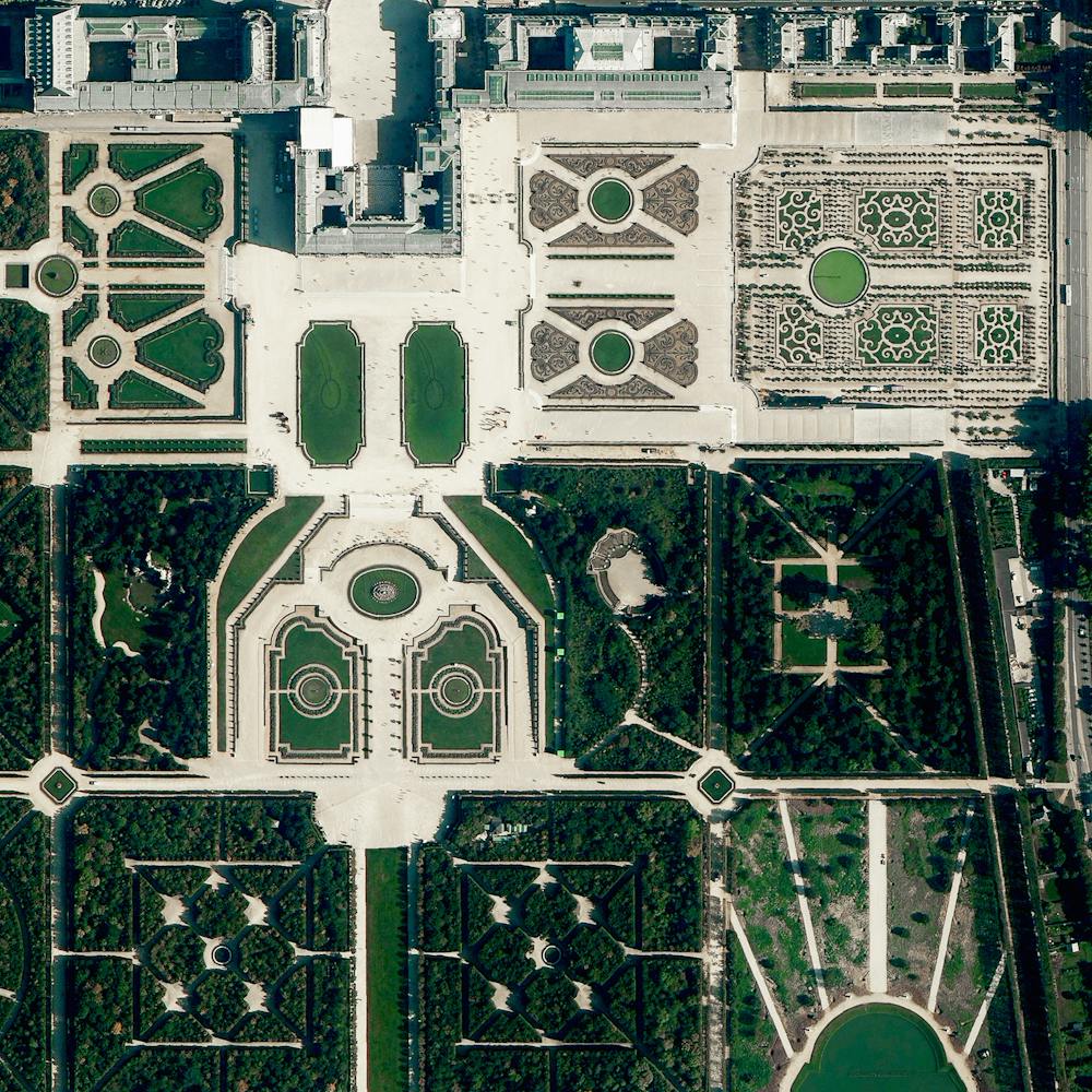
Golden Gate Bridge
37.819907°, -122.478558° - San Francisco, California, USAThe Golden Gate Bridge is a 1.7 mile long suspension bridge in San Francisco, California that spans the Golden Gate Strait, the mile-wide channel between San Francisco Bay and the Pacific Ocean. The bridge’s signature color, known as “international orange”, was selected to complement its natural surroundings and enhance its visibility in fog.
Nearmap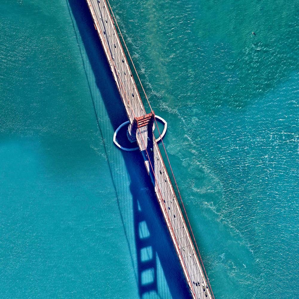
Great Pyramids of Giza
29.979234°, 31.134201° - Cairo, EgyptThe Great Pyramids of Giza are located on the outskirts of Cairo, Egypt. Dating back to 2580 BC, the Great Pyramid, the largest structure at the site, is the oldest of the Seven Wonders of the Ancient world and the only one to remain largely intact. With an estimated 2,300,000 stone blocks weighing from 2 to 30 tons each, the 481 foot pyramid was the tallest structure in the world for more than 3,800 years.
Maxar Technologies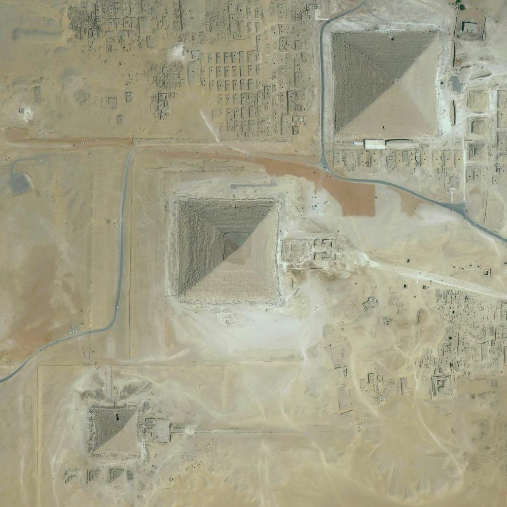
Het Loo Palace
52.234167°, 5.945833° - Apeldoom, NetherlandsHet Loo Palace is located in Apeldoorn, Netherlands. “The Great Garden,” situated behind the residence, follows the general Baroque landscape design formula: perfect symmetry, axial layout with radiating gravel walks, parterres with fountains, basins, and statues.
Maxar Technologies
Hoover Dam
36.015844°, -114.738804° - Arizona / Nevada, USAHoover Dam is a 221-meter-high (726-foot), 379-meter (1,244-foot) concrete arch-gravity dam, located on the Colorado River at the border of Arizona and Nevada, USA. Constructed between 1931 and 1936 during the Great Depression, a workforce of approximately 20,000 poured a total of 3.33 million cubic meters (4.36 million cubic yards) of concrete to complete the structure – enough to pave a two-lane highway from San Francisco to New York City.
Nearmap
Incheon Bridge
37.414274°, 126.572495° - Incheon, South KoreaIncheon Bridge is a cable-stayed bridge that stretches 21.4 kilometers (13.3 miles) from Yeongjong Island to the mainland of Incheon in South Korea. The structure’s central tower (what makes the bridge “cable-stayed”) was the most challenging part to construct with a height of 230.5 meters (756.2 ft) and a vertical clearance of 74 meters (243 ft). The entire project cost more than two billion dollars (three billion Korean won) to complete.
Maxar Technologies
Jiangsu Province Bagua
31.647722°, 119.533556° - Jiangsu Province, ChinaAn earth-formed Bagua arrangement is pictured amid the shallow waters of Changdang Lake, in China’s Jiangsu Province. An important symbol in Taoist cosmology, the Bagua consists of a yin-yang surrounded by eight sets of three-line patterns. This particular arrangement, known as “Later Heaven,” is symbolic of achieving balance and accepting change as time passes.
Maxar Technologies
Judge Harry Pregerson Interchange
33.928917°, -118.280583° - Los Angeles, California, USAThe Judge Harry Pregerson Interchange is a 130-foot-tall (40 m) stack interchange near the Athens and Watts communities of Los Angeles, California. It is formed by the intersection of Interstate 105 (Glenn M. Anderson Freeway) and Interstate 110 (Harbor Freeway). For a full weekend in 2015, one of the interchange ramps was closed for filming the opening musical number of “La La Land.”
Nearmap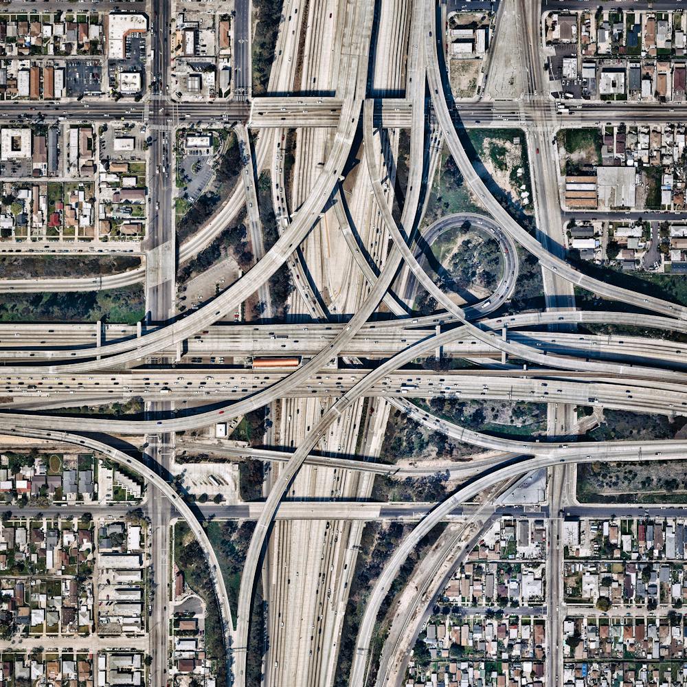
Juscelino Kubitschek Bridge
-15.823611°, -47.829444° - Brasilia, BrazilThe Juscelino Kubitschek Bridge is a steel and concrete structure that crosses Lake Paranoá in Brasília, Brazil. The main span has four supporting pillars submerged underwater, while the deck weight is supported by three 200-foot-tall (61 m) asymmetrical steel arches that crisscross diagonally over the bridge.
Maxar Technologies
Karlsruhe, Germany
49.009167°, 8.403889° - Karlsruhe, GermanyThe city of Karlsruhe, Germany was planned with a palace tower at its center, surrounded by 32 radiating streets. Because the design resembled the ribs of a folding fan, the city is sometimes called the “fan city” or “Fächerstadt." Additionally, this city's urban plan gave rise to the geometry concept of “Karlsruhe Metric” which refers to a measure of distance that assumes travel is only possible along radial streets and along circular avenues around the center.
Maxar Technologies
La Plata
-34.921111°, -57.954444° - -34.921111°, -57.954444°The planned city of La Plata — the capital city of the Province of Buenos Aires, Argentina — is characterized by its strict, square grid pattern. At the 1889 World’s Fair in Paris, the new city was awarded two gold medals in the categories “City of the Future” and “Better Performance Built.” La Plata has a population of around 765,000 people.
Maxar Technologies
Louvre Museum
48.860854°, 2.335812° - Paris, FranceA river cruise passes by the Louvre Museum in Paris, France. Located on the Seine River, the Louvre is the world’s most visited museum, receiving more than nine million visitors per year. The entrance to the museum, seen at the top and center of this Overview is a glass and metal pyramid, designed by architect I.M. Pei. Visitors enter through the pyramid, descend into the spacious lobby, and then re-ascend into the wings of the museum.
Maxar Technologies
Louvre Pyramid
48.858951°, 2.277020° - Paris, FranceThe Louvre Pyramid in Paris, France, was designed by Chinese-American architect I.M. Pei, who passed away yesterday at the age of 102. The structure, which consists exclusively of glass segments and metal poles, reaches a height of 71 feet (21.6 m) and has a square base with 112-foot-long (34 m) sides. While the pyramid is often recognized as Pei’s most famous design, his firm’s other works include the Rock and Roll Hall of Fame in Cleveland, Ohio, and the Museum of Islamic Art in Doha, Qatar.
Geomni Maps
Maggie Daley Park
41.882500°, -87.618889° - Chicago, Illinois, USAThis Overview shows Maggie Daley Park in Chicago, Illinois, USA. The park’s Buckingham Fountain stands out in this Overview with its ornate design and serve as a gathering point for thousands of visitors at the yearly Lollapalooza festival.
Maxar Technologies
Marabe Al Dhafra
23.611166°, 53.706629° - Abu Dhabi, United Arab EmiratesThe villas of Marabe Al Dhafra in Abu Dhabi, United Arab Emirates are home to approximately 2,000 people. The yearly average temperature in Abu Dhabi is slightly greater than 94 degrees Fahrenheit (34.5 degrees Celsius).
Maxar Technologies
McMurdo Station
-77.840119°, 166.644358° - Ross Island, AntarcticaMcMurdo Station is a United States research center on the southern tip of Ross Island in Antarctica. It is one of three U.S. Antarctic science facilities and the largest community on the continent, capable of supporting 1,258 residents. It boasts a harbor, three airfields, a heliport, more than 100 buildings, and Antarctica’s only two ATMs.
Maxar Technologies
Melbourne Skeleton Mural
-37.711934°, 144.992803° - Melbourne, AustraliaA mural of a pink skeleton covers the grounds at Reservoir Skatepark in northern Melbourne, Australia. This piece spans roughly 20,000 square feet (1,858 sq. m) and is one of many large murals in the area created by local artist Kitt Bennett. For a sense of scale, 20,000 square feet is nearly half the size of an American football field.
Nearmap
Melrose Park
-32.016664°, 69.955090° - Fort Lauderdale, Florida, USAMelrose Park is a residential community in Fort Lauderdale, Florida, USA. The neighborhood is planned with streets in eight concentric octagons and contains 1,975 households.
Maxar Technologies
Mischief Reef
9.916667°, 115.533333° - Spratly Islands, South China SeaThe New York Times published a fascinating piece this morning on Chinese island building in the South China Sea. Dredgers - the boats you see here around "Mischief Reef" - pump sediment from the ocean up into floating pipes, and deposit the material onto the reef to increase land area. This enables the large-scale construction projects currently underway on the newly formed islands. See the full story .
Maxar Technologies
Mont Saint-Michel
48.636111°, -1.511389° - Normandy, FranceMont Saint-Michel is a commune located one kilometer off the coast of Normandy, France. Over the past 600 years, the island has functioned as a prominent monastery (accessible to pilgrims only during low tide), a French fortification that withstood England attacks during the Hundred Years’ War, and a prison. Today, Saint-Michel is one of the most popular tourist attractions in the country.
Maxar Technologies
Montauk Point Light
41.070961°, -71.856708° - Montauk, New York, USAMontauk Point Light is a lighthouse located at the easternmost point of Long Island in the hamlet of Montauk, New York. With its construction authorized by George Washington in April 1792, the building was the first of its kind in New York and is the fourth oldest active lighthouse in the United States.
Maxar Technologies
Montreal Stadium
45.558000°, -73.552000° - Montreal, CanadaOlympic Stadium in Montreal, Canada was constructed for the 1976 Olympic Games. The stadium is home to the city's soccer and football teams and also features the world's largest inclined tower (574 feet). Hope all of our followers in Canada had a wonderful Canada Day yesterday!
Maxar Technologies
Mount Calvary Cemetery
40.633694°, -74.235028° - Linden, New Jersey, USAMount Calvary Cemetery is a cemetery in Linden, New Jersey, belonging to the St. Adalbert Roman Catholic Church. Saint Adalbert (Wojciech) is the patron saint of Poland and thus an important figure for many living in the city of Linden. More than 13% of residents there are of Polish origin and 15.6% of residents primarily speak Polish at home.
Nearmap
Museum of Pop Culture
47.621500°, -122.348611° - Seattle, Washington, USAThe Museum of Pop Culture (also known as MoPOP) is a nonprofit museum in Seattle, Washington, dedicated to contemporary popular culture. Founded in 2000, it contains exhibits on fantasy, horror cinema, video games, science fiction, music and more. The museum’s unique, 140,000-square-foot (13,000 sq. meter) structure was designed by architect Frank Gehry.
Nearmap
Naarden
52.300000°, 5.166667° - Naarden, NetherlandsNaarden is a star fort in the Netherlands. The city was constructed in the manner seen here so that an attack on any individual wall could be defended from the two adjacent star points by shooting at the enemy from behind. Today Naarden is home to roughly 17,000 residents.
Maxar Technologies
Nardò Ring
40.327222°, 17.826111° - Nardò, ItalyThe Nardò Ring is a high speed, 7.8 mile long, circular test track in Nardò, Italy. Each of the ring’s four lanes has a determined “neutral speed” and is banked in such a manner that one can drive as if the road were straight.
Maxar Technologies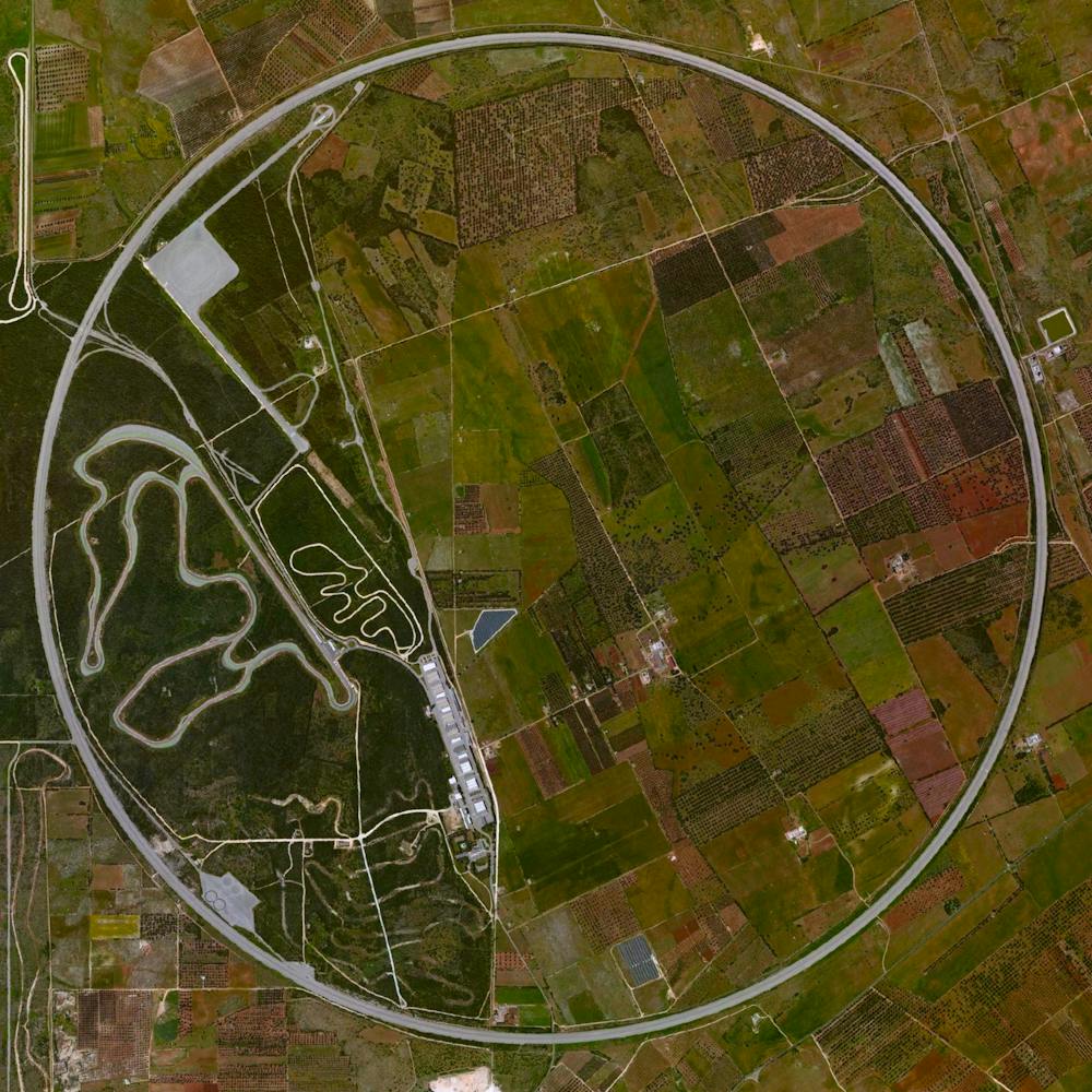
New Century Global Center
30.572222°, 104.060833° - Chengdu, ChinaThis morning I’ll fly to Chengdu, China. The city is home to the recently constructed New Century Global Center - a multipurpose facility that contains numerous shopping malls, an IMAX cinema, a “mediterranean village," a pirate ship, a skating rink, and a 500x130 foot screen that displays artificial sunrises and sunsets. The structure contains the largest amount of floor space for a single building with approximately 18 million square feet.
Maxar Technologies
New Delhi
28.615593°, 77.209023° - Delhi, IndiaNew Delhi serves as the capital of India and is home to more than 21 million residents in its metro area. Officially inaugurated in February 1931, the city was planned by British architects Sir Edwin Lutyens and Sir Herbert Baker. Their design centered around two promenades - the Rajpath and the Janpath - that run perpendicular to each other and intersect here at center.
Maxar Technologies