Overview Index
Igauzu Falls
-25.695306°, -54.436735° - Argentina / BrazilIguazu Falls, the largest waterfall system in the world, is located on the border of Argentina and Brazil. Approximately half of the Iguazu River flows into a long and narrow chasm called the Devil's Throat — the u-shaped falls seen here at left — that is roughly 700 meters (2,297 ft) high. The total number of waterfalls at Igauzu fluctuates between from 150 to 300, depending on the water level.
Maxar Technologies
Ile de Noirmoutier Salt Pans
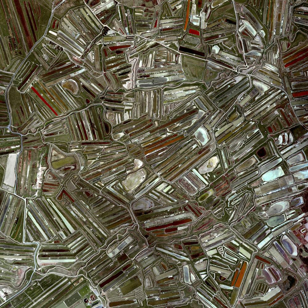
46.999512°, -2.282612° - Ile de Noirmoutier, FranceSalt pans are visible on Ile de Noirmoutier, an island off the coast of France. Here, more than 800 tonnes of salt are extracted annually through evaporation. Sea water is channeled into the basins via canals, which pass through reservoirs that get progressively shallower. Over time, evaporation causes the salt to crystallize and it is then carefully extracted from the pans.
Maxar Technologies
Incheon Bridge
37.414274°, 126.572495° - Incheon, South KoreaIncheon Bridge is a cable-stayed bridge that stretches 21.4 kilometers (13.3 miles) from Yeongjong Island to the mainland of Incheon in South Korea. The structure’s central tower (what makes the bridge “cable-stayed”) was the most challenging part to construct with a height of 230.5 meters (756.2 ft) and a vertical clearance of 74 meters (243 ft). The entire project cost more than two billion dollars (three billion Korean won) to complete.
Maxar Technologies
Incheon International Airport
37.463333°, 126.440000° - Incheon, South KoreaIncheon International Airport is located thirty miles west of Seoul, South Korea. The airport is one of the busiest in the world (23rd by annual passenger traffic at 47+ million) and also one of the most efficient. Airport authorities claim that the average departure and arrival at Incheon take only 19 minutes and 12 minutes, respectively. These times are significantly lower than the international average of 60 minutes for departures and 45 minutes for arrivals.
Maxar Technologies
Industrial buildings
33.740293°, -118.031207° - Westminster, California, USAIndustrial buildings cover approximately one square mile in Westminster, a city in the Los Angeles metropolitan area of California, USA. The complex includes numerous warehouses, a roller skating rink, and multiple engineering facilities.
Maxar Technologies
Inman Yard
33.795750°, -84.444583° - Atlanta, Georgia, USAFreight train cars, casting long shadows, are seen in at Inman Yard in Atlanta, Georgia, USA. The facility is operated by Norfolk Southern and serves as one of the major freight hubs on its network that extends for more than 36,000 miles in the United States.
Nearmap
Interchange construction
33.462551°, -112.426634° - Avondale, Arizona, USAAn interchange is constructed around the Pagano Freeway in Avondale, Arizona, USA. On average, an American motorist will pay approximately $171/year in road maintenance taxes.
Maxar Technologies
Intrepid Sea, Air & Space Museum
40.764889°, -74.000472° - New York City, New York, USAThe Intrepid Sea, Air & Space Museum is an American maritime and military history museum located on Pier 86 in New York City. Opened in 1982, the museum features the USS Intrepid aircraft carrier, the USS Growler submarine, a Lockheed A-12 supersonic reconnaissance plane, the Space Shuttle Enterprise, and many more aircraft.
Nearmap
Iōjima
30.790833°, 130.278596° - Kagoshima, JapanIōjima is an island located 59 miles (110 km) south of Kagoshima, Japan. Iōjima experiences frequent volcanic activity, which results in massive amounts of sulfur dioxide flowing into the sea. This causes the surrounding waters to turn yellow, green, and teal as seen here. The island has a total area of 4.5 miles (11.65 sq km) and a population of 142 persons.
Maxar Technologies
Ipanema Beach
-22.983611°, -43.204444° - Rio de Janeiro, BrazilAll of the exciting coverage at the Olympics has us thinking of this beautiful Overview of Ipanema Beach in Rio de Janeiro! Frequently recognized as one of the most beautiful beaches in the world, its 2.25 miles of sand are divided into segments by lifeguard towers known as "postos.”
Maxar Technologies
Iron Ore Mine Tailings Pond
46.407676°, -87.530954° - Negaunee, Michigan, USATailings are the waste and by-products generated by mining operations. The tailings seen here were pumped into the Gribbens Basin, next to the Empire and Tilden Iron Ore Mines in Negaunee, Michigan, USA. Once the materials are pumped into the pond, they are mixed with water to create a sloppy form of mud known as slurry. The slurry is then pumped through magnetic separation chambers to extract usable ore and increase the mine’s total output. For a sense of scale, this Overview shows approximately 2.5 square kilometers (1 square mile) of the basin.
Maxar Technologies
Island Walk
26.251389°, -81.710250° - Naples, Florida, USAThe Island Walk neighborhood in Naples, Florida, is home to slightly more than 3,000 people. Since many cities in the state of Florida contain master-planned communities — often built on top of waterways in the latter half of the twentieth century — a number of intricate designs like this one are visible from the Overview perspective.
Nearmap
Istanbul at night
41.007964°, 28.969139° - Istanbul, TurkeyIstanbul is the largest metropolitan area in Turkey, with a population of more than 14 million people. This Overview was captured at night from the International Space Station.
NASA
Istanbul Shipyard
40.837223°, 29.276616° - Istanbul, TurkeyThe Istanbul Shipyard offers facilities to build or repair fourteen large sea-faring vessels simultaneously. The complex contains cranes that have a lifting capacity of 550 tons as well as the largest drydock in Turkey - stretching more than one thousand feet (310 meters).
Maxar Technologies
Itaipu Reservoir
-22.959186°, -43.047163° - Brazil / ParaguayAgricultural fields line the shores of the Itaipu Reservoir — a body of water that forms the border between Brazil and Paraguay. The area’s tropical climate makes it an ideal place to grow sugarcane, coffee, tea, and cotton.
Maxar Technologies
Itaipu Reservoir
-25.305628°, -54.420162° - Brazil / ParaguayAgricultural fields line the shores of the Itaipu Reservoir—a body of water that forms the border between Brazil and Paraguay. The area’s tropical climate makes it an ideal place to grow sugarcane, coffee, tea, and cotton.
Maxar Technologies
Jacksonville Turbine Interchange
30.253056°, -81.516194° - Jacksonville, Florida, USAA turbine interchange connects the SR 9A and SR 202 in Jacksonville, Florida, USA. Also known as a whirlpool interchange, this structure consists of left-turning ramps sweeping around a center interchange, thereby creating a spiral pattern of right-hand traffic. This type of junction is rarely built, due to the vast amount land that is required to construct the sweeping roads.
Maxar Technologies
James Bay
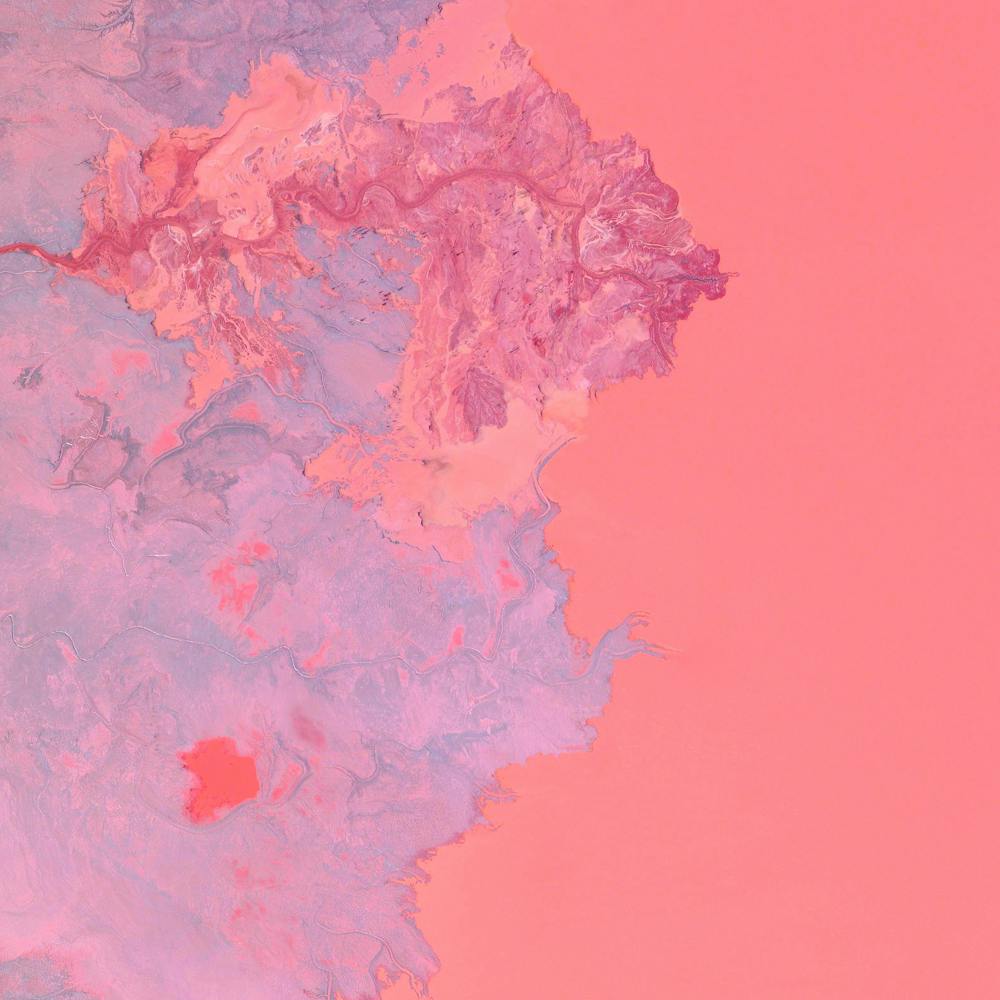
52.777778°, -81.933444° - Ontario, CanadaA tributary of the Attawapiskat River drains into James Bay in northeastern Ontario, Canada. James Bay is a body of water within Hudson Bay, which extends south from the Arctic Ocean. Human presence along the shores of the bay can be traced back to the end of the last ice age roughly 8,150 years ago, and a number of Aboriginal communities remain there today.
Maxar Technologies
Jebel Kissu
21.571389°, 25.132778° - 21.571389°, 25.132778°Jebel Kissu is a massif (a compact group of mountains) located in northwestern Sudan. It rises roughly 5,630 feet (1,716 m) above sea level, emerging abruptly like an island in the vast Sahara Desert. The bright linear features seen here are truck tracks — common in the Sahara where there are no paved roads.
United States Geological Survey
Jeongwang-dong
37.336147°, 126.718587° - Ansan, South KoreaJeongwang-dong is an industrial sector in the city of Ansan, South Korea. The Korean government intensively drove a plan to develop the modern city, particularly in this area, with an emphasis on manufacturing. The striking blue color that you see here results from the use of aluminum roofing, which is used for its low cost and longevity.
Maxar Technologies
Jiangsu Province Bagua
31.647722°, 119.533556° - Jiangsu Province, ChinaAn earth-formed Bagua arrangement is pictured amid the shallow waters of Changdang Lake, in China’s Jiangsu Province. An important symbol in Taoist cosmology, the Bagua consists of a yin-yang surrounded by eight sets of three-line patterns. This particular arrangement, known as “Later Heaven,” is symbolic of achieving balance and accepting change as time passes.
Maxar Technologies
Jodhpur
26.297840°, 73.018420° - Jodhpur, IndiaJodhpur, India, is home to more than one million residents, making it the second largest city in the state of Rajasthan. Jodhpur is often referred to as the “Blue City” due to the vivid, painted houses that can be seen throughout its urban area.
Maxar Technologies
Jökulsarlón
64.075167°, -16.243444° - IcelandJökulsarlón — or “glacial river lagoon” in English — is a large glacial lake in southeastern Iceland. Located next to the massive Vatnajökull glacier, the lagoon is formed as chunks of glacial ice melt before meeting the Atlantic Ocean. Sixty years ago, when the glacier reached all the way to the shore, Jökulsárlón did not exist; but since the 1970s it has more than quadrupled in size.
Maxar Technologies
Jönköping
57.782778°, 14.160556° - Jönköping, SwedenJönköping is a city in southern Sweden with roughly 94,000 inhabitants. It is situated at the southern end of Vättern, Sweden's second largest lake. Our founder Benjamin Grant is currently traveling there and two other towns at the southern end of Vättern to speak and meet with students. He will visit Jönköping University, the town of Hjo, and will do an exhibition of prints in collaboration with Uponwalls in the harbor in Granvik.
Maxar Technologies
Judge Harry Pregerson Interchange
33.928917°, -118.280583° - Los Angeles, California, USAThe Judge Harry Pregerson Interchange is a 130-foot-tall (40 m) stack interchange near the Athens and Watts communities of Los Angeles, California. It is formed by the intersection of Interstate 105 (Glenn M. Anderson Freeway) and Interstate 110 (Harbor Freeway). For a full weekend in 2015, one of the interchange ramps was closed for filming the opening musical number of “La La Land.”
Nearmap
Jurua River
-2.635833°, -65.756111° - -2.635833°, -65.756111°The Juruá River is a southern tributary of the Amazon River, flowing approximately 1,500 miles (2,400 km) through Brazil and Peru. For most of its length, the river winds through the Amazon basin and is generally curvy and sluggish.
Planet
Juscelino Kubitschek Bridge
-15.823611°, -47.829444° - Brasilia, BrazilThe Juscelino Kubitschek Bridge is a steel and concrete structure that crosses Lake Paranoá in Brasília, Brazil. The main span has four supporting pillars submerged underwater, while the deck weight is supported by three 200-foot-tall (61 m) asymmetrical steel arches that crisscross diagonally over the bridge.
Maxar Technologies
Jwaneng Diamond Mine
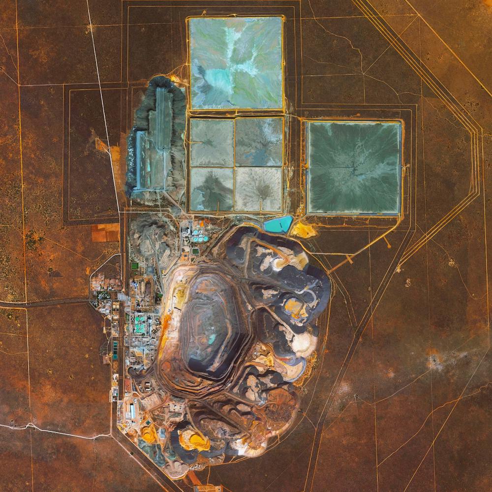
-24.523050°, 24.699750° - BostwanaThe Jwaneng Diamond Mine in Botswana is the richest diamond mine in the world, with an annual output of approximately 15.6 million carats. Mine richness takes into account the rate of diamond extraction combined with the quality of the diamonds that are mined (sale price per weight). To extract the diamonds, the facility produces 9.3 million tonnes of ore and an additional 37 million tonnes of waste rock per year.
Maxar Technologies
Kansai International Airport (KIX)
-32.016664°, 69.955090° - Osaka Bay, JapanKansai International Airport is located on an artificial island in the middle of Osaka Bay, Japan. To create the island, a 30 meter (98-foot) layer of earth was created on top of the seafloor with 21 million cubic meters of landfill. The material was excavated from three separate mountains. As of 2008, the total cost of Kansai Airport was $20 billion USD, including land reclamation that has been necessary to prevent its continued sinkage (7.1 centimeters per year as of 2008) into the bay.
Maxar Technologies
Karlsruhe, Germany
49.009167°, 8.403889° - Karlsruhe, GermanyThe city of Karlsruhe, Germany was planned with a palace tower at its center, surrounded by 32 radiating streets. Because the design resembled the ribs of a folding fan, the city is sometimes called the “fan city” or “Fächerstadt." Additionally, this city's urban plan gave rise to the geometry concept of “Karlsruhe Metric” which refers to a measure of distance that assumes travel is only possible along radial streets and along circular avenues around the center.
Maxar Technologies