Explore
 Shop
Shop About
About Search
Overview Index
Chino Airport Retired Airplanes
33.975160°, -117.635251° - San Bernardino County, California, USAA variety of retired aircraft sit on display at Chino Airport in San Bernardino County, California. The airport played an important role during World War II when it housed the Cal-Aero Academy, a flight training school for Army Air Cadets. After the war, hundreds of combat aircraft were brought to Chino for disposal; but many have been restored by two on-site aircraft museums — the Planes of Fame and the Yanks Air Museum.
Nearmap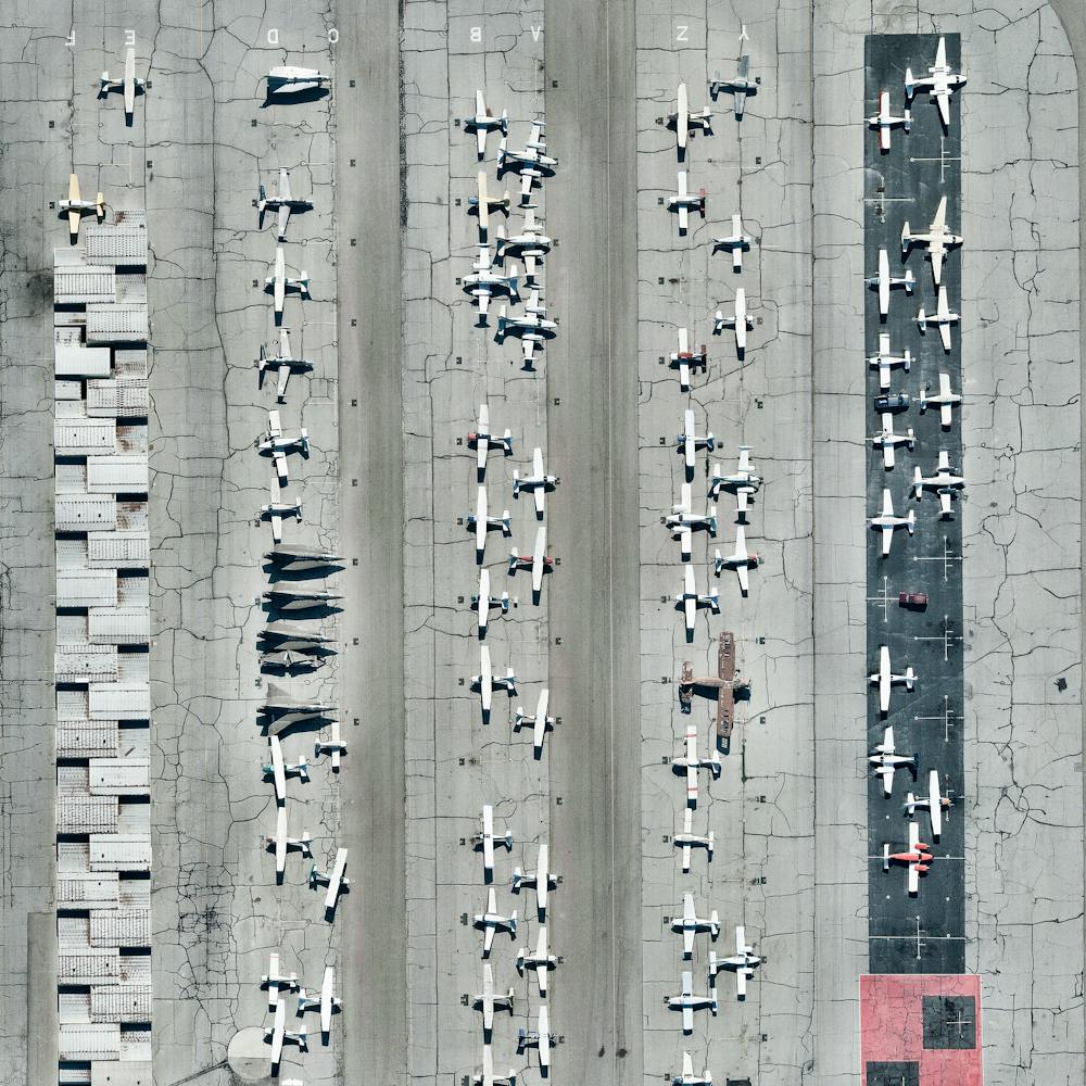
Chino, California Dairy Farm
33.989611°, -117.647222° - Chino, California, USAA herd of cows is ushered into a milking parlor on a dairy farm in Chino, California. For years, Chino was a center of dairy farming in Southern California, providing milk products to much of the southwestern United States. The industry peaked in the 1980s, when Chino and its surrounding areas had more than 400 dairies; today only a few remain.
Nearmap
Chongqing
29.558333°, 106.566667° - Chongqing, ChinaChongqing is a major city in southwest China with an urban population of nearly 8.2 million. Located along the Jialing (left) and Yangtze (right) Rivers, it serves as one of the most important inland ports in China. Numerous luxury cruise ships terminate at Chongqing, and coal, raw materials and containerized goods also pass through the city aboard cargo ships.
Maxar Technologies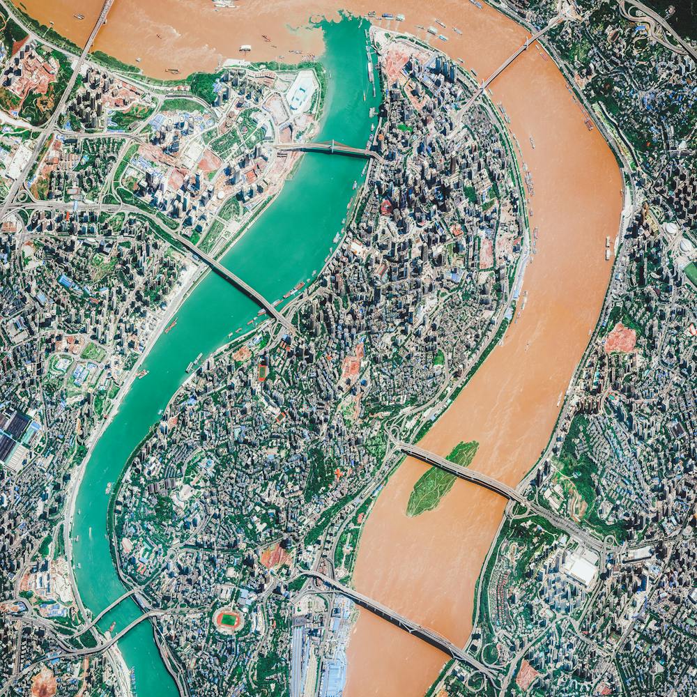
Cimetière Parisien de Pantin
48.904842°, 2.410054° - Paris, FranceCimetière parisien de Pantin is the largest cemetery in Paris, France, both in number of graves and land area. Since opening in November 1886, more than one million people have been buried here, with nearly 5,000 interments taking place each year. Pantin is a garden-style burial ground, with more than 8,000 trees and a network of 20 miles (32 km) of roads that allow motor vehicle access.
Geomni Map Pros
Circuit
43.250556°, 5.791667° - Le Castellet, FranceCircuit Paul Ricard is a motorsport track at Le Castellet, near Marseille, France. The track is known for its distinctive black and blue runoff areas called the Blue Zone. Additional deeper run-off areas known as the Red Zone use a more abrasive surface designed to maximize tire grip and minimize braking distance.
Maxar Technologies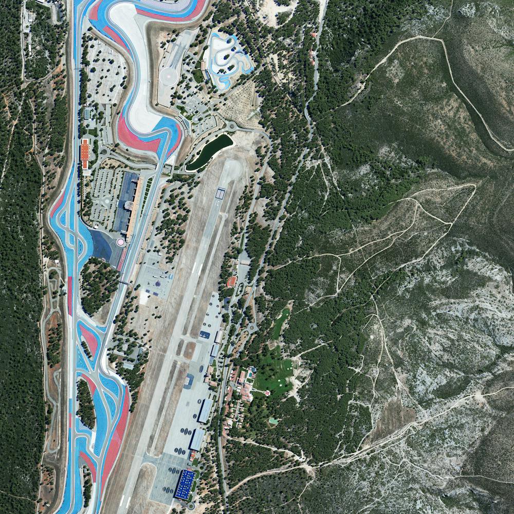
Citrus Trees
37.241139°, -7.294472° - Isla Cristina, SpainCitrus trees cover the landscape like fingerprints in Isla Cristina, Spain. The climate in this region is ideal for the growth of this produce with an average temperature of 64 degrees (18° celsius) and a relative humidity between 60% and 80%.
Maxar Technologies
Ciudad Nezahualcóyotl
19.400000°, -98.988889° - Mexico City, MexicoThis Overview captures the tightly gridded streets of Nezahualcóyotl, a municipality of Mexico City. With a population of more than one million (all of Mexico City contains approximately nine million), the area is home to many of the capital’s citizens who have migrated there from other parts of the country.
Maxar Technologies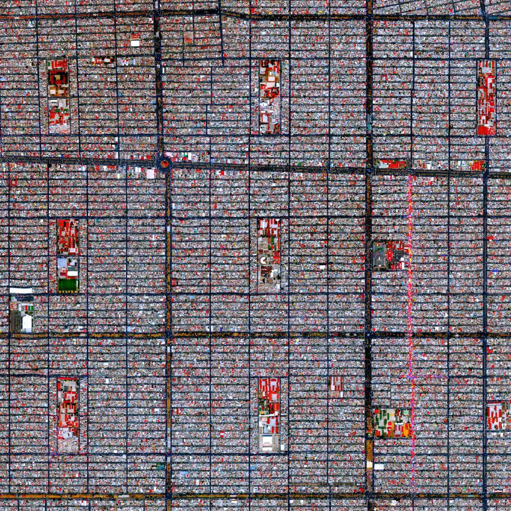
Clear Island Waters
-28.044500°, 153.397611° - Gold Coast, Queensland, AustraliaClear Island Waters is a suburb on the Gold Coast in Queensland, Australia. Built around artificial canals, it is a residential community that is home to roughly 4,000 people. Clear Island Waters is just a few miles west of Mermaid Beach, one of many beaches along the Gold Coast's 43-mile coastline.
Nearmap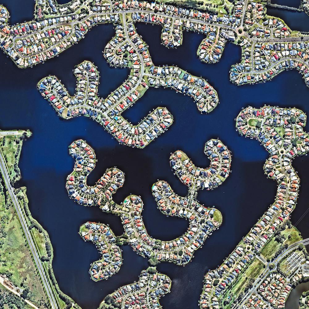
Cleveland Volcano Eruption
52.821694°, -169.946667° - Aleutian Islands, Alaska, USACheck out this incredible shot, which shows the eruption of Cleveland Volcano in Alaska’s Aleutian Islands. It was captured in May 2006 by an Expedition 13 crew member aboard the International Space Station. Mount Cleveland is one of the most active volcanoes in the Aleutian Arc, having erupted an estimated 22 times in the last 230 years.
NASA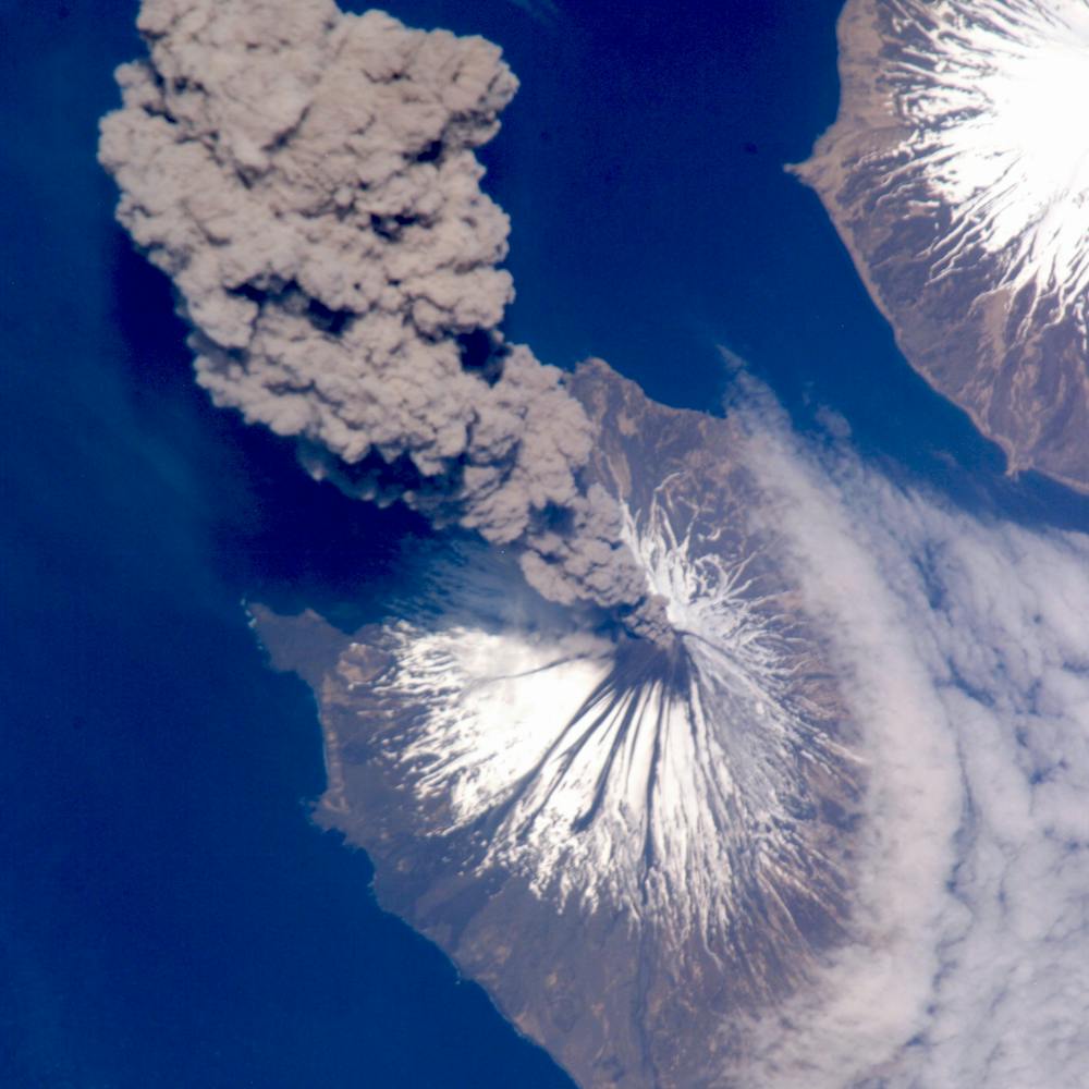
Cloverleaf interchange
25.174690°, 51.326337° - Doha, QatarA cloverleaf interchange is constructed on the outskirts of Doha, Qatar. The objective of a cloverleaf is to allow two highways to cross without the need to stop traffic.
Maxar Technologies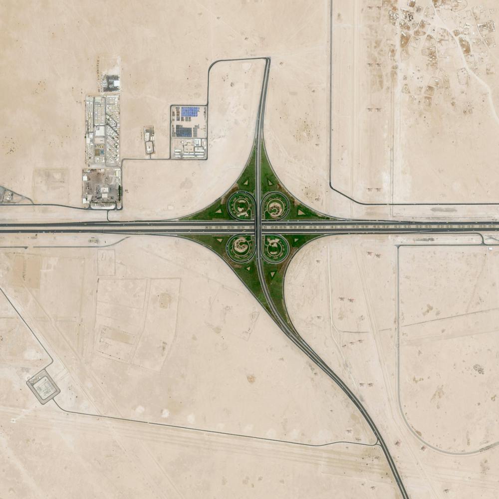
Cloverleaf Interchange
42.848854°, -85.678458° - Grand Rapids, Michigan, USAA cloverleaf interchange is formed at the intersection of U.S. Route 131 and the Paul B. Henry Freeway in Grand Rapids, Michigan, USA. Safe travels to everyone who will be out on the roads this weekend for the holiday!
Maxar Technologies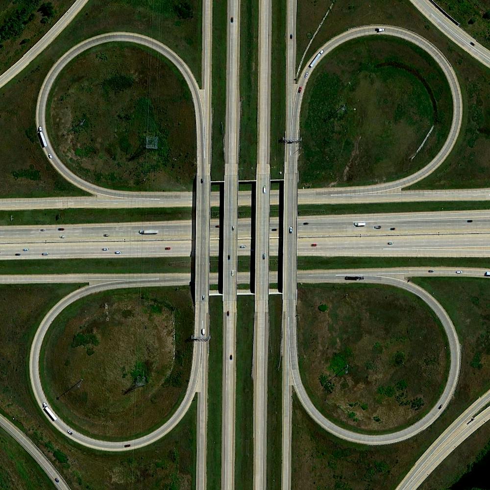
Coal trains
42.082523°, -102.890046° - Alliance, Nebraska, USACoal trains - some full, others empty - idle in a railyard next to a pivot irrigation circle in Alliance, Nebraska, USA. The city is located in the Powder River Basin - one of the world’s largest coal-mining areas - and serves as a stopping point for trains en route to power plants in the Midwest and Southern parts of the country.
Maxar Technologies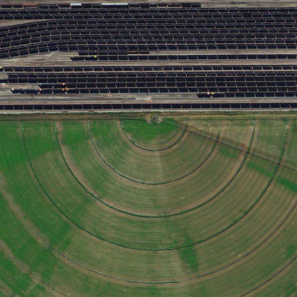
Coal Trains in Alliance, Nebraska
42.082523°, -102.890045° - 42.082523°, -102.890045°Coal trains — some full, others empty — idle in a railyard next to a pivot irrigation circle in Alliance, Nebraska, USA. The city is located in the Powder River Basin — one of the world’s largest coal-mining areas — and serves as a stopping point for trains en route to power plants in the Midwest and Southern parts of the country.
Maxar Technologies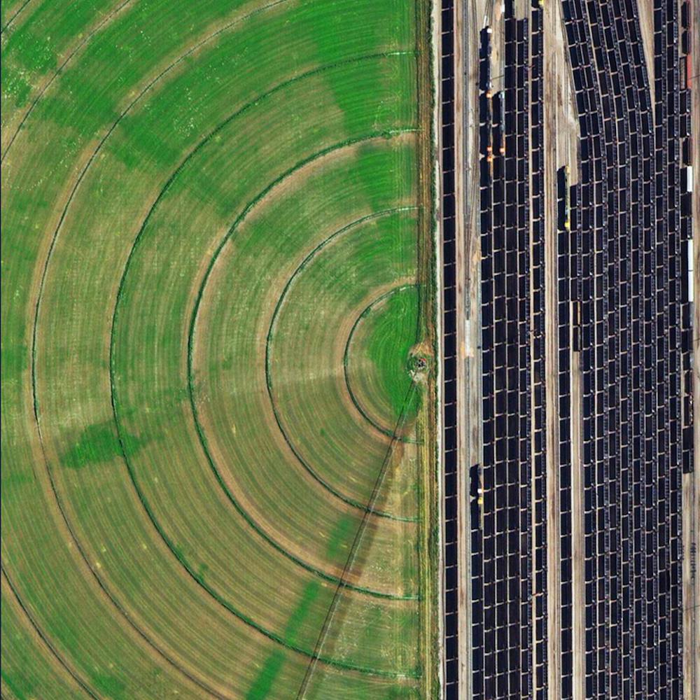
Colorado Farmland Patterns
40.986808°, -103.121749° - Logan County, Colorado, USACheck out this Overview, which shows some interesting patterns of farmland in Logan County, Colorado. Much of the county's 1,845 square miles (4,780 sq. km) is used for farming, ranching or related activities, making it one of the most productive agricultural counties in the state. Shown in the bottom half of this image is the small town of Peetz, which has more wind turbines (300) than residents (238).
Maxar Technologies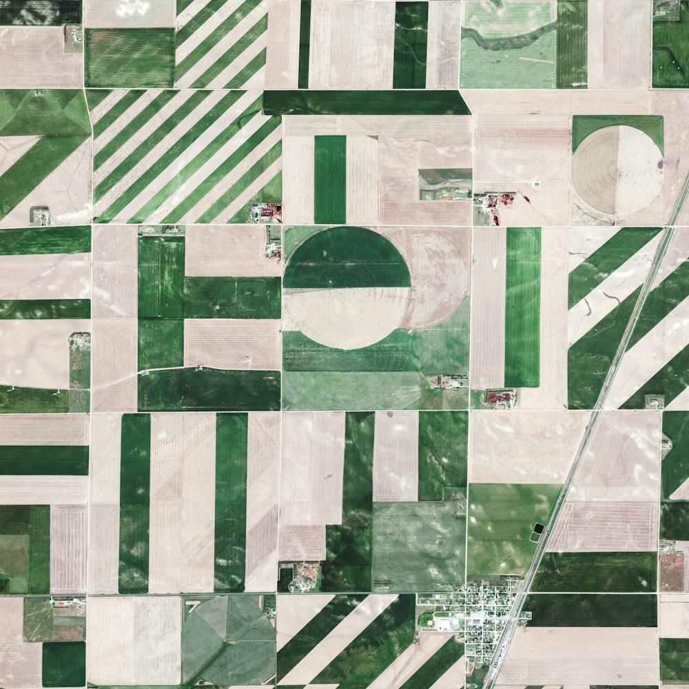
Commencement Bay Parasail
47.277111°, -122.452750° - Tacoma, Washington, USAA parasail is pulled behind a motorboat on Commencement Bay, just offshore Tacoma, Washington. Average water temperatures here can drop below 45 degrees Fahrenheit (7°C) in January and February, and often do not rise above 55 degrees Fahrenheit (12.7°C) in summer months.
Nearmap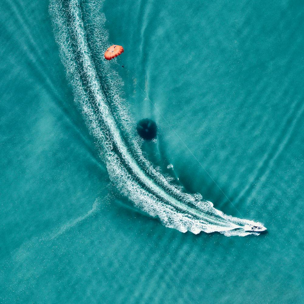
Copenhagen Kastellet
55.691417°, 12.595528° - Copenhagen, DenmarkKastellet — or “The Citadel” in English — is a star fortress located in Copenhagen, Denmark. It was built in October 1664 as part of a continuous ring of star forts surrounding the city, and it remains one of the best preserved ramparts of its kind in Northern Europe. Kastellet still houses some Danish military operations today, though it primarily serves as a public park and historic site.
Maxar Technologies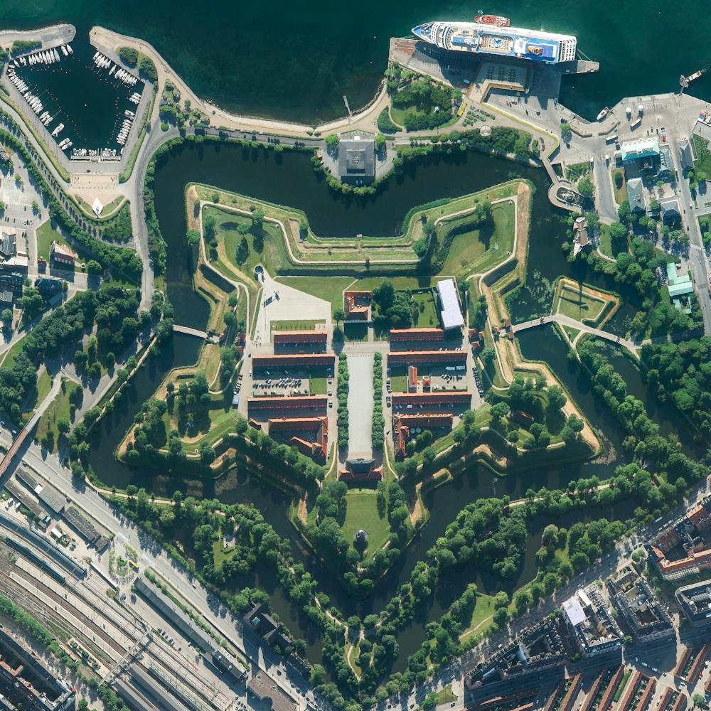
Corpus Christi Oil Refinery
27.833444°, -97.524750° - Corpus Christi, Texas, USACheck out this Overview, which shows a maze of pipes and other equipment at an oil refinery in Corpus Christi, Texas. Due to its position on the Port of Corpus Christi — the fifth largest U.S. port and deepest inshore port on the Gulf of Mexico — much of the city’s economy is driven by the oil and petrochemicals industry. An average of 400,000 barrels of crude oil per day were exported from this port during 2018.
Nearmap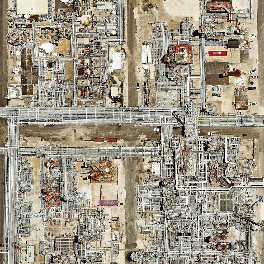
Cranberry Bogs
41.914292°, -70.792761° - Plymouth, Massachusetts, USAIf you put cranberries on your Thanksgiving turkey today, there’s a chance they came from these bogs in Plymouth, Massachusetts, USA. Cranberries are a Native American wetland fruit that are grown on low-lying vines, floating in beds of water layered with sand, peat, gravel, and clay. Coincidentally, the town of Plymouth is also the site of the colony founded by the Pilgrims in 1620 and was the home to the first Thanksgiving feast in 1621. Happy Thanksgiving from Daily Overview!
Maxar Technologies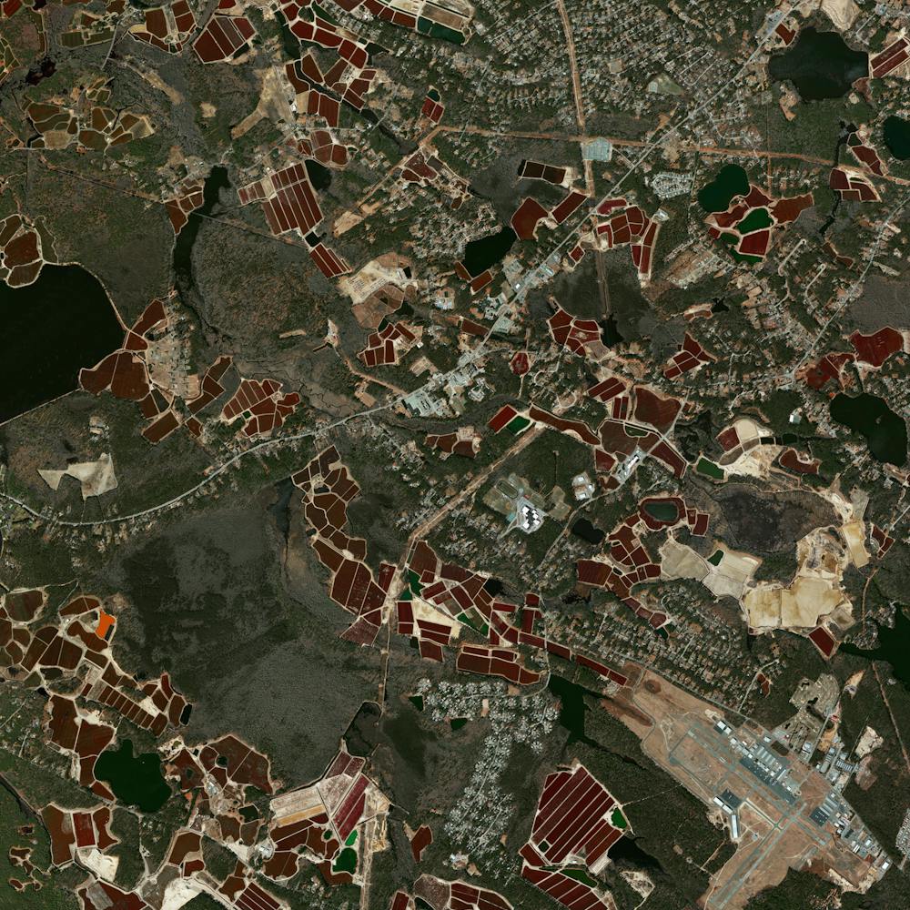
Crater Lake
42.950000°, -122.100000° - Klamath County, Oregon, USAMy favorite destination on this trip was Crater Lake in Oregon. The lake's awe-inspiring, deep blue water sits in a crater that was formed 7,700 years ago by the collapse of a volcano. Rain and snowfall compensate for any evaporation as no rivers flow into or out of the crater. At 1,943 feet (592 m), the lake is the deepest in the United States. Happy Independence Day from Daily Overview!
Maxar Technologies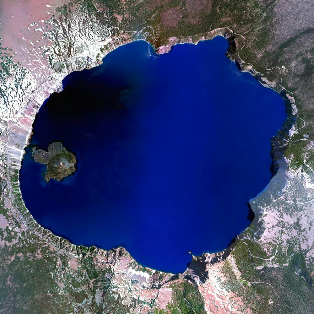
Crescent Dunes Solar Energy Project
38.238972°, -117.363721° - Tonopah, Nevada, USAThe Crescent Dunes Solar Energy Project near Tonopah, Nevada powers up to 75,000 homes during peak electricity periods. So how does it work? The project uses 17,500 heliostat mirrors to collect and focus the sun’s thermal energy to heat molten salt flowing through a 540-foot (160 m) tall solar power tower. The molten salt then circulates from the tower to a storage tank where it is used to produce steam and generate electricity. One last thing - look closely at the lower left corner of this Overview and you’ll see an airplane flying over the complex!
Maxar Technologies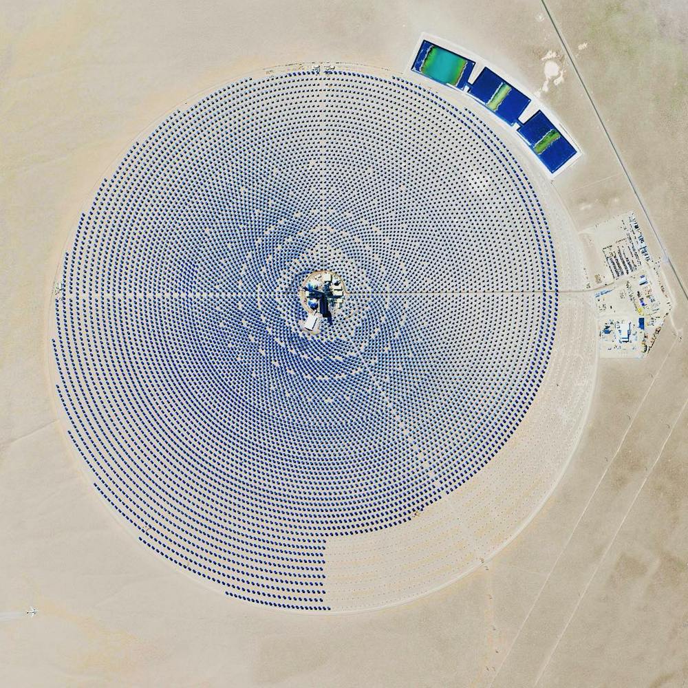
Crete Plasticulture
35.033793°, 25.694451° - CretePlastic greenhouses cover a stretch of shoreline on the south coast of Crete — the largest and most populous of the Greek islands. Inside these greenhouses, which cover an area of roughly 6 square miles (15 sq. km), large quantities of fruits and vegetables are grown for export. In the upper right corner of this Overview is the Bramiana Reservoir, which was built in 1986 to meet the needs of the thousands of greenhouses surrounding it.
Maxar Technologies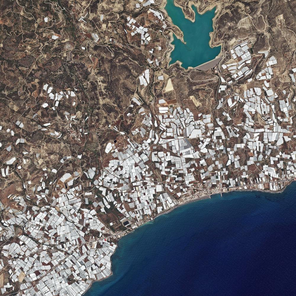
Cuajone Mine
-17.060772°, -70.729159° - Peruvian Andes, PeruThe Cuajone Mine is located near the district of Torata, in the southern range of the Peruvian Andes. The mine is best known for its copper deposits, but it other materials such as silver, zinc, and molybdenum have been extracted there as well. Operations began in 1970, and by 2009 accounted for 16% of the country's copper production.
Maxar Technologies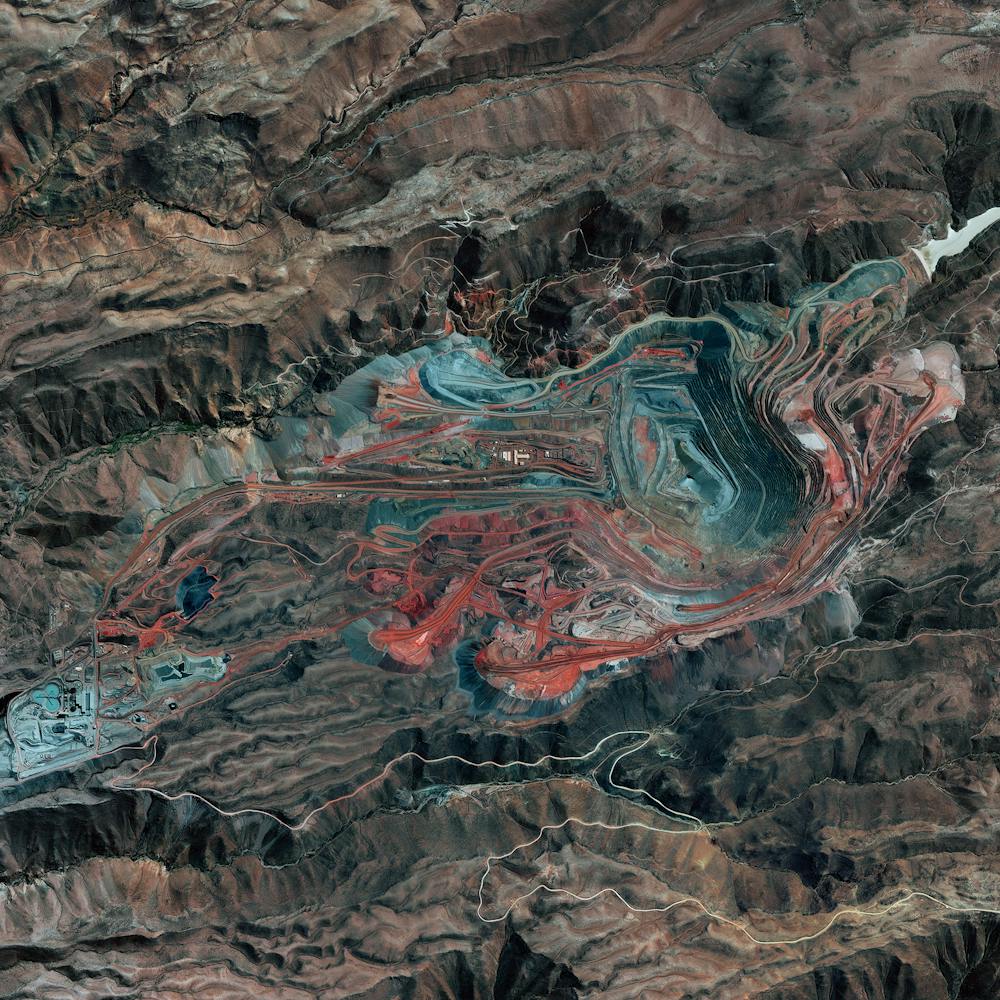
Cyclone Idai
-18.771924°, 42.371307° - MadagascarOver the past week, Cyclone Idai has wreaked havoc on countries in eastern Africa, causing strong winds and severe flooding in Madagascar, Mozambique, Malawi and Zimbabwe. This image, captured by the European Space Agency's Copernicus Sentinel-3 satellite, shows the cyclone on March 13 off the west coast of Madagascar. Hundreds of people have been killed in the disaster, and thousands more are stranded or missing.
ESA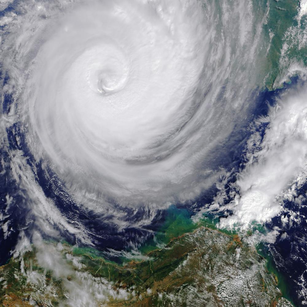
Cypress Village
33.691889°, -117.759139° - Irvine, California, USAUniform apartment buildings are seen here at Cypress Village, a township in Irvine, California. As a master-planned city, Irvine contains dozens of communities like this — each one having houses of a similar design, along with commercial centers, religious institutions, and schools. Irvine is one of the wealthiest cities in the western United States, with a median household income of $90,743 and a median home value of $784,500.
Nearmap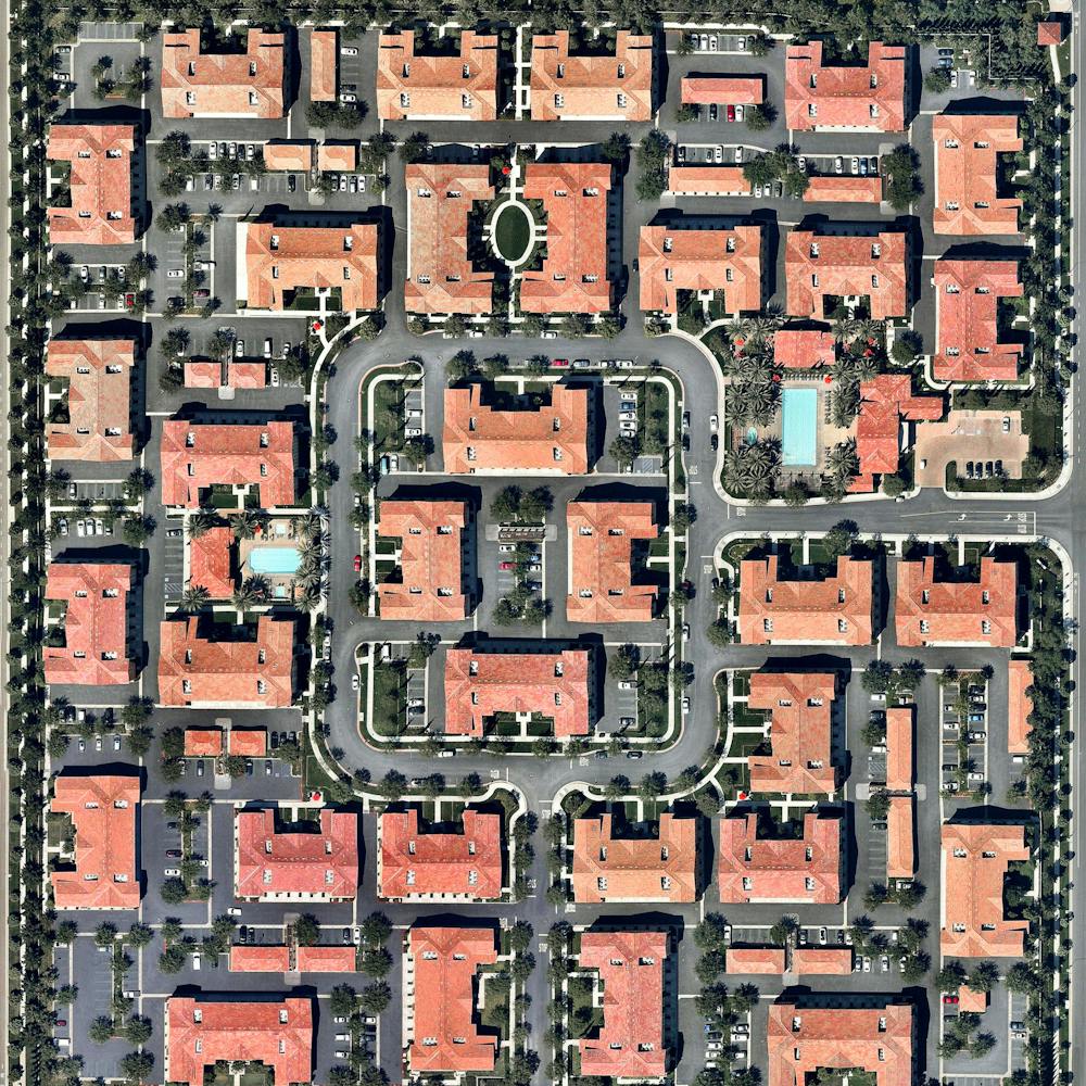
Dallas/Fort Worth International Airport (DFW)
32.896944°, -97.038056° - Dallas, Texas, USADallas/Fort Worth International Airport covers more than 27 square miles (70 sq. km) in Texas — an area larger than the island of Manhattan. It is the fourth busiest airport in the world by aircraft movements and the 14th busiest in the world in terms of passenger traffic, handling 69.1 million travelers in 2018.
Maxar Technologies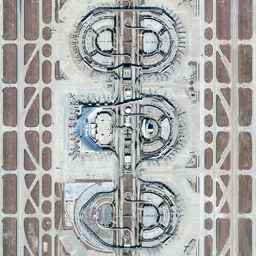
Daly City, California
37.686892°, -122.468020° - 37.686389, -122.468333Skyline Boulevard (officially State Route 35) runs through a residential neighborhood in the Westlake District of Daly City, California. Located just south of San Francisco, Westlake is one of the first post-World War II suburbs in the United States. Its endless rows of uniform homes were the inspiration for Malvina Reynolds' 1962 folk song, "Little Boxes" — which singer Pete Seeger turned into the anti-conformity anthem of its era.
Nearmap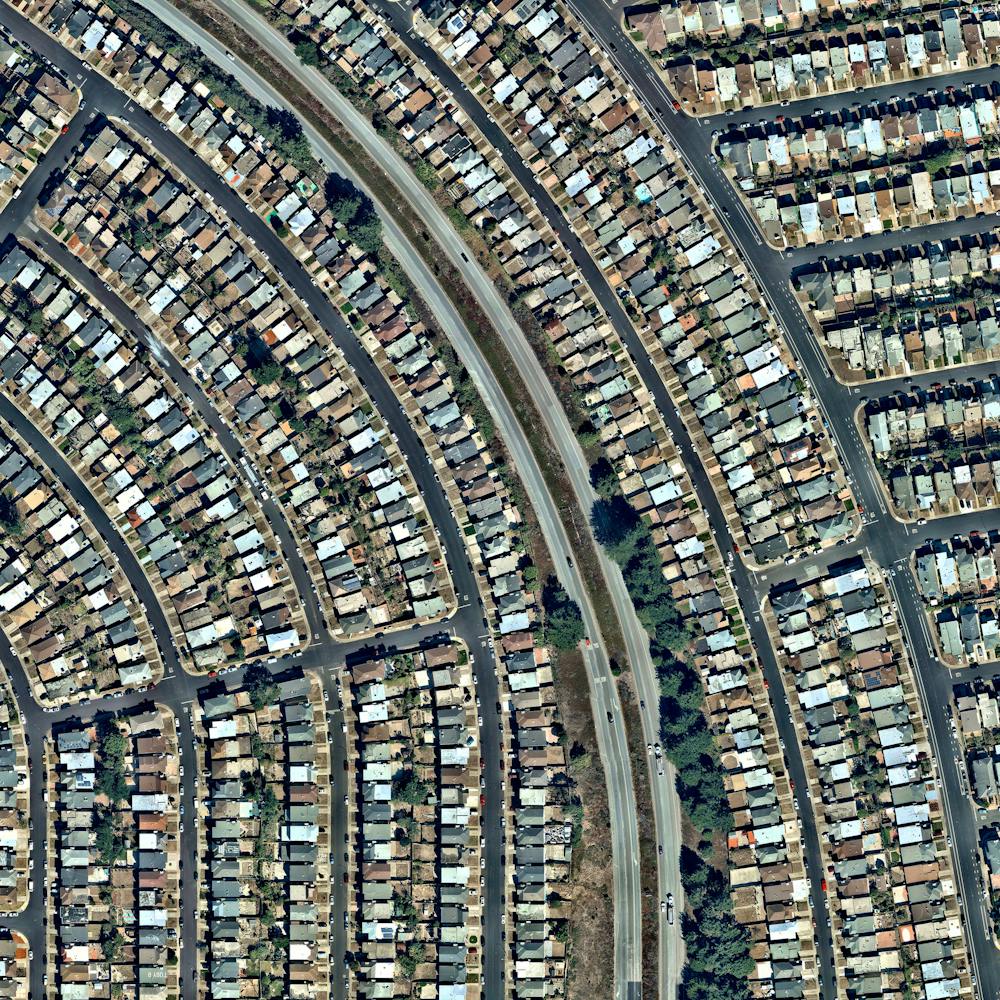
Damascus
33.521239°, 36.286614° - Damascus, SyriaDamascus is the capital and second largest city in Syria. It is one of the world's oldest continuously inhabited cities, with its earliest settlement in approximately 6300 BC. This photograph was captured in March of 2010, one year before the outbreak of the civil war that continues to plague the country.
Maxar Technologies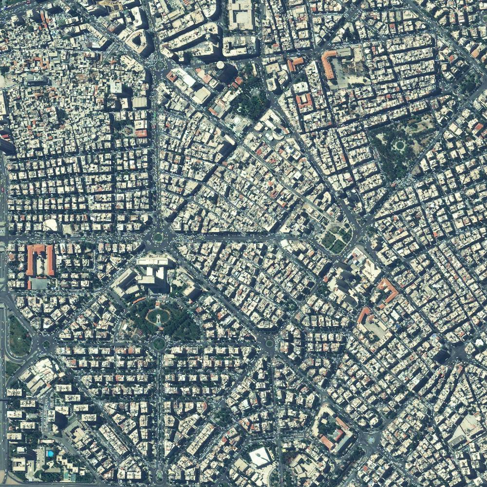
Dampier Creek
-17.959000°, 122.247167° - Broome, Western AustraliaDampier Creek winds its way inland to form the eastern border of Broome, a coastal town in Western Australia. Broome is home to roughly 14,000 people, but its population can grow to upwards of 45,000 per month during peak tourist season from June to August. Its 14-mile (22-km) white-sand Cable Beach, paleontology exhibits, pearl farms, and other attractions make it a popular destination for travelers around the world.
Maxar Technologies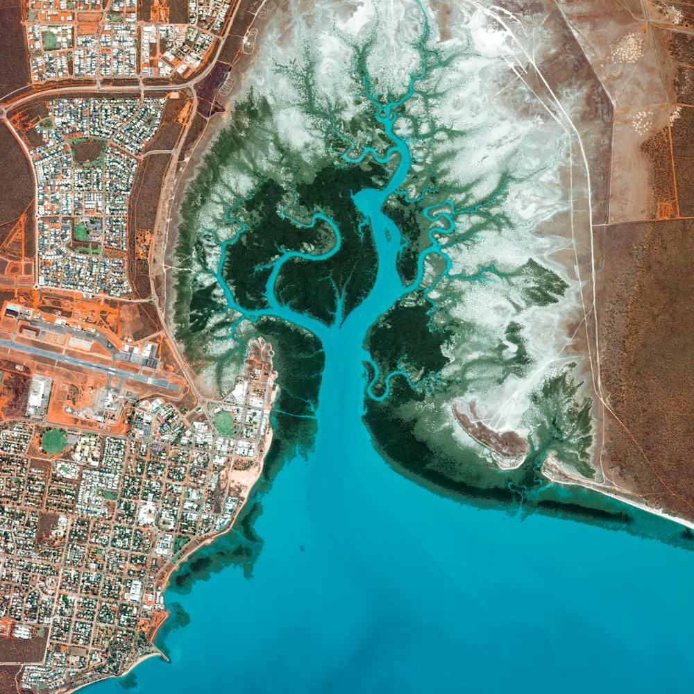
Danakil Depression
14.240259°, 40.298674° - Afar, EthiopiaThe Danakil Depression is located in the Afar Region of Ethiopia. It lies on the junction of three tectonic plates and is the hottest region on Earth in terms of year-round temperatures. The Dallol crater, seen here, was formed by the intrusion of basaltic magma into salt deposits and subsequent hydrothermal activity. Any microorganisms living here would be categorized as 'extremophilic microbes' and are of major interest to the scientists studying the area to better understand how life might occur on other planets.
Maxar Technologies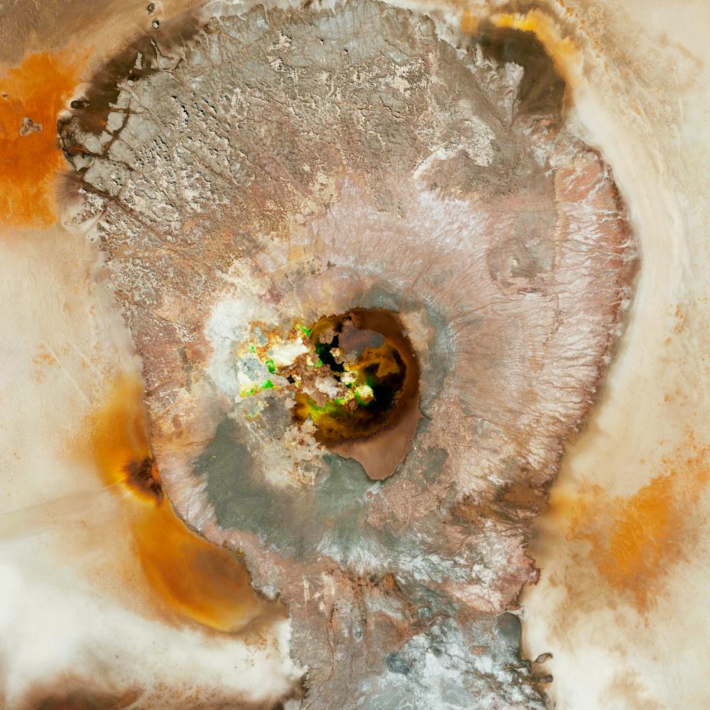
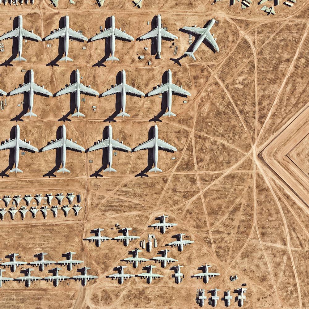
Davis–Monthan AFB
32.150574°, -110.827969° - Tuscon, ArizonaThe largest aircraft storage and preservation facility in the world is located at Davis–Monthan Air Force Base in Tucson, Arizona. The facility - run by the 309th Aerospace Maintenance and Regeneration Group - contains more than 4,400 retired American military and government aircraft.
Nearmap