 Explore
 Shop
Shop About
About Search
Overview Index
Port of Long Beach
33.754185°, -118.216458° - Long Beach, CaliforniaShipping containers are loaded into a massive cargo ship (1200+ feet) at the Port of Long Beach — the second-busiest container port in the United States. The seaport generates approximately $100 billion in trade, employs more than 316,000 people, and along with the Port of Los Angeles to which it is connected, serves as the single largest source of air pollution in the metropolitan LA area.
Nearmap
Port of Los Angeles
33.729167°, -118.261944° - Los Angeles, California, USAThe Port of Los Angeles is the busiest container port in the United States, but only the 16th-busiest in the world. Approximately $1.2 billion worth of cargo comes through the facility each day and more than 165 million metric revenue tons of cargo are moved here each year. The most-imported types of goods are furniture, automobile parts, apparel, electronic products, and footwear.
Maxar Technologies
Port of Los Angeles Trucks
33.728611°, -118.240333° - Los Angeles, California, USALong-haul trucks wait in line to exit the Port of Los Angeles in California. It is estimated that there are approximately 3.5 million truck drivers in the United States and they drive nearly 140 billion miles on American highways every year. In total, 433 billion miles are covered annually by the entire population.
Nearmap
Port of Rotterdam
51.950990°, 4.065449° - Rotterdam, NetherlandsTwo container ships are docked at the Port of Rotterdam in the Netherlands. From 1962 until 2002 it was the world’s busiest port, but was overtaken first by the the port in Singapore and later by the facility in Shanghai, China. Container ships such as these can weigh up to 300,000 tons and extend up to 1,200 feet (366 meters).
Maxar Technologies
Port of Rotterdam
51.952790°, 4.053669° - Rotterdam, NetherlandsShipping containers are seen at the Port of Rotterdam in the Netherlands. From 1962 until 2002, the facility was the world’s busiest port, but was overtaken first Singapore and later Shanghai. In 2015, Rotterdam ranked as the world’s sixth-largest port in terms of annual cargo tonnage.
Maxar Technologies
Port of Rotterdam Dry Terminal
51.938843°, 4.047934° - Rotterdam, NetherlandsThe dry terminal at the Port of Rotterdam in the Netherlands is the busiest transshipment facility of its kind in Europe - moving primarily coal and iron ore. The massive vessels that dock here carry up to 380,000 tonnes of these minerals to power plants and blast-furnaces in Germany, France, Belgium, and other European countries.
Maxar Technologies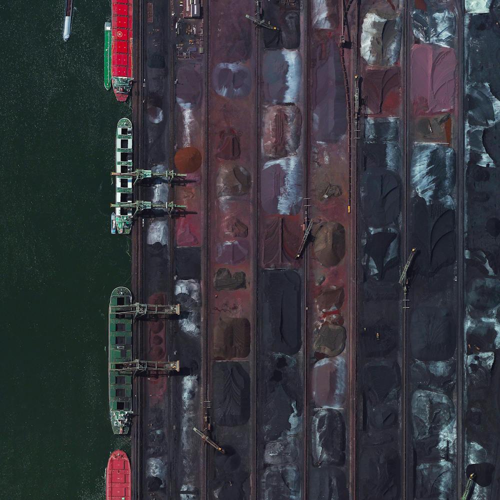
Port of Savannah
32.128705°, -81.151907° - 32.128705°, -81.151907°The Port of Savannah is a major U.S. seaport located in the city of Savannah, Georgia. Its facilities for oceangoing vessels line both sides of the Savannah River, approximately 18 miles (29 km) from the Atlantic Ocean. Between July 2018 and 2019, a record 4.5 million twenty-foot equivalent container units were moved at the Port of Savannah.
Nearmap
Port of Shanghai
30.626393°, 122.062528° - Shanghai, ChinaThe Port of Shanghai is the world’s busiest container port, handling more than 35 million TEUs (approximately 776 million tons) of cargo every year. That weight is roughly equal to 1.7 times the mass of all humans living on the planet.
Maxar Technologies
Port of Tacoma
47.262278°, -122.389556° - Tacoma, Washington, USAA freighter full of shipping containers docks in the Port of Tacoma, located in Washington State. Together, the Ports of Tacoma and Seattle make up the fourth-largest container gateway in North America. In 2016, cargo traffic through the ports totaled 3.6 million twenty-foot equivalent units (TEUs) weighing 28 million metric tons.
Nearmap
Port of Tacoma Roofing Storage
47.259306°, -122.405611° - Tacoma, Washington, USAWooden pallets of roofing material are stacked next to the Port of Tacoma, Washington. In 2015, the Port of Tacoma handled $52.1 billion in international trade, importing and exporting 19 million short tons of cargo.
Nearmap
Port of Tanjung Priok
-6.104000°, 106.886500° - Jakarta, IndonesiaDozens of massive cargo ships and tankers - some weighing up to 300,000 tons - are anchored outside the Port of Tanjung Priok in Jakarta, Indonesia. The facility is the country's busiest and most advanced seaport, handling more than 50% of Indonesia's trans-shipment cargo. The port is also among the least efficient in all of Southeast Asia, due to slow customs handling and limited docking capacity.
Maxar Technologies
Port of Vancouver
49.017889°, -123.159583° - Vancouver, CanadaThe Roberts Bank Superport is a shipping facility in the Port of Vancouver, just offshore the city of Delta in British Columbia, Canada. It is home to the single busiest coal export terminal in North America, which typically ships more than 20 million tons of export coal a year. Currently, there are plans to expand the facility and add a new three-berth container terminal, which would provide an additional 2.4 million twenty-foot equivalent units of container capacity.
Nearmap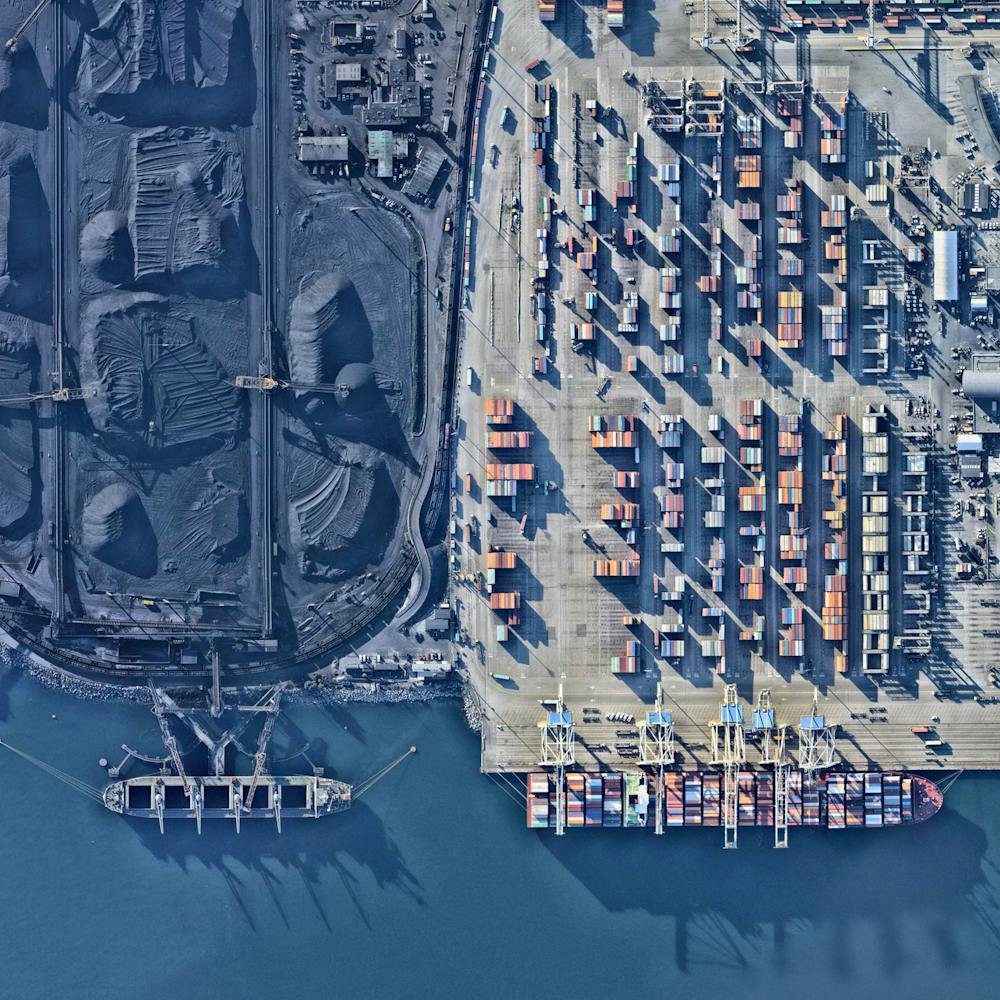
Port Vauban
43.586556°, 7.125861° - Antibes, FranceMassive yachts are docked in the stunning blue water of Port Vauban, a harbor located in Antibes on the French Riviera. The facility is the largest marina on the Mediterranean Sea in terms of total tonnage of the boats that are moored here.
Maxar Technologies
Princess Juliana International Airport
18.040823°, -63.109948° - Saint MartinPrincess Juliana International Airport is the main airport on the Caribbean island of Saint Martin. The airport is well-known for the approach to Runway 10, seen at the bottom of this Overview. Here arriving aircraft must have a 3° glide slope, flying at a shockingly low altitude over people relaxing on Maho Beach, to land safely.
Maxar Technologies
Qantas Jet Over Adelaide
-34.936082°, 138.602692° - Adelaide, AustraliaA Qantas jet flies over Wakefield Street in Adelaide, South Australia, after taking off from Adelaide Airport. Adelaide is the fifth-largest city in Australia, and its airport is the country’s fifth-busiest. Between 2016 and 2017, it served roughly 8 million passengers and saw an 11% increase in international travelers.
Nearmap
Rapid City Salvage Yard
44.109263°, -103.184094° - Rapid City, South Dakota, USAThousands of vehicles are stored at a salvage yard in Rapid City, South Dakota, where they will be scrapped for usable parts and recycled back into raw materials. In the U.S. alone, between 12 and 15 million vehicles reach the end of their lives every year, making them the most-recycled consumer product in the nation. Currently, about 75% of all vehicle materials can be salvaged and recycled.
Nearmap
Roseville Yard
38.728268°, -121.312351° - Roseville, California, USARoseville Yard, located north of Sacramento, California is the largest rail facility on the west coast of the United States. Operated by the Union Pacific Railroad, the yard accommodates approximately 98 percent of all rail traffic in the north of the state.
Maxar Technologies
Rottnest Island Yacht
-31.994995°, 115.560582° - Perth, AustraliaA yacht cruises around Rottnest Island, located off the coast of Perth, Western Australia. The dark blotches seen in the water are parts of the Kingston Reef — one of five Marine Sanctuary Zones surrounding the island. These zones form a habitat for many species of fish and crustaceans, bottlenose dolphins, blue whales, Australian sea lions, New Zealand fur seals, and migrating humpbacks.
Nearmap
San Francisco Bay Container Ship
37.767035°, -122.417378° - San Francisco Bay, California, USAA ship full of containerized cargo navigates San Francisco Bay, located between San Francisco and Oakland, California. Due to San Francisco's limited real estate, Oakland has served as the primary Bay Area port since the 1960s. The Port of San Francisco handled no containerized cargo in 2017, whereas the Port of Oakland had a throughput of nearly 2.5 million twenty-foot equivalent units (TEUs) that year.
Nearmap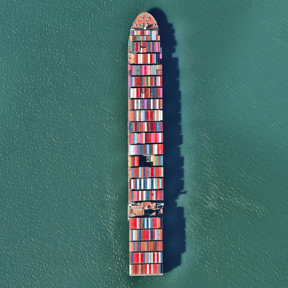
San Francisco International Airport (SFO)
37.618889°, -122.375000° - San Francisco, California, USASan Francisco International Airport is the twenty-first busiest airport in the world by passenger traffic, accommodating more than 50 million passengers every year.
Maxar Technologies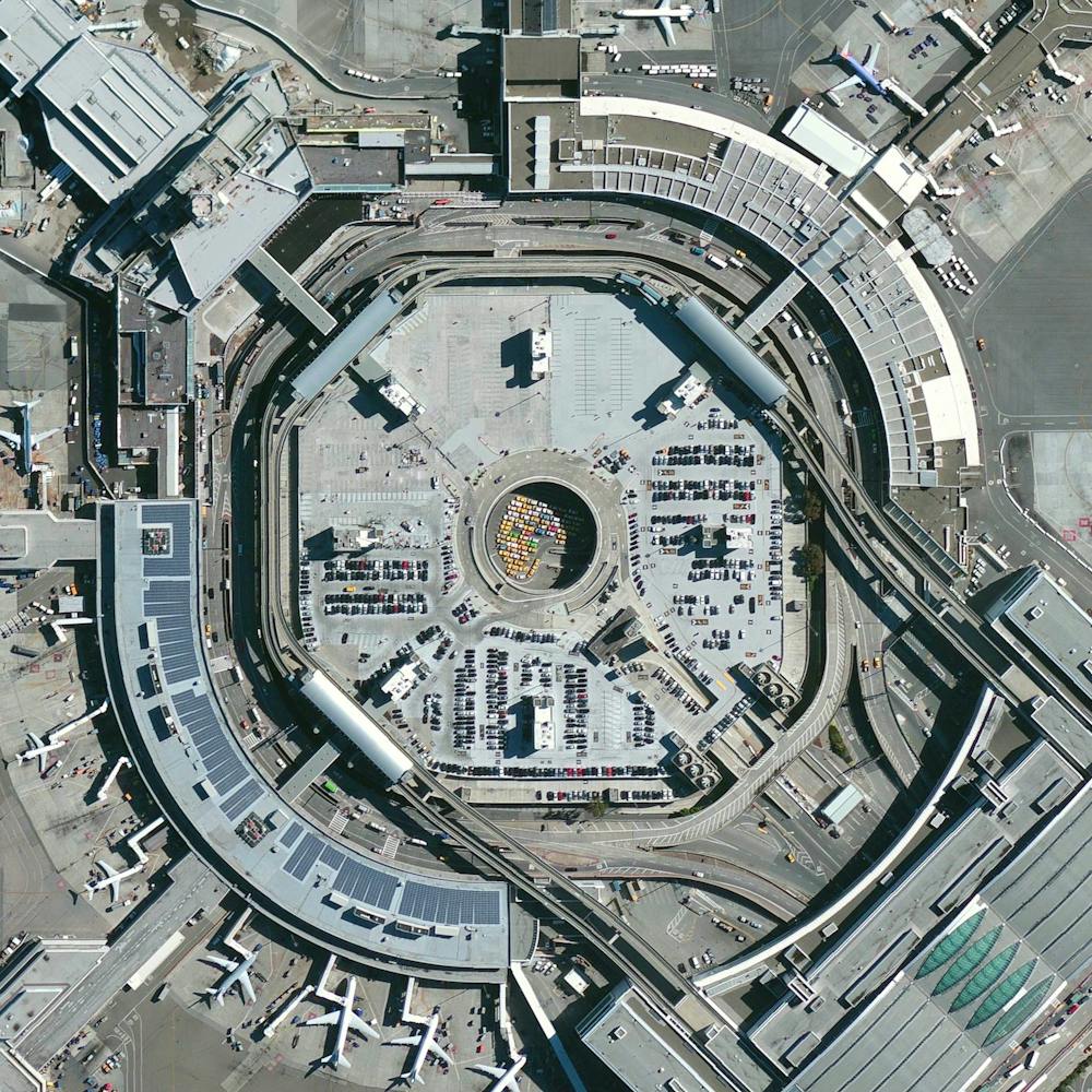
Saskatoon Airplanes
52.169389°, -106.681472° - Saskatoon, Saskatchewan, CanadaSeveral jets are parked outside a hangar at the John G. Diefenbaker International Airport in Saskatoon, Saskatchewan, Canada. With two runways, nine passenger bridges and three ground-loading positions, the airport handles just under 1.5 million passengers per year. By contrast, the busiest airport in Canada (Toronto Pearson International) handles nearly 50 million passengers annually.
Nearmap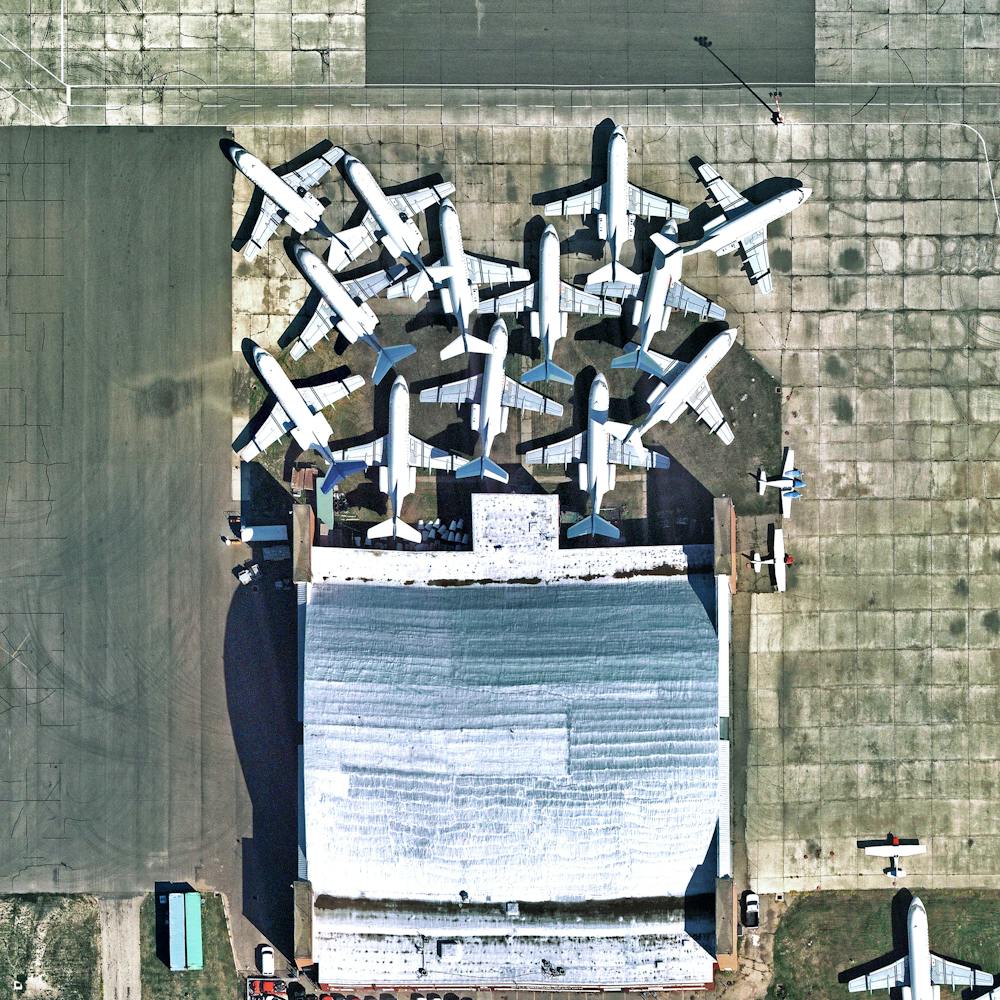
School Bus Assembly Plant
36.189292°, -95.875041° - Tulsa, Oklahoma, USAHundreds of school buses are seen at an assembly plant in Tulsa, Oklahoma, USA. The standard American school bus is 45 feet (13.7 meters) long and has a seating capacity of up to 90 passengers. This particular facility manufactures 50 to 75 buses a day on average.
Nearmap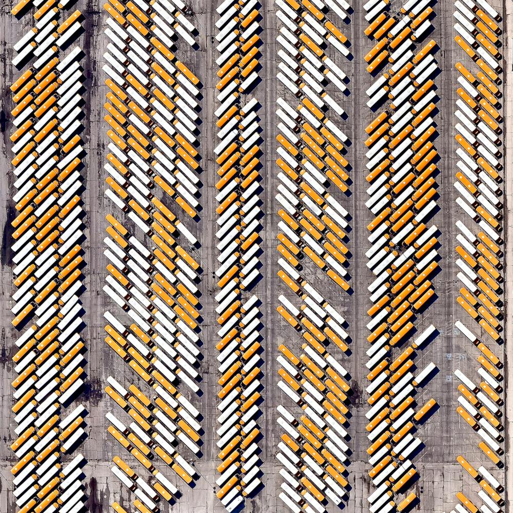
Seattle-Tacoma International Airport
47.448889°, -122.309444° - Seattle, Washington, USAI’ll be heading to Seattle, Washington, this morning for the State of the Map Conference! My flight to Seattle-Tacoma International Airport will be one of the roughly 380,000 aircraft movements that take place at the facility each year and I will be one of roughly 42 millions passengers that travel through the airport annually. The facility also contains a 13,000-car parking garage, the largest structure of its kind in North America, which is visible at the top of this Overview.
Maxar Technologies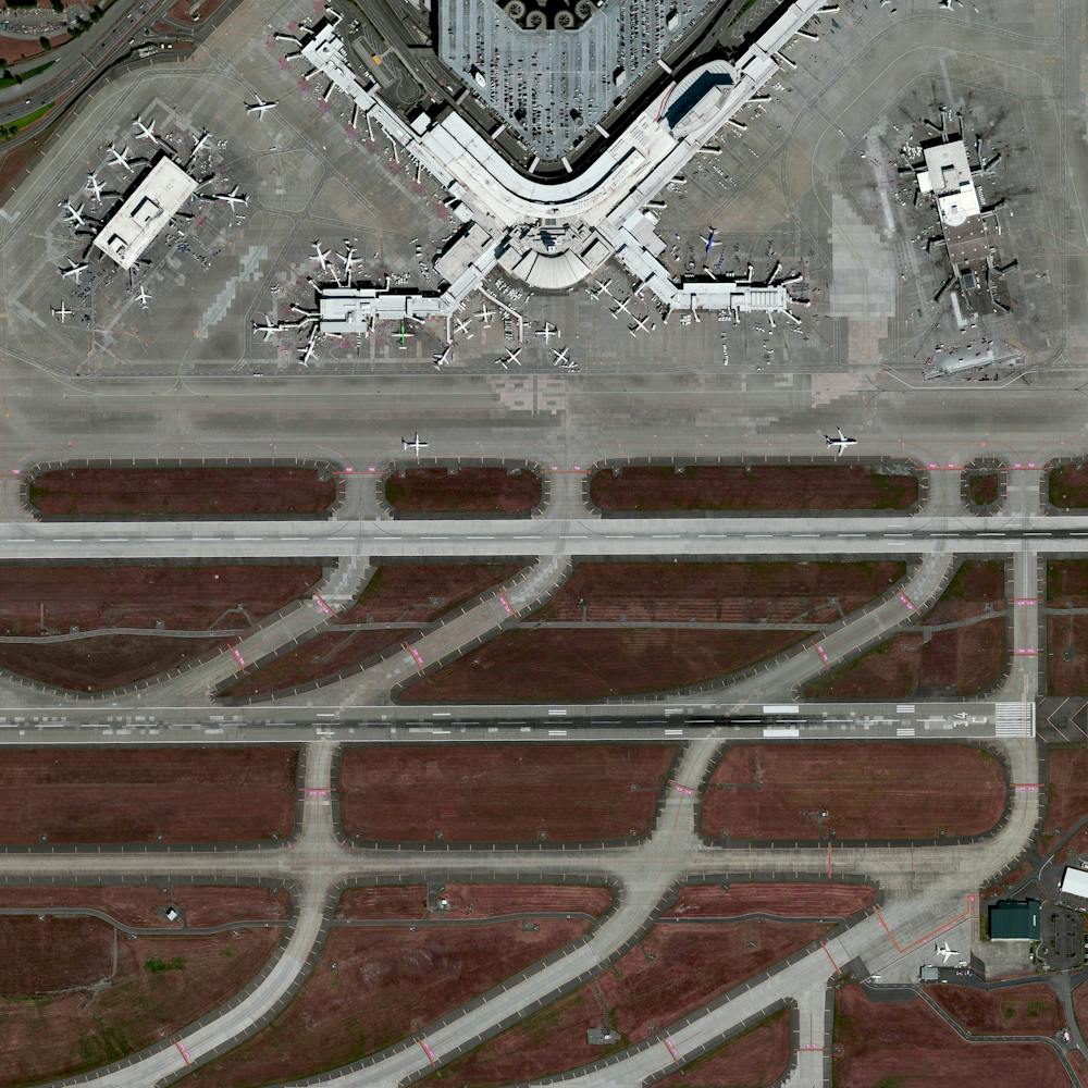
Selkirk Yard
42.554722°, -73.837222° - Selkirk, New York, USASelkirk Yard is a freight railroad yard located eight miles south of Albany, New York that serves as a gateway to points east of the Hudson River, including New York City. Using computerized controls, the yard can process more than 3,200 cars per day.
Maxar Technologies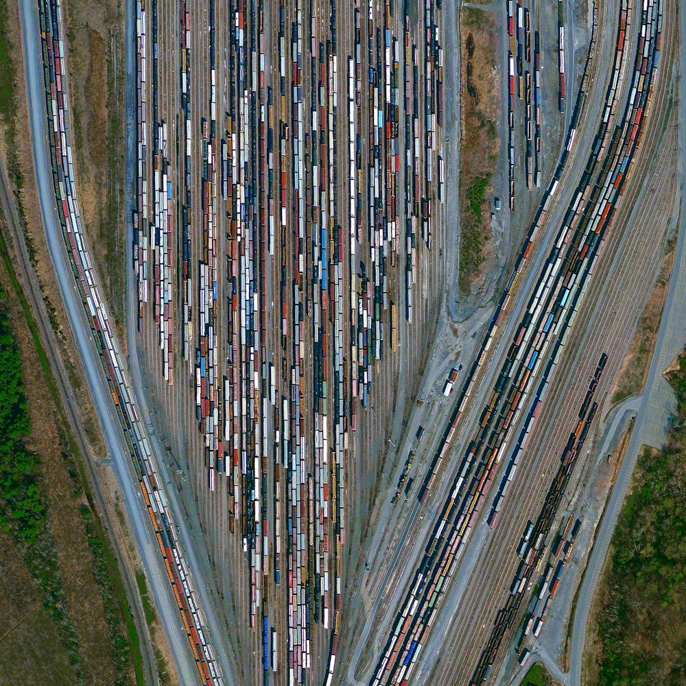
Seymour Johnson Air Force Base
35.351000°, -77.963000° - Goldsboro, North CarolinaPlanes sit under coverings on the tarmac of Seymour Johnson Air Force Base in Goldsboro, North Carolina. The base was established in June 1942 and served as a training facility throughout World War II before it was deactivated in May 1946. Since reopening as a Tactical Air Command Base in 1956, it has been home to B-52 bombers, KC-10 and KC-135 tankers, and F-4 and F-16 fighters.
Nearmap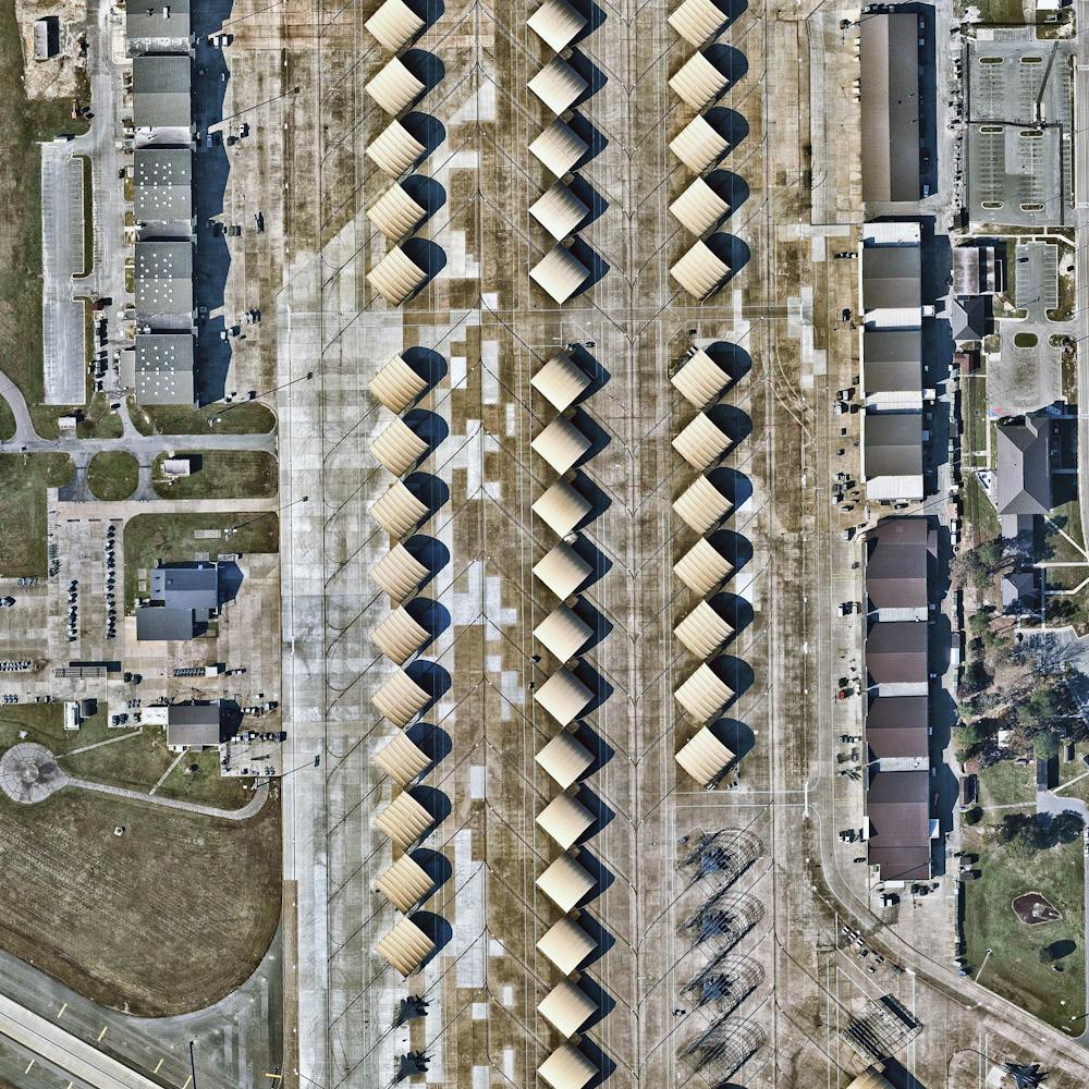
Shanghai Interchange
31.118920°, 121.388230° - Shanghai, ChinaA highway interchange connects three major roads - the S20, G60, and S4 - in Shanghai, China. The city is home to roughly 2.5 million cars and 24 million people.
Maxar Technologies
Singapore Tankers
1.255944°, 103.781000° - SingaporeCheck out this Overview, which captures cargo ships and tankers — some weighing up to 300,000 tons — outside of the entry to the Port of Singapore. The facility is the world's second-busiest port in terms of total tonnage, shipping a fifth of the world's cargo containers and half of the world's annual supply of crude oil.
Maxar Technologies
Soekarno-Hatta International Airport (CGK)
-6.127523°, 106.651512° - Jakarta, Java, IndonesiaSoekarno-Hatta International Airport in Jakarta, Indonesia is the 9th busiest airport in the world, serving approximately 57.8 million passengers each year.
Maxar Technologies
Sound of Speed Airshow
39.771944°, -94.909694° - St. Joseph, Missouri, USAIn this Overview, spectators explore a variety of aircraft during the Sound of Speed Airshow, which took place last weekend at Rosecrans Memorial Airport in St. Joseph, Missouri. The event included aerial performances and ground displays of dozens of aircraft, including U.S. Navy Blue Angels, C-130 Hercules transporters, P-51 Mustangs, an F-16 Viper, and more.
Nearmap
Southern California Airplane Boneyard
34.597500°, -117.383056° - Victorville, California, USAIn this Overview, 25 airplanes are parked in a cluster at the Southern California Logistics Airport in Victorville, California. Also known as Victorville Airport, it is home to Southern California Aviation, a large transitional facility for commercial aircraft. No commercial passenger services are offered at the airport except for fixed-based operator and charter flights.
Nearmap