 Explore
 Shop
Shop About
About Search
Overview Index
Friedenau
52.471692°, 13.328281° - Berlin, GermanyFriedenau is a neighborhood in the southwestern suburbs of Berlin, Germany. The streets and squares of Friedenau are laid out in a geometric urban design known as a Carstenn Figure. This type of plan is characterized by a circular road that is divided by central avenue.
Maxar Technologies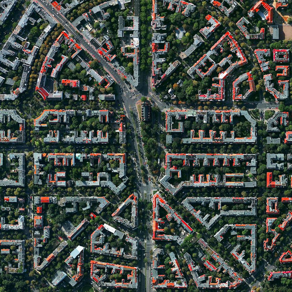
Guadalajara
20.676667°, -103.347500° - Guadalajara, MexicoGuadalajara is the capital of and largest city in the Mexican state of Jalisco, with upwards of 5 million people living in its metropolitan area. It is also the second most densely populated municipality in Mexico, behind Ciudad Nezahualcóyotl. Guadalajara is a Mexican cultural hub, considered by many to be the home of mariachi music.
Maxar Technologies
Guadalajara
20.689540°, -103.312179° - Guadalajara, MexicoGuadalajara is the second most populous city in Mexico with a population of nearly 1.5 million. It is also one of the country’s cultural centers, considered by many to be the home of mariachi music.
Maxar Technologies
Guadalajara
20.687580°, -103.307078° - Guadalajara, MexicoGuadalajara is the fourth most populous city in Mexico with a population of nearly 1.5 million. It is also one of the country’s cultural centers, considered by many to be the home of mariachi music.
Maxar Technologies
Hamburg
53.550530°, 9.969369° - Hamburg, GermanySituated on the River Elbe, Hamburg is the second largest city in Germany and eighth largest in the European Union. The city center, seen here, is situated around the Binnenalster, one of two artificial lakes built within its limits. Hamburg also contains the second largest port in Europe, which ships roughly 134 million tons of goods every year.
Maxar Technologies
Heerhugowaard
52.666667°, 4.833333° - Heerhugowaard, NetherlandsHeerhugowaard, Netherlands is home to roughly 55,000 people. Because of extensive peat extraction and storm floods, many lakes developed in the region, including the one on which the town located. The reclaimed land of Heerhugowaard is situated three meters below sea level.
Maxar Technologies
Ho Chi Minh City
10.776889°, 106.700806° - Ho Chi Minh City, VietnamHo Chi Minh City is the largest city in Vietnam with more than 10 million residents in its metropolitan area. Formerly known as Saigon, the city is expected to grow to 13.9 million by 2025. This stunning photo was sent to us by
Maxar Technologies
Hong Kong
22.118306°, 113.999195° - Hong KongHong Kong is an autonomous territory — and former British colony — in southeastern China. Originally a sparsely populated area of farming and fishing villages, it has become one of the world’s most significant financial centers and commercial ports. Hong Kong has the largest number of skyscrapers in the world, most of which surround Victoria Harbor and are captured in this Overview.
Maxar Technologies
Honolulu
21.327976°, -157.939159° - Honolulu, Hawaii, USAHonolulu is the capital and largest city in the U.S. state of Hawaii. Located along the southeastern coast of Oahu Island, it is the most remote city of its size in the world. The Honolulu Volcanic Series is partially located inside the city, and Diamond Head — a prominent volcanic cone — is visible in this Overview along the southern coast.
Maxar Technologies
Industrial buildings
33.740293°, -118.031207° - Westminster, California, USAIndustrial buildings cover approximately one square mile in Westminster, a city in the Los Angeles metropolitan area of California, USA. The complex includes numerous warehouses, a roller skating rink, and multiple engineering facilities.
Maxar Technologies
Island Walk
26.251389°, -81.710250° - Naples, Florida, USAThe Island Walk neighborhood in Naples, Florida, is home to slightly more than 3,000 people. Since many cities in the state of Florida contain master-planned communities — often built on top of waterways in the latter half of the twentieth century — a number of intricate designs like this one are visible from the Overview perspective.
Nearmap
Istanbul at night
41.007964°, 28.969139° - Istanbul, TurkeyIstanbul is the largest metropolitan area in Turkey, with a population of more than 14 million people. This Overview was captured at night from the International Space Station.
NASA
Jeongwang-dong
37.336147°, 126.718587° - Ansan, South KoreaJeongwang-dong is an industrial sector in the city of Ansan, South Korea. The Korean government intensively drove a plan to develop the modern city, particularly in this area, with an emphasis on manufacturing. The striking blue color that you see here results from the use of aluminum roofing, which is used for its low cost and longevity.
Maxar Technologies
Jodhpur
26.297840°, 73.018420° - Jodhpur, IndiaJodhpur, India, is home to more than one million residents, making it the second largest city in the state of Rajasthan. Jodhpur is often referred to as the “Blue City” due to the vivid, painted houses that can be seen throughout its urban area.
Maxar Technologies
Jönköping
57.782778°, 14.160556° - Jönköping, SwedenJönköping is a city in southern Sweden with roughly 94,000 inhabitants. It is situated at the southern end of Vättern, Sweden's second largest lake. Our founder Benjamin Grant is currently traveling there and two other towns at the southern end of Vättern to speak and meet with students. He will visit Jönköping University, the town of Hjo, and will do an exhibition of prints in collaboration with Uponwalls in the harbor in Granvik.
Maxar Technologies
Karlsruhe, Germany
49.009167°, 8.403889° - Karlsruhe, GermanyThe city of Karlsruhe, Germany was planned with a palace tower at its center, surrounded by 32 radiating streets. Because the design resembled the ribs of a folding fan, the city is sometimes called the “fan city” or “Fächerstadt." Additionally, this city's urban plan gave rise to the geometry concept of “Karlsruhe Metric” which refers to a measure of distance that assumes travel is only possible along radial streets and along circular avenues around the center.
Maxar Technologies
Key West
24.564635°, -81.815648° - Key West, Florida, USAKey West is an island and city in the Straits of Florida, USA. It is the southernmost city in the contiguous United States and the westernmost island connected by highway in the Florida Keys. The island, which is about 4 miles (6.4 km) long and 1 mile (1.6 km) wide, has a population of approximately 25,000 and was visited by 2.25 million tourists in 2016.
Nearmap
Kingston, Jamaica
18.017924°, -76.870697° - Kingston, JamaicaKingston is the capital and largest city of Jamaica, located on the southeastern coast of the island. More than 660,000 people live in Kingston's metropolitan area, accounting for nearly one-quarter of Jamaica's total population. The city is surrounded by the Blue Mountains, Red Hills, Long Mountain and Kingston Harbour, which is the seventh-largest natural harbor in the world.
Maxar Technologies
Kuşadası
37.859722°, 27.259722° - Kuşadası, TurkeyKuşadası is a resort town located on the Aegean Sea in Turkey. While the town has roughly 64,00 residents for most of year, in the summer months its population can rise to nearly half a million people with the influx of tourists.
Maxar Technologies
Kuta
-8.733333°, 115.166667° - Kuta, Bali, IndonesiaKuta (also known as Kuta Village or Kuta Town) is a village in southern Bali, Indonesia. Originally a small fishing community, it was one of the first places in Bali to see substantial tourism and has become internationally known as a beach resort town. Kuta sits just north of Ngurah Rai International Airport, which is shown at the center of this Overview jutting out into the Indian Ocean.
Maxar Technologies
L'Eixample - Valenica
39.464722°, -0.370000° - Valencia, SpainThe urban plan of the L’Eixample district in Valencia, Spain is characterized by long straight streets, a strict grid pattern crossed by wide avenues, and apartments with communal courtyards. A similar layout was used for the district of the same name in Barcelona. The circular structure in the upper right is the Plaza de Toros de Valencia - the city’s largest bullfighting arena.
Maxar Technologies
La Latina - Madrid
40.411500°, -3.710972° - Madrid, SpainLa Latina is a neighborhood located in the center of Madrid, Spain. The area was named after an old hospital of the same name that was founded in 1499. In the lower left of this Overview, you can also see the popular Mercado de la Cebada market, with its six-panel, multi-colored rooftop.
Maxar Technologies
La Plata
-34.921111°, -57.954444° - -34.921111°, -57.954444°The planned city of La Plata — the capital city of the Province of Buenos Aires, Argentina — is characterized by its strict, square grid pattern. At the 1889 World’s Fair in Paris, the new city was awarded two gold medals in the categories “City of the Future” and “Better Performance Built.” La Plata has a population of around 765,000 people.
Maxar Technologies
Larung Gar
32.152575°, 100.467637° - TibetHundreds of dwellings - all painted in a vibrant red color - make up Larung Gar, the world’s largest Buddhist institute. The settlement is located in a remote valley in Tibet and contains a population that has grown to approximately 20,000 people since its founding in 1980. In recent years, the Chinese government has started to systemically demolish homes and force thousands of occupants out of Larung Gar, claiming the settlement is too crowded and unsafe. They have also closed off the area to all foreigners. Many Tibetans fear the erosion of their language, traditions, and ways of worship in the midst of these incursions by the Chinese government.
Maxar Technologies
Las Vegas at night
36.175000°, -115.136389° - Las Vegas, Nevada, USAThe glowing lights of Las Vegas, Nevada are captured here from the International Space Station. Since the city is entirely surrounded by desert, its brightly lit grid of streets starkly contrasts the dark, undeveloped area on its outskirts. You’ll also notice the Las Vegas Strip - the city’s central avenue that is seen at the middle of this Overview. This particular area is one of the brightest spots on Earth due to the concentration of lights emanating from the hotels and casinos along the road.
NASA
Leimert Park
34.014806°, -118.331361° - Los Angeles, California, USALeimert Park is a residential neighborhood in southern Los Angeles, California. With many blues and jazz night clubs, hip hop venues, and theaters for musicals, comedy performances, poetry readings and award ceremonies, it is often considered the center of Los Angeles’ contemporary African-American arts scene.
Nearmap
Lido Isle
33.612222°, -117.917694° - Newport Beach, California, USALido Isle is a man-made island located in the harbor of Newport Beach, California. There are no commercial facilities on the island other than a small seasonal snack bar, and its only link to the surrounding city is a small bridge. It is solely residential, with approximately 1,800 inhabitants.
Nearmap
Lisbon
38.716287°, -9.139480° - Lisbon, PortugalLisbon is the capital and the largest city in Portugal with an estimated population of 552,700. This Overview captures a sizable portion of the downtown area, including the green space at right called Parque Eduardo VII — a massive city park known for its exotic plants, monuments, and panoramic views of the city. Lisbon is the only capital in Europe located on the Atlantic Ocean.
Maxar Technologies
Lombard Street, San Francisco
37.802306°, -122.419750° - San Francisco, California, USACars wind down the hill of Lombard Street, which runs from east to west in San Francisco, California. With eight hairpin turns dispersed over a one-block section in the Russian Hill neighborhood, Lombard is often referred to as “the most crooked street in the world.”
Nearmap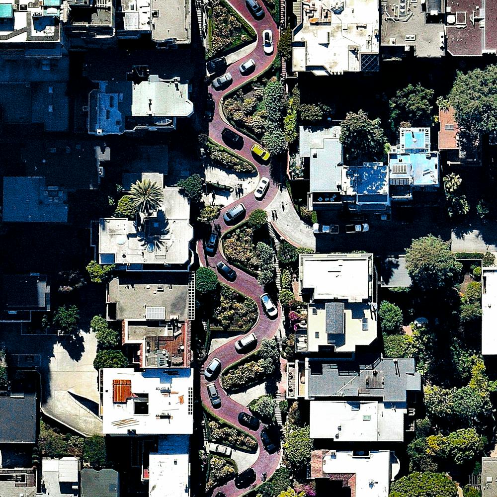
London
51.507222°, -0.127500° - London, England, UKLondon is the capital and most populous city of Great Britain. Situated on the River Thames, London is the world’s most-visited city as measured by international arrivals. We’re excited to announce that one month from today we’ll be hosting the opening for our first ever exhibition in London at theprintspace in Shoreditch. The event is open to the public, and more info can be found in our Facebook event here: . Hope to see some of you there!
Maxar Technologies