Explore
 Shop
Shop About
About Search
Overview Index
Boca Raton
26.386332°, -80.179917° - Boca Raton, FloridaResidential development is seen in Boca Raton, Florida, USA. Because many cities in the state contain master-planned communities, often built on top of waterways in the latter half of the twentieth century, there are a number of intricate designs that are visible from the Overview perspective. Boca Raton is home to roughly 91,000 residents.
Maxar Technologies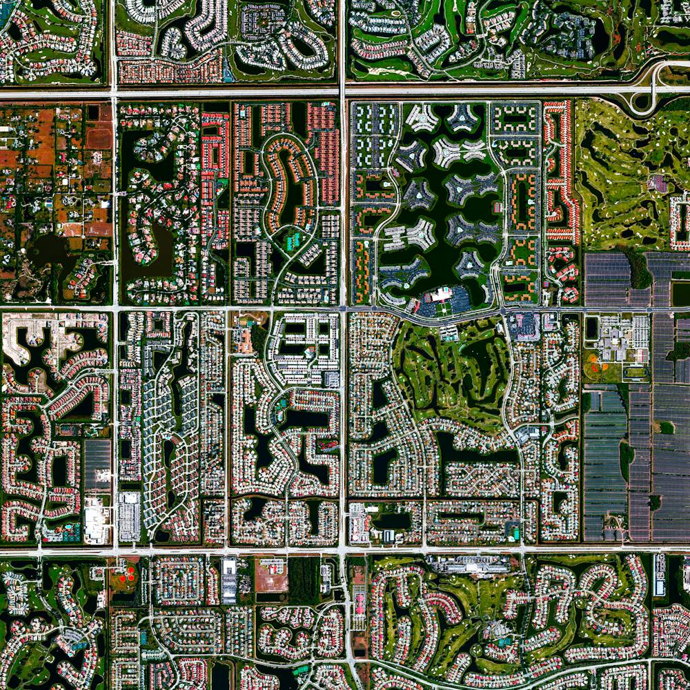
Boca Raton, Florida
26.386333°, -80.179917° - Boca Raton, Florida, USAResidential development is seen in Boca Raton, Florida, USA. Because many cities in the state contain master-planned communities, often built on top of waterways in the latter half of the twentieth century, there are a number of intricate designs that are visible from the Overview perspective. Boca Raton is home to roughly 91,000 residents.
Maxar Technologies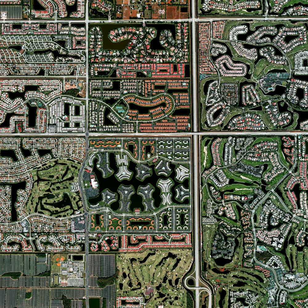
Boeing 737 Max Parking Lot
47.529245°, -122.309162° - Seattle, Washington, USADozens of 737 MAX jetliners cover a parking lot at Boeing's factory in Seattle, Washington. This model has been grounded since March following two fatal crashes in less than six months. July was Boeing's fifth consecutive month without a new order for the 737 MAX and its least productive month for plane deliveries since November 2008.
Nearmap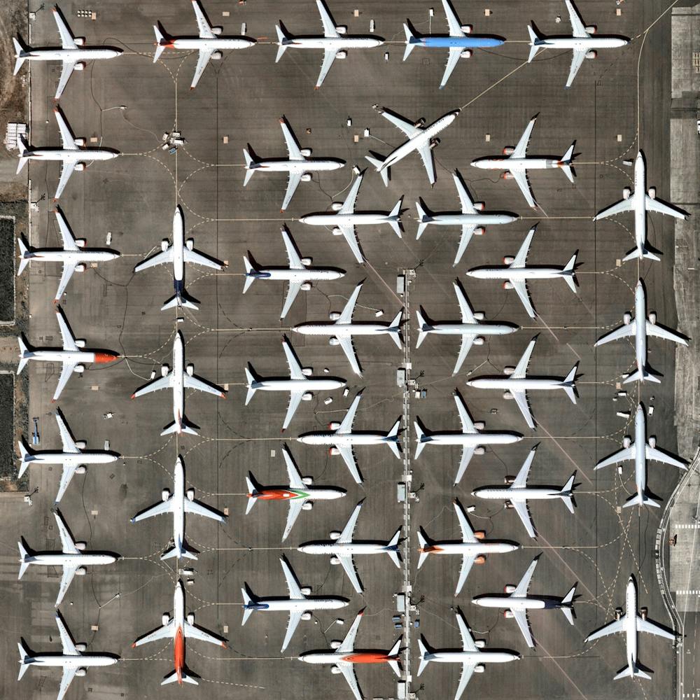
Bolivian Deforestation
-17.387750°, -60.562130° - Santa Cruz, BoliviaDeforestation of the rainforest is visible in Santa Cruz, Bolivia, immediately adjacent to untouched tracts of forest. Deforestation in the country has primarily been driven by the expansion of mechanized agriculture and cattle ranching. According to , initial data for the first half of May showed 17,000 acres (6,880 hectares) of forest had been chopped down in the Amazon, nearly as much as the total for the previous nine months.
Maxar Technologies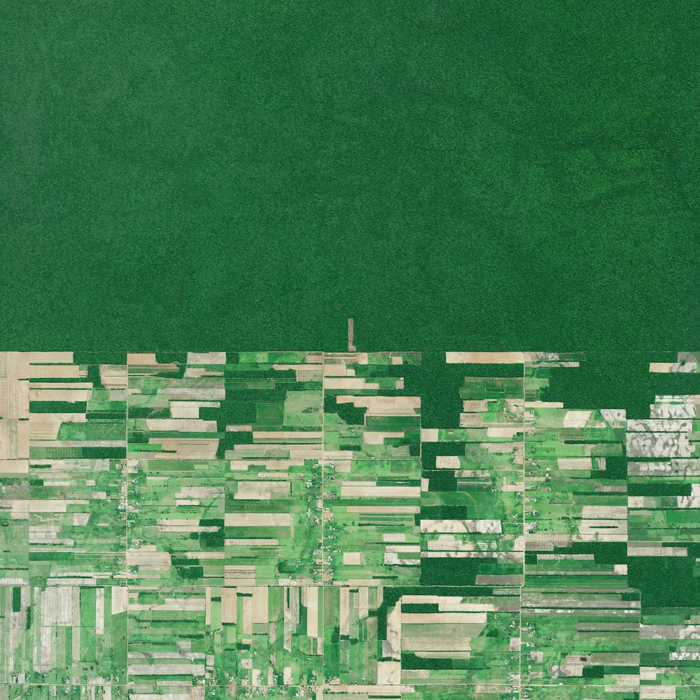
Bondi Beach
-33.891111°, 151.277778° - Sydney, AustraliaBondi Beach and its surrounding suburb are located in Sydney, Australia. One of the city’s most stunning and popular destinations, the beach gets its name from the Aboriginal word “Bondi” that means waves breaking over rocks.
Nearmap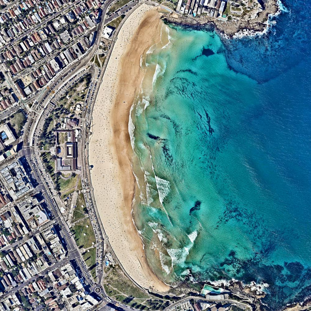
Bondi Beach
-33.891111°, 151.277778° - Sydney, New South WalesIt’s a chilly afternoon up here in New York but it’s already the weekend down at Bondi Beach in Sydney, Australia! One of the city’s most popular destinations, the beach gets its name from the Aboriginal word “Bondi” that means waves breaking over rocks. Tag someone you’ll be seeing this weekend and have a great one, no matter where you are!
Maxar Technologies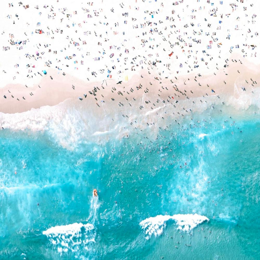
Bosphorus Bridge
41.045278°, 29.034444° - Istanbul, TurkeyThe Bosphorus Bridge is one of two suspension bridges that connects Europe and Asia across the Bosphorus Strait in Istanbul, Turkey. Last night, members of the Turkish military closed down the bridges during an attempt to seize control from the ruling government. News media are now reporting that government forces have reasserted their control over the country.
Maxar Technologies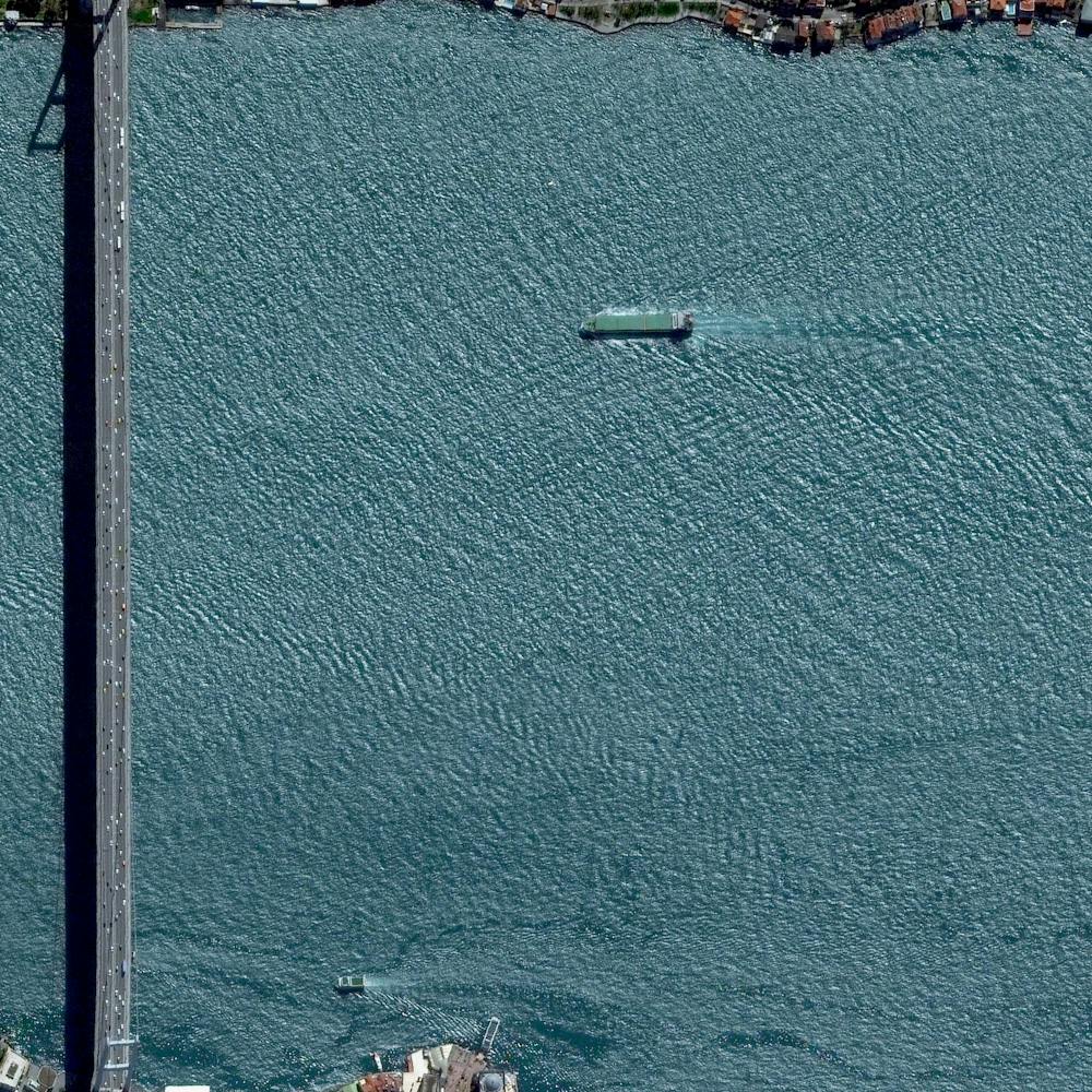
Boston
42.352238°, -71.159486° - Boston, Massachusetts, USABoston is the capital and most populous city in the Commonwealth of Massachusetts, with more than 4.6 million people in its metro area. In this Overview, three waterways can be seen flowing through the city and emptying into Boston Harbor — Chelsea Creek at left; the Mystic River in the center; and the Charles River at right.
Nearmap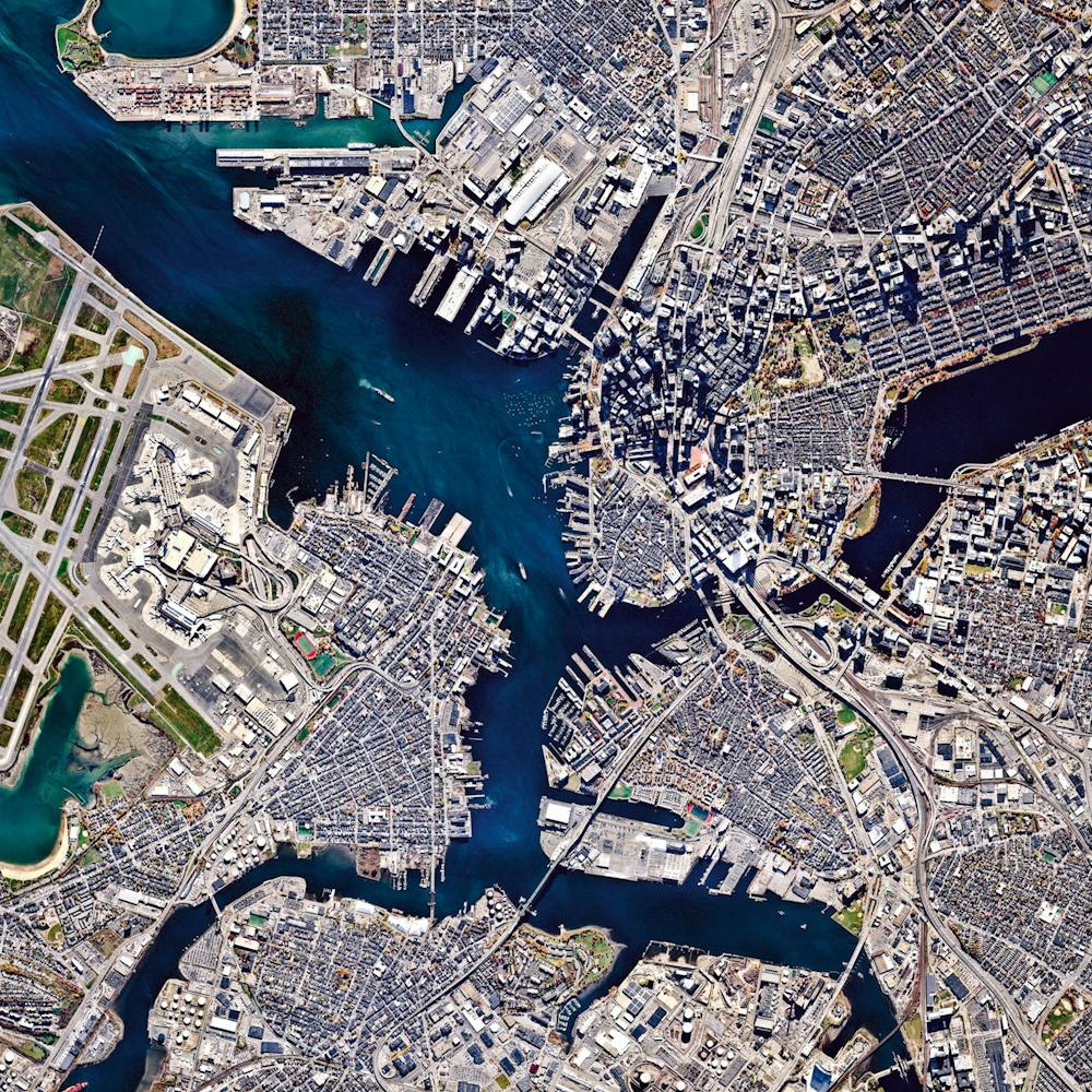
Bourg-Royal
46.882624°, -71.257800° - 46.882624°, -71.257800°Bourg-Royal is one of 35 neighborhoods in Quebec City, Quebec, Canada. The suburb’s streets are arranged in a semi-circular pattern around a square center, leaving room for lawn space and — as is evident in this Overview — nearly every home to have a pool. Bourg-Royal is home to approximately 14,000 people.
Nearmap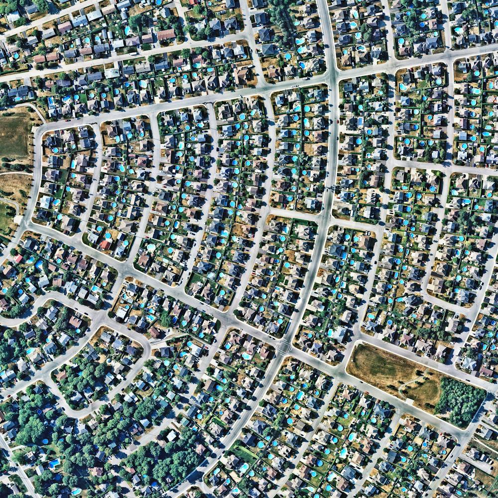
Bourtange
53.006600°, 7.192000° - Bourtange, NetherlandsBourtange is a star fort located in the Groningen Province of the Netherlands. It was constructed in 1593, during the Eighty Years’ War, to control the only road between Germany and the city of Groningen. Today, the fort serves as a historical museum and the surrounding village of Bourtange has an population of 430.
Maxar Technologies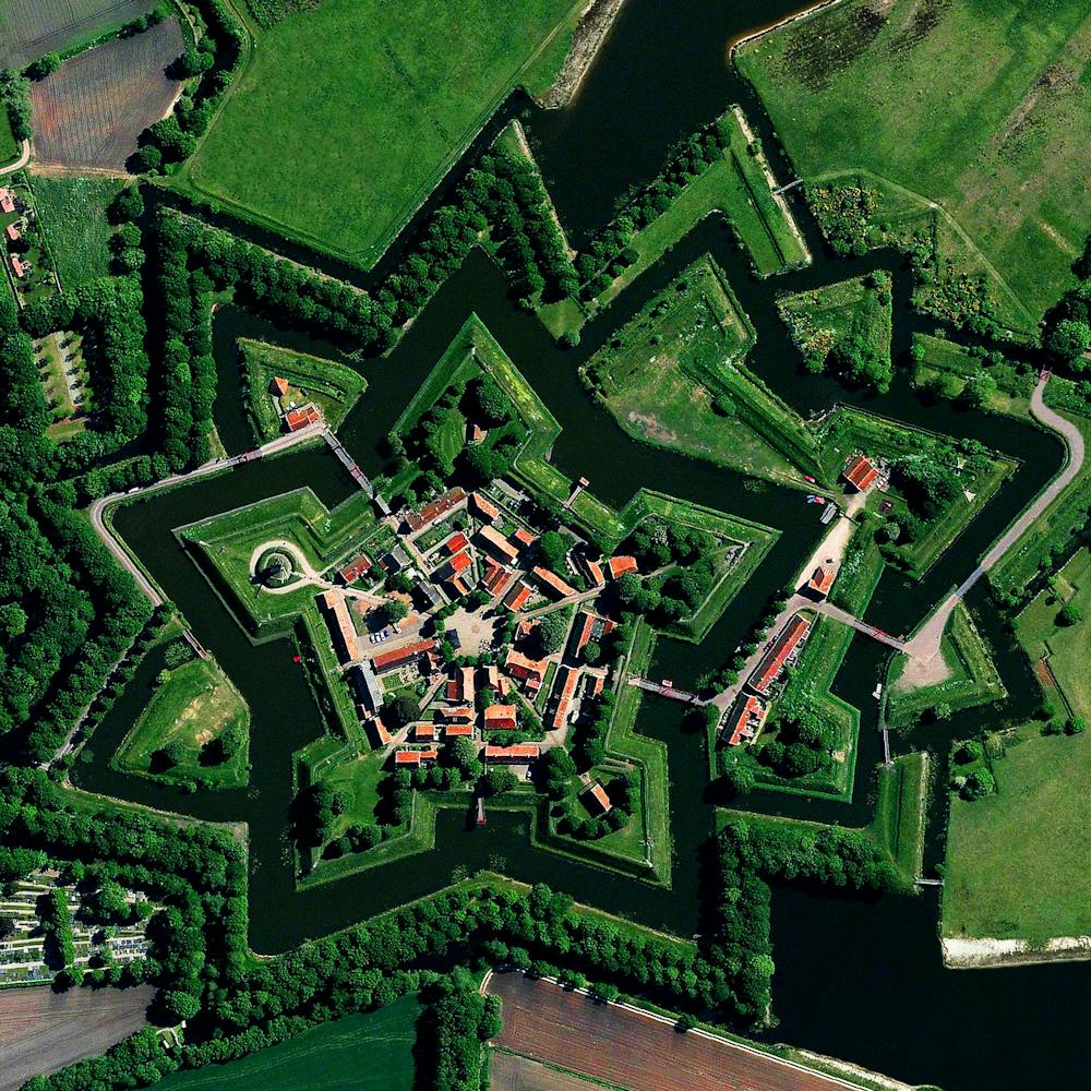
Brasilia
-15.793888°, -47.882777° - Brasilia, BrazilThis Overview captures the urban plan of Brasilia. The city was founded on April 21, 1960, in order to move the capital from Rio de Janeiro to a more central location within Brazil. The design — resembling an airplane from above — was developed by Lúcio Costa and prominently features the modernist buildings of the celebrated architect Oscar Niemeyer at its center.
Maxar Technologies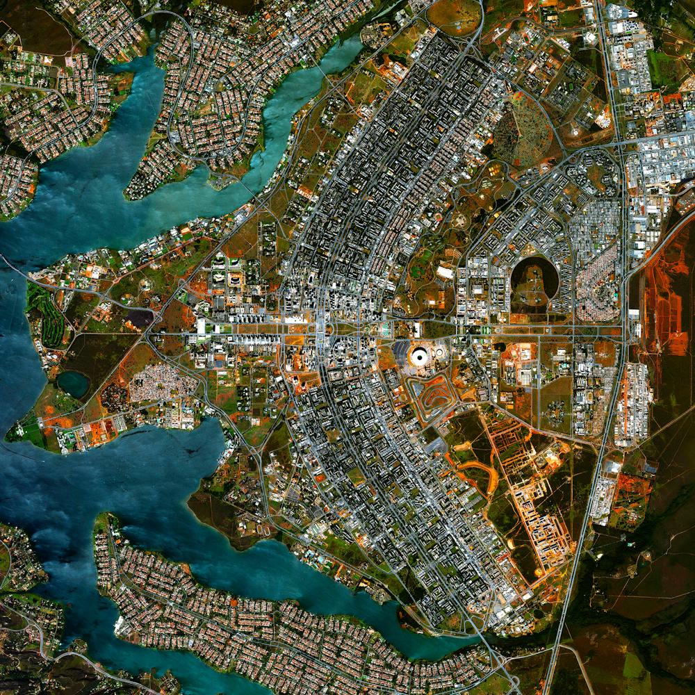
Brazilian Mine Disaster Juxtapose
-20.237096°, -43.421697° - Bento Rodriguez, BrazilOn 5 November 2015, two dams collapsed at an iron ore mine in southeastern Brazil. News outlets estimated that approximately 62 million cubic metres (81 million cubic yards) of toxic waste water (similar to the red mud on previous page) was unleashed. As seen in this Juxtapose, the immediate release of sludge wiped out the village of Bento Rodrigues, resulting in the death of 17 people. Because of this pollution, more than half a million people did not have access to clean drinking water or water to irrigate crops for an extended period of time. Furthermore, within two weeks of the dam rupture, the contaminated waters had spread across a 644-kilometre (400-mile) stretch of the Doce River and entered into the Atlantic Ocean, killing significant amounts of plant and animal life along the way. Officials are concerned that the toxins will continue to threaten the Comboios Nature Reserve, a protected area for the endangered leatherback turtle.
Maxar Technologies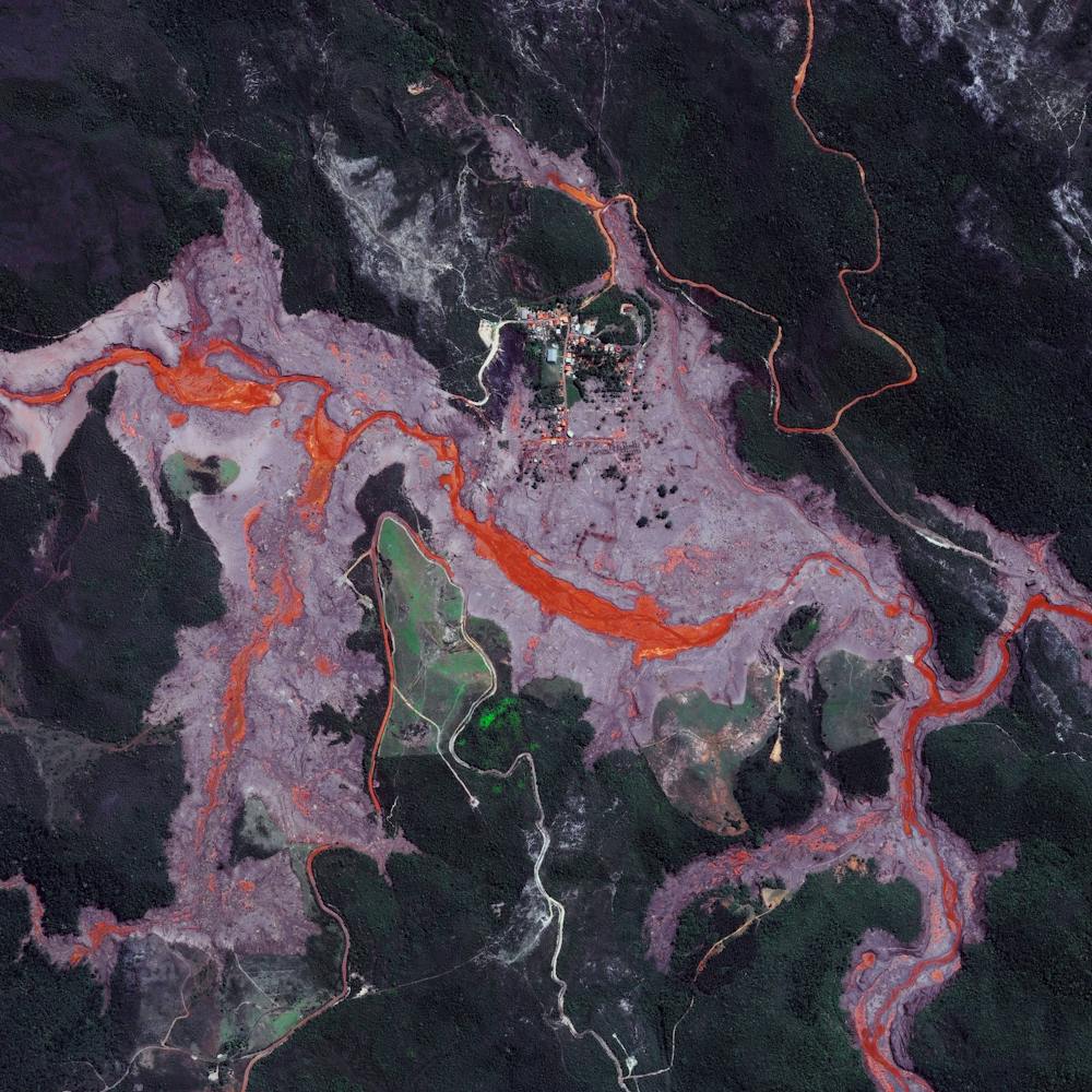
Brazilian Mining Waste Disaster
-20.119722°, -44.121389° - Brumadinho, BrazilLast Friday, a tailings dam collapsed at an iron ore mine in Brumadinho, Brazil, spilling out more than 3 billion gallons (12 billion liters) of red mud and debris. Click the image below to see the areas around the dam before and after its collapse.Homes, cars, buses and other structures were engulfed by the sludgy spill, and the region’s entire ecosystem is expected to be impacted by the contaminants in the tailings — which include waste rock and other residue left over after ore extraction. As of today, media sources are reporting at least 99 people have died and more than 270 are missing.
Maxar Technologies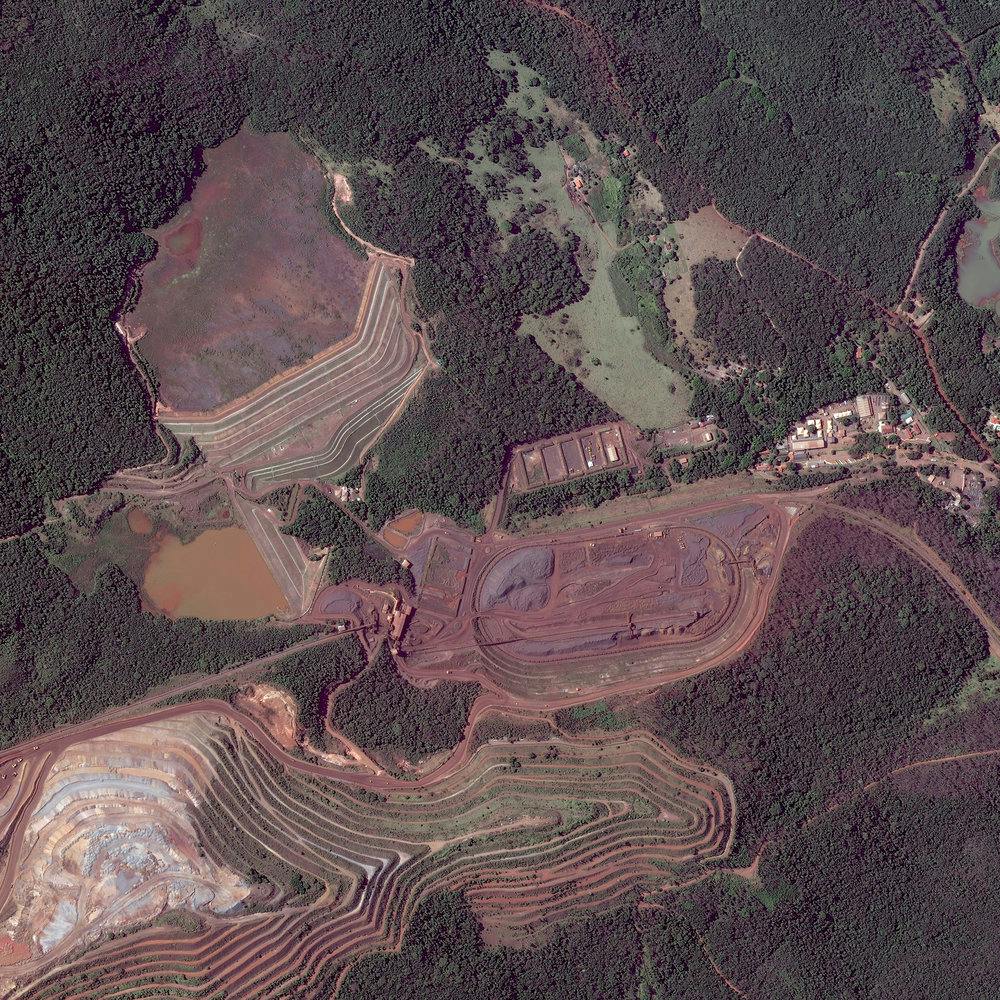
Brick Kilns
23.767575°, 90.318299° - Dhaka, BangladeshKilns for firing and making bricks are scattered across the landscape in Dhaka, Bangladesh. Almost all bricks in the country are made using a 150-year-old process where soil is mixed with water, formed into bricks using wooden molds, left to dry in the sun, and then burned in these orange, traditional kilns. As the widespread use of old kilns has hampered air quality in the country, local groups and the government have been working to increase the use of "clean" brick kilns with more sustainable technology.
Maxar Technologies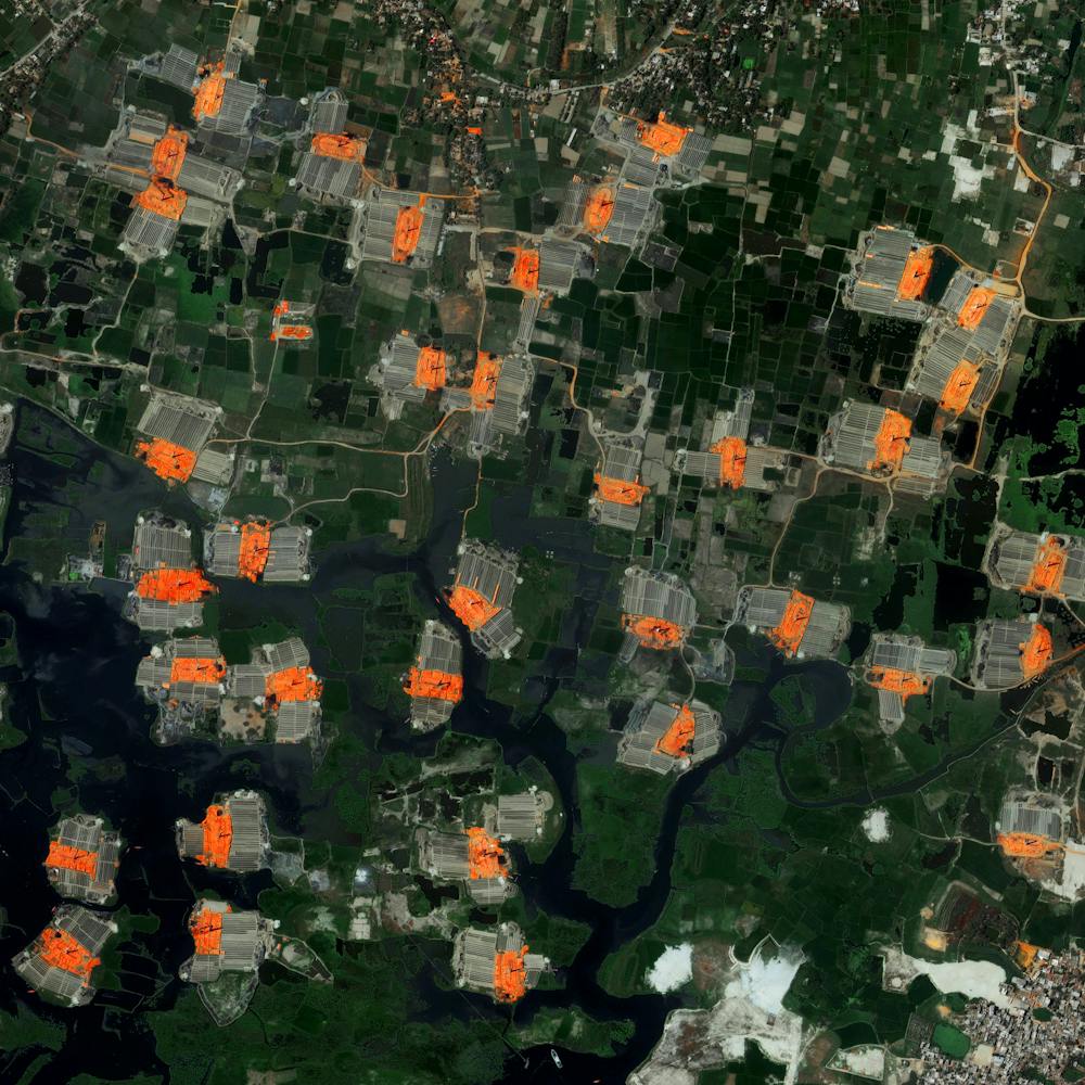
Brighton Pier
50.816388°, -0.137253° - Brighton, EnglandBrighton Pier, also known as Palace Pier, is constructed off the coast of the English city of Brighton. Extending 1,719 feet (524 meters) into the English Channel, the structure contains numerous restaurants, rides, and roller coasters.
Maxar Technologies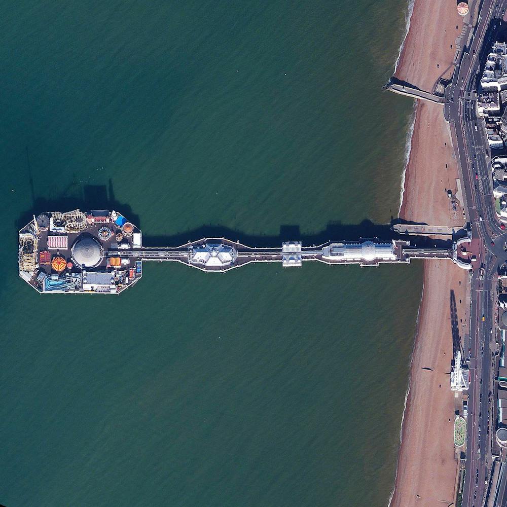
Brock Reservoir
32.716000°, -115.036000° - Gordons Well, California, USAThe Brock Reservoir - located near Gordons Well, California, USA - is used to supply water to nearby farmers via the All-American Canal. Compared to other reservoirs, Brock’s capacity is relatively small with storage for only 2,600 million US gallons. Since 2013, reservoirs across the state of California has experienced a significant reduction in water levels, with more than 80% of land experiencing severe to exceptional drought.
Maxar Technologies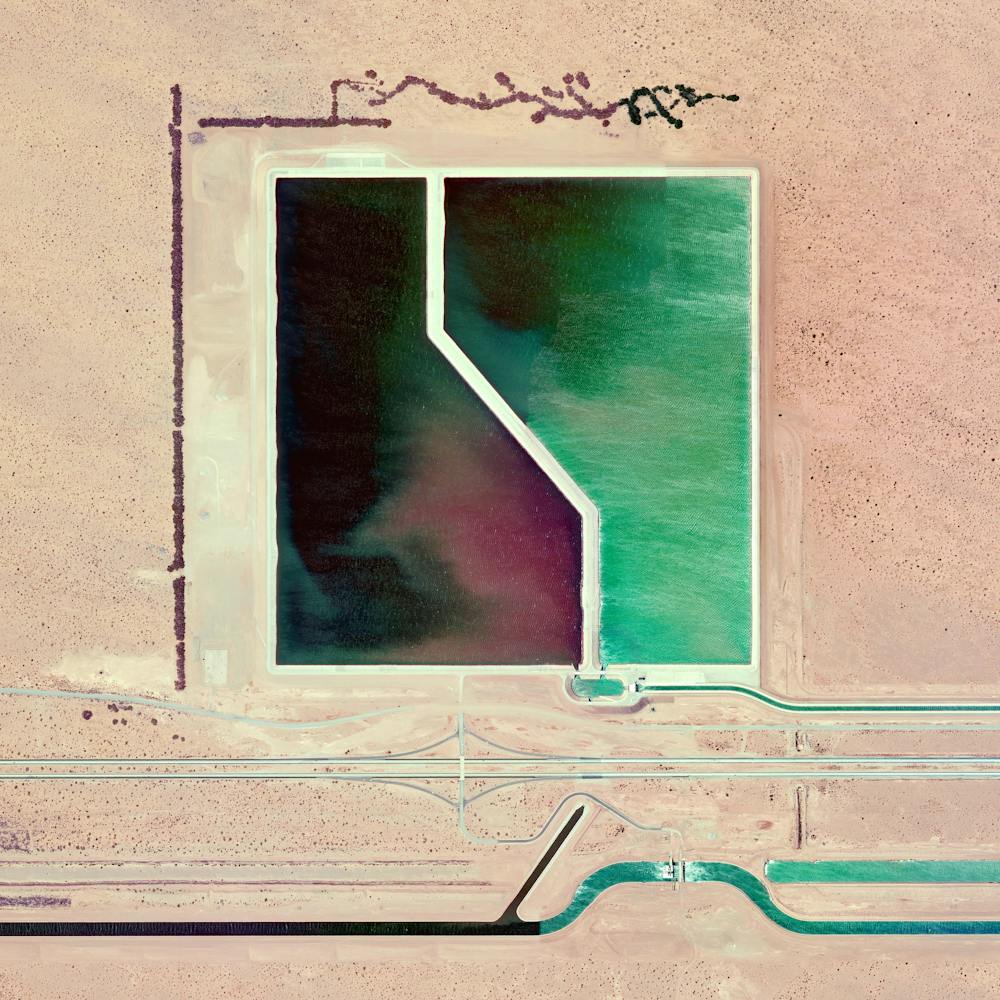
Brøndby Haveby
55.637185°, 12.399623° - 55.637185°, 12.399623°Brøndby Haveby is an associated community located just outside of Copenhagen, Denmark. Houses with large front yards are centered around cul-de-sacs, providing urban dwellers the opportunity to live outside the city and grow small subsistence or hobby crops during the summer months.
Maxar Technologies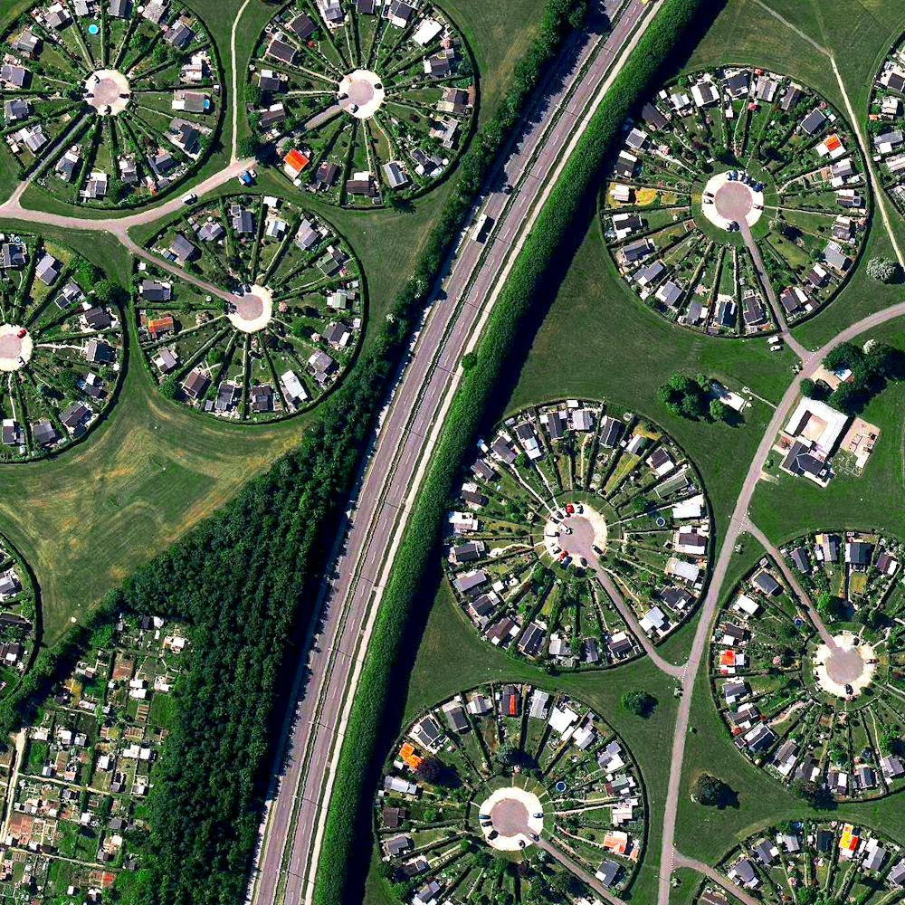
Brussels
50.855457°, 4.377279° - Brussels, BelgiumBrussels is home to 1.2 million residents and serves as the capital of Belgium.
Maxar Technologies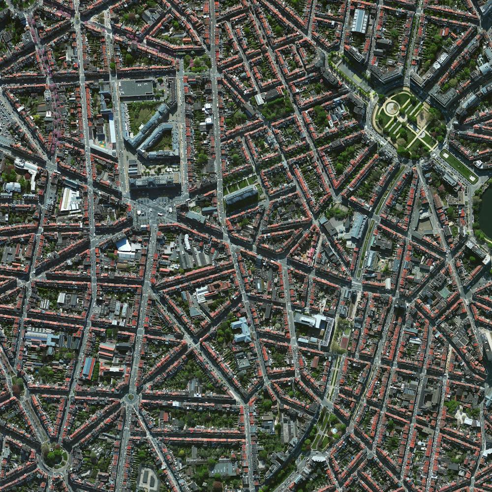
Budapest
47.518667°, 19.054139° - Budapest, HungaryBudapest is the capital of and most populous city in Hungary, as well as one of the largest cities in the European Union. It is home to more than 1,750,000 people and the birthplace of Ernő Rubik, inventor of the Rubik’s Cube. The Danube River enters Budapest from the north and encircles several islands, including Margaret Island, which can be seen at the top of this Overview.
Maxar Technologies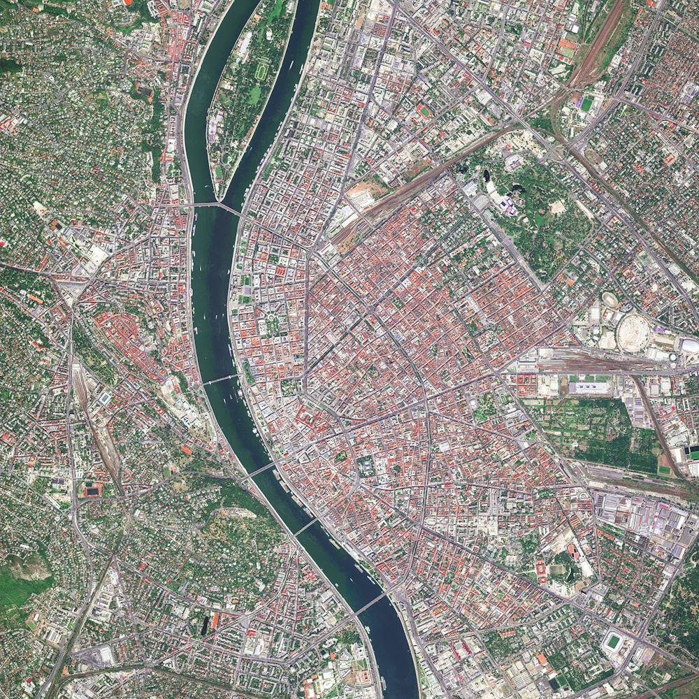
Burj Khalifa
25.197139°, 55.274111° - Dubai, United Arab EmiratesStanding at 2,717 feet (828m), the Burj Khalifa in Dubai, UAE is the tallest building in the world (and casts quite a long shadow!). The design of the 163-floor structure is an abstraction of the Hymenocallis, a type of desert flower that has long petals extending from its center. The building has been very well received since it opened in 2010; however, its construction was very controversial as it was built primarily by workers from South Asia and East Asia who earned low wages and were housed in abysmal conditions.
Maxar Technologies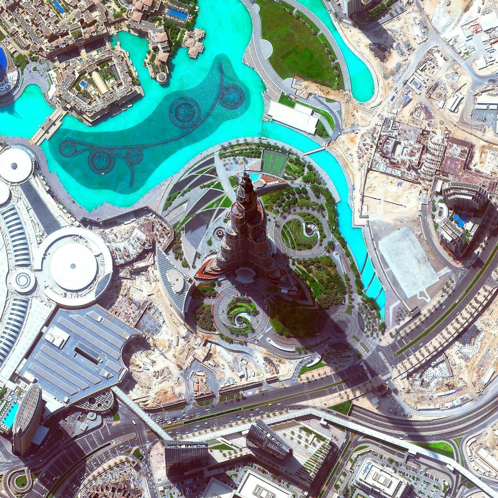
Burning Man
40.786944°, -119.204444° - Black Rock City, Nevada, USAOver the next few days, thousands of people from around the world will head to the desert in Nevada, USA to construct Black Rock City. Laid out in a grid plan with radiating avenues named after the numbers on a clock, the city serves as home to roughly 60,000 people for Burning Man, an annual week-long event. Burning Man is described as an experiment in community, art, self-expression, and radical self-reliance. Additionally residents in Black Rock City practice one of the event's key principles of ‘Leave No Trace’ – meaning significant efforts are taken to make sure as the city is disassembled in the days following the festival, the desert returns to its original state.
Maxar Technologies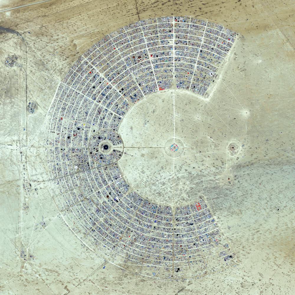
Cádiz
36.533694°, -6.297139° - Cádiz, SpainCádiz is an ancient port city surrounded by the sea in southwest Spain. Because the city was constructed upon a spit of land that cannot support high-rises, its skyline has not substantially changed since medieval times. A portion of the “Old City” — an area characterized by narrow winding alleys connecting large plazas and markets — is seen in this Overview.
Maxar Technologies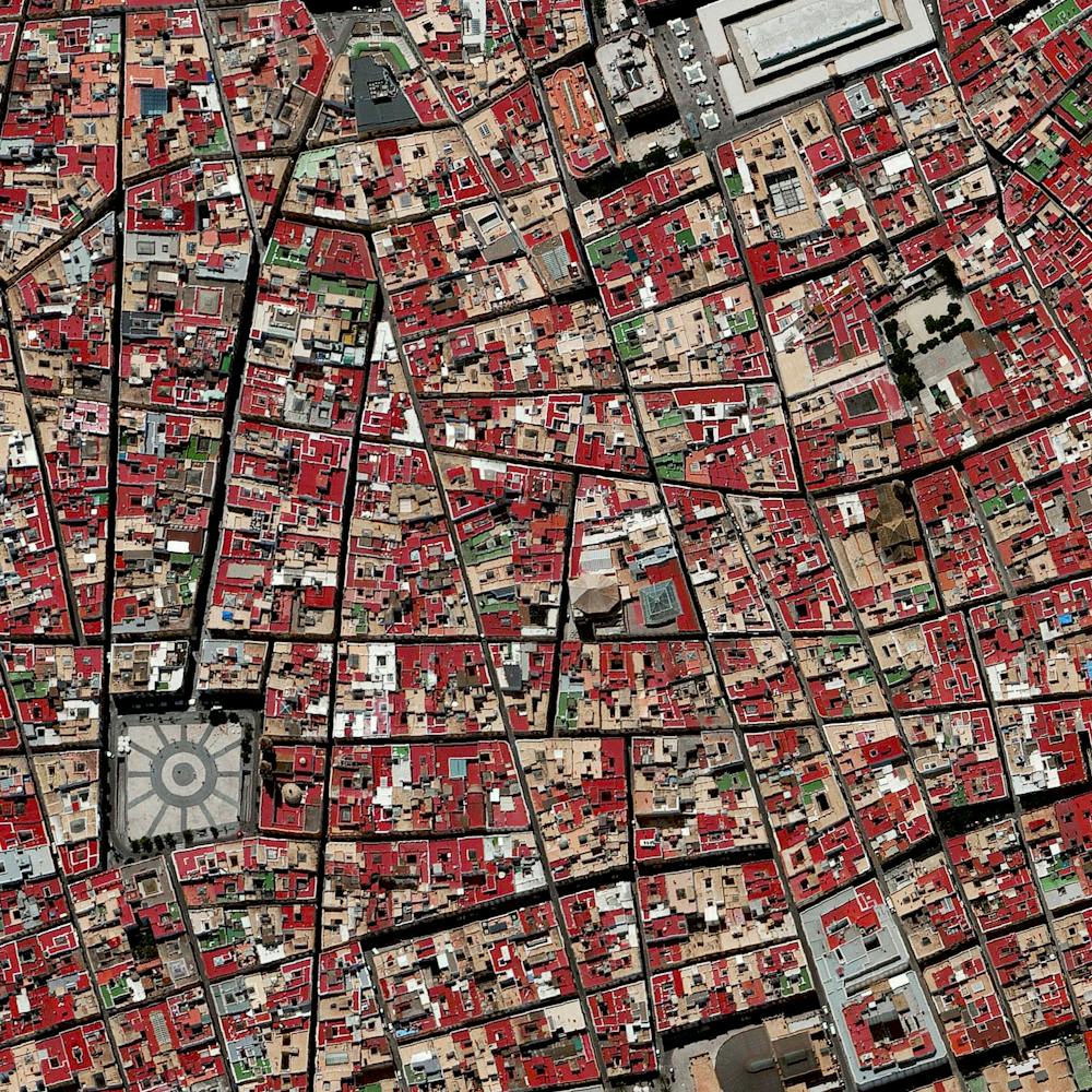
Cadiz Ranch
34.494638°, -115.500469° - Mojave Desert, California, USACadiz Ranch in Essex, California is located in the middle of the Mojave Desert. The organic farm grows lemons, table grapes (dried and turned into raisins) and squash on more than 300 acres of irrigated desert. This is made possible by seven wells that pump 2,000 gallons of water per minute at all times from an underground aquifer - a layer of water-bearing permeable rock from which water can be extracted.
Maxar Technologies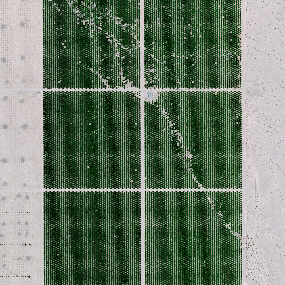
Caiji Co
31.205285°, 85.434498° - China’s Tibet Autonomous RegionPictured here is Caiji Co, a body of water in the Ngari Prefecture of China’s Tibet Autonomous Region. At one point Ngari was the heart of the ancient kingdom of Guge, and later along with Ü and Tsang, composed Ü-Tsang, one of the traditional provinces of Tibet.
Maxar Technologies
Calbuco Volcano eruption
-41.222173°, -72.567814° - Ensenada, ChileThe Calbuco Volcano in southern Chile is spewing ash again today, following two massive eruptions last week. Chilean authorities stated that the initial eruptions released approximately 210 million cubic meters of ash into the air. Striking infrared satellite images taken in recent days show the town of Ensenada, located at the based on the volcano, covered in a thick layer of gray dust.
Maxar Technologies
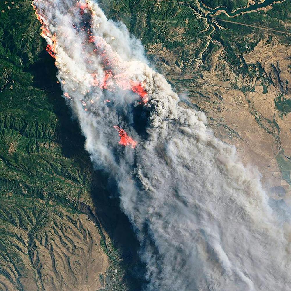
California Wildfires
0.654829°, -122.622173° - California, USAThis image of the Carr and Ferguson wildfires in California was taken aboard the International Space Station by European Space Agency astronaut Alexander Gerst on August 3rd. The Carr Fire, which was first reported July 23rd, has burned more than 261 square miles (676 sq. km) in Shasta and Trinity counties and is currently the sixth-most destructive fire in California’s history. The Ferguson Fire began July 13th and has since burned 147 square miles (382 sq. km) in the Sierra and Stanislaus National Forests. Both fires have been attributed to warming temperatures and unprecedented dryness.
NASA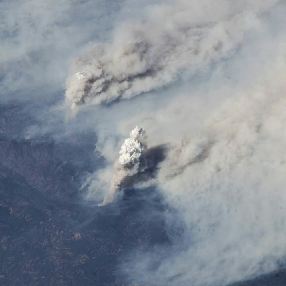
California Wildflower Superbloom
33.674278°, -117.438973° - Lake Elsinore, California, USAWildflowers blanket the hills around Lake Elsinore, a city in southern California. This explosion of poppies and other blossoms — called a "super bloom" — occurs when a rainy fall and winter are followed by cold temperatures that lock moisture in the ground. This year's super bloom is southern California's biggest in years, which has attracted droves of locals and tourists to the hills.
Maxar Technologies
Calipatria Fields
33.116410°, -115.627270° - Calipatria, California, USAAgricultural development is seen in Calipatria, California, USA. At an elevation of 180 feet (55 m) below sea level, the city has the lowest elevation in the western hemisphere.
Maxar Technologies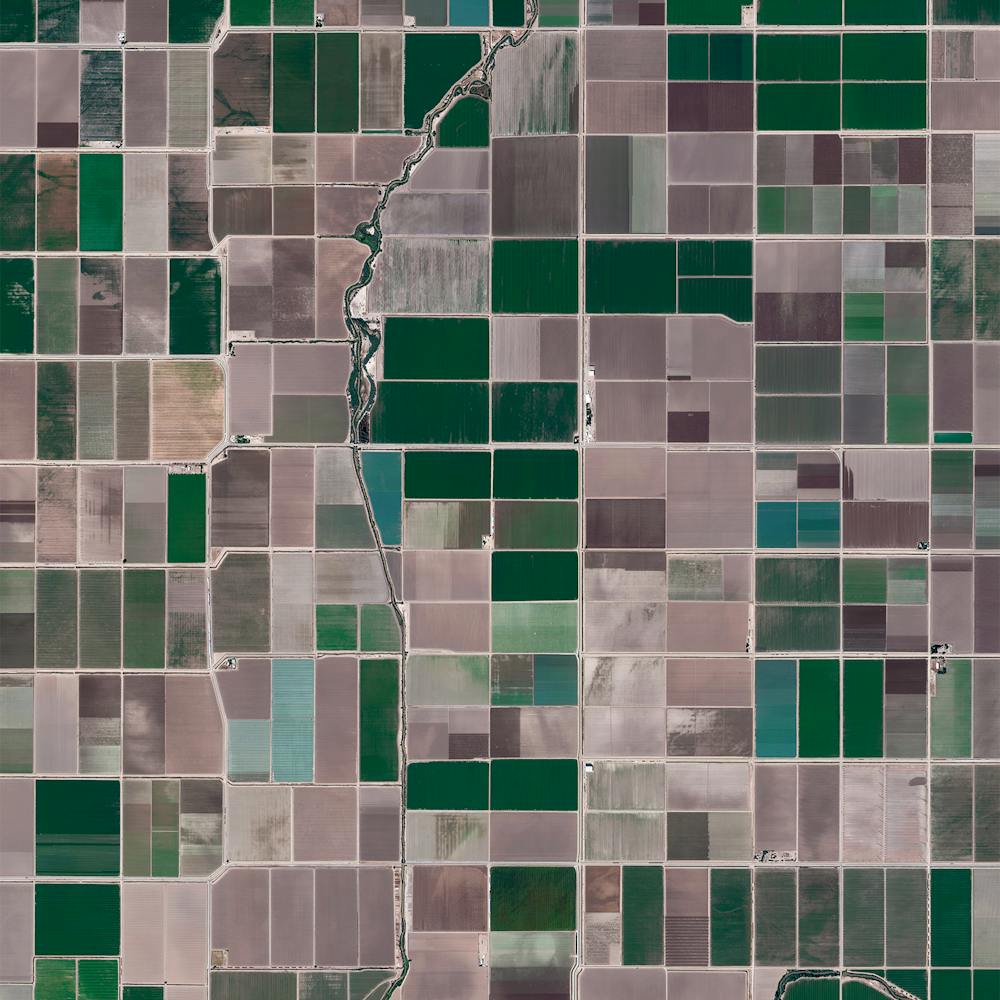
Camargue Salt Ponds
43.387500°, 4.804000° - 43.387500°, 4.804000°Vibrantly colored salt evaporation ponds are seen adjacent to Port-Saint-Louis-du-Rhône in southern France. This region — known as the Camargue — lies between the Mediterranean Sea and the two arms of the Rhône River delta, forming a natural series of brine lagoons. Salt has been produced in this region for thousands of years and is sought-after worldwide for its superior quality.
Maxar Technologies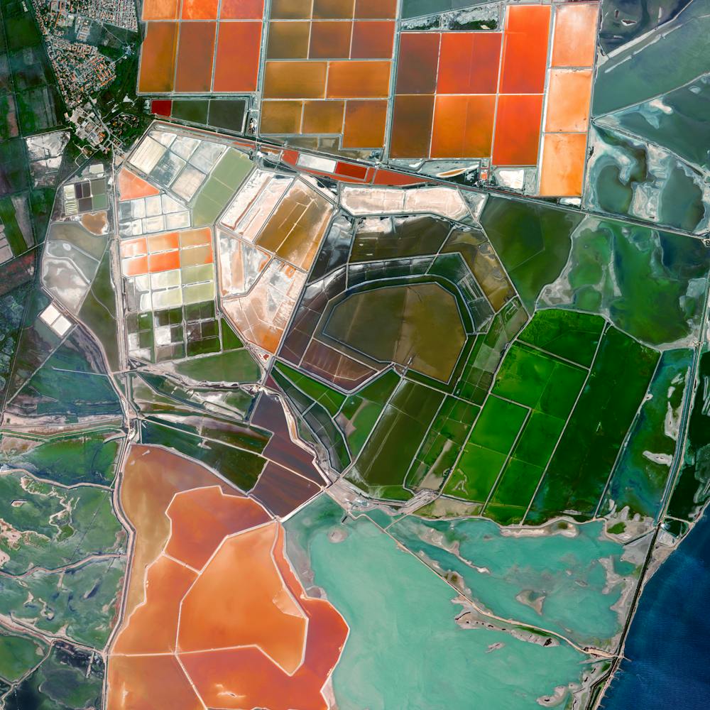
Camp Wildfire
39.759259°, -121.597808° - California, USAThe Camp Fire, which is currently burning in Northern California, has become the deadliest wildfire in state history with a death toll of 42 as of this morning. The blaze has scorched more than 117,000 acres (47,000 hectares), destroyed more than 7,000 structures and forced 52,000 people to evacuate their homes. The fire is roughly 30 percent contained at the moment.
NASA