Explore
 Shop
Shop About
About Search
Overview Index
Warracknabeal
-36.255902°, 142.395859° - Victoria, AustraliaWarracknabeal is a town located in the Australian state of Victoria, roughly 205 miles north-west of Melbourne. The small town of 2,745 people has a yearly Easter tradition called the “Y-Fest” that features activities such as a street parade, golf tournament, and waterski spectacular.
Nearmap
Washington Monument
38.889469°, -77.035258° - Washington D.C, USATo celebrate Presidents Day in the United States, here is the Washington Monument - an obelisk located on the National Mall in Washington, D.C. Standing 555 feet 5 1/8 inches (169.294 m) tall, the structure was built to commemorate George Washington, the first President of the United States. The structure was completed in 1885; is made out of marble, granite, and bluestone gneiss; and is recognized as the world's tallest stone structure.
Nearmap
Washington Wastewaster Pools
45.574722°, -122.424028° - Camas, Washington, USAAerobic digesters agitate wastewater at a sewage treatment plant in Camas, Washington. This process is designed to reduce the volume of sewage sludge in the water, making it suitable for subsequent use. After it has been treated, the water is discharged from the plant into the Columbia River.
Nearmap
Washington, D.C,
38.890556°, -77.020278° - Washington, D.C, USAWashington, D.C.'s L'Enfant Plan was developed in 1791 by Major Pierre Charles L'Enfant for George Washington, the first President of the United States. L’Enfant designed a compass-aligned grid for the city’s streets, with intersecting diagonal avenues that were later named after the states of the union. The diagonal avenues also intersect with the north-south and east-west streets at circles and rectangular plazas in order to create more open, green spaces. Lastly, L'Enfant laid out a 400 foot-wide (122 meter) garden-lined “grand avenue” - what is now know as the National Mall – that connects the US Capitol Building, the Washington Monument, and the Lincoln Memorial (the latter two are visible at right in this Overview).
Maxar Technologies
Washington, D.C. Tidal Basin
38.887333°, -77.039389° - Washington, D.C., USAIndependence Avenue encircles a section of the Tidal Basin Reservoir in Washington, D.C. Originally named South B Street, this major roadway was constructed between 1791 and 1823 and passes by many of the city’s monuments, including the U.S. Capitol Building, Washington Monument and Lincoln Memorial. In the spring, it is also a popular route for viewing Washington D.C.’s cherry blossoms, some of which can be seen in this Overview.
Nearmap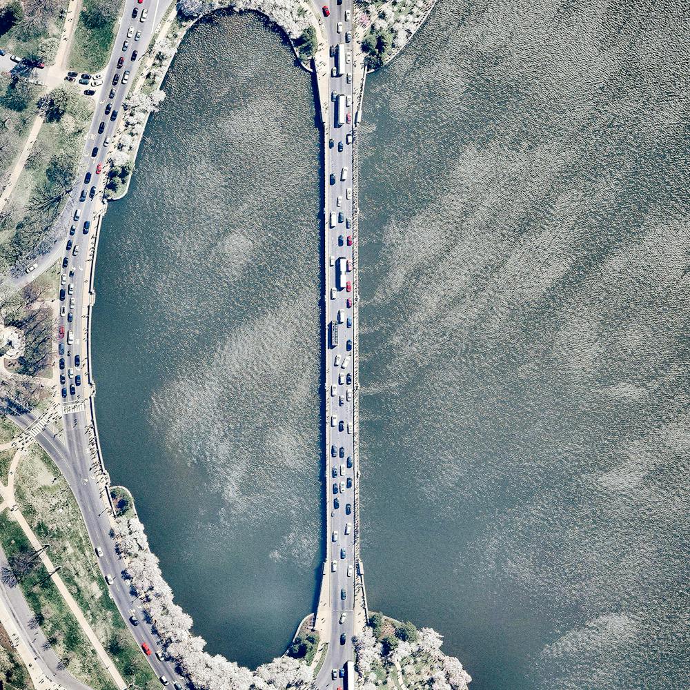
Wat Phra Dhammakaya
14.082361°, 100.647750° - Khlong Luang, ThailandWat Phra Dhammakaya is a Buddhist temple in the Khlong Luang District of Thailand, roughly 30 miles north of Bangkok. Established in 1970, the temple uses modern methods and technology to encourage a revival of traditional Buddhist values. Its methods have stirred controversy in Thailand and even caused the ruling military junta to temporarily lock it down in 2017.
Maxar Technologies
Whakaari / White Island
-37.516667°, 177.183333° - Bay of Plenty, New ZealandWhakaari, also known as White Island, is an active stratovolcano, situated 48 km (30 mi) from the North Island of New Zealand in the Bay of Plenty. Whakaari is New Zealand’s most active volcano, and has been built up by continuous eruptions over the past 150,000 years. The island is approximately 2 km (1.2 mi) in diameter and rises to a height of 321 m (1,053 ft) above sea level.
Maxar Technologies
Willie Creek
-17.762556°, 122.237278° - Broome, Western AustraliaWillie Creek is a protected tidal estuary roughly 10.5 miles (17 km) north of Broome, Western Australia. The creek’s calm, nutrient-rich waters make it an ideal habitat for the Pinctada maxima oyster, which produces world-renowned pearls.
Nearmap
Windsor Castle
51.483333°, -0.604167° - Windsor, England, UKToday Queen Elizabeth II celebrates her 90th birthday. Windsor Castle, located in English county of Berkshire and seen in this Overview, is one of her official residences and her preferred weekend destination. More than 500 people live and work in Windsor Castle, making it the largest inhabited castle in the world.
Maxar Technologies
Winter Garden Driving Range
28.444139°, -81.633694° - Winter Garden, Florida, USAA large circular driving range is seen here at the Orange County National Golf Center and Lodge in Winter Garden, Florida. Including putting greens and a short-game practice area, the facility covers 42 acres (17 hectares). It is visited by many golf professionals every year; in fact, Tiger Woods once used the driving range to film a commercial with Nike.
Nearmap
Woodford Bay
-33.829873°, 151.173957° - New South Wales, AustraliaSailboats are moored in Woodford Bay, New South Wales, Australia. Thousands of boats like the ones seen here are stationed in the channels and around the islands in the greater Sydney area. Wherever you are in the world, we hope you have a peaceful, fantastic weekend!
Nearmap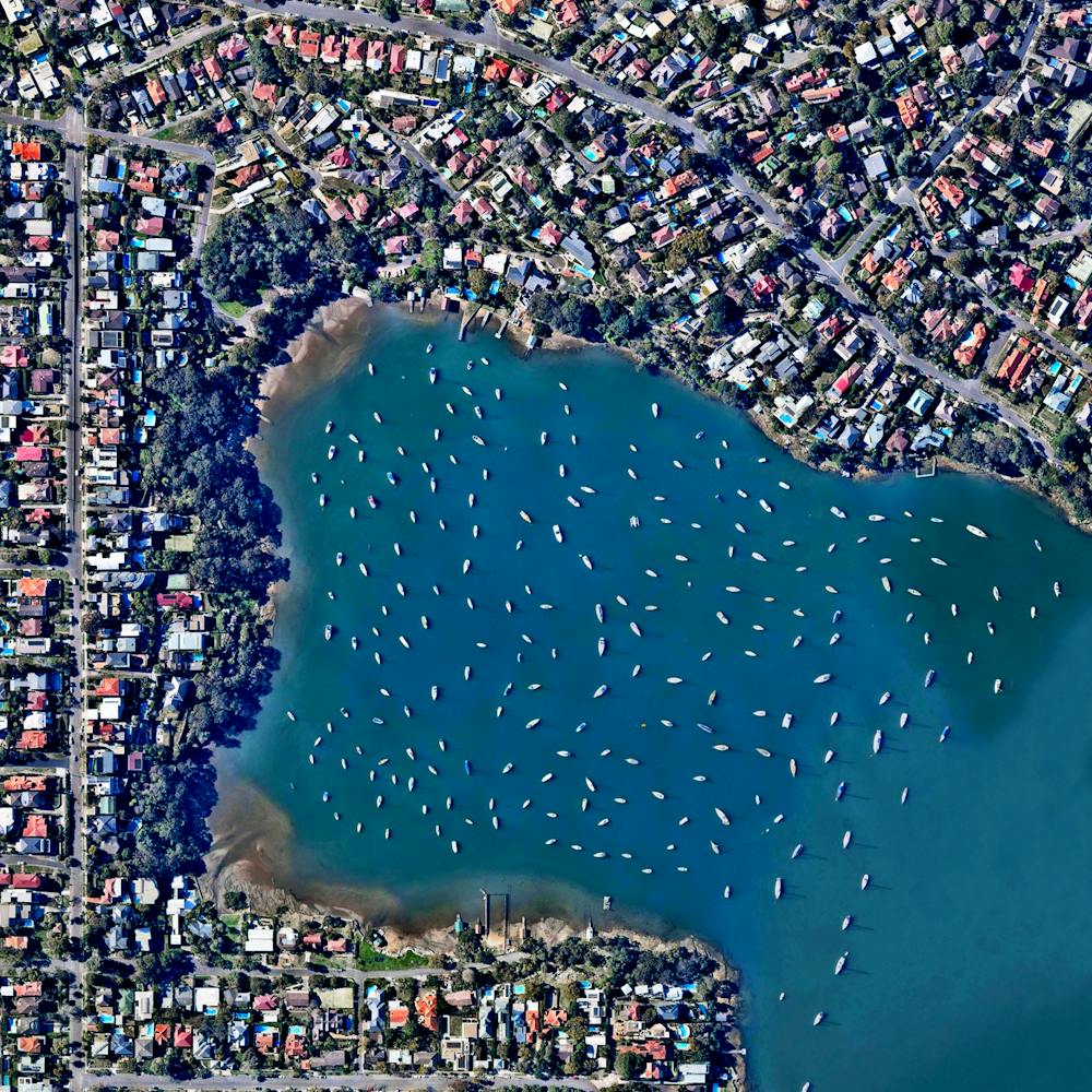
Woodford Bay Boats
-33.829861°, 151.173972° - Woodford Bay, New South Wales, AustraliaDozens of sailboats are moored in Woodford Bay, New South Wales, Australia. Surrounding Woodford Bay is Longueville, a small residential suburb of Sydney, located about 5 miles (8 km) northwest of the city’s central business district. Thousands of boats like the ones seen here are stationed in the channels and around the islands in the greater Sydney area.
Nearmap
World Trade Center Aftermath
40.711596°, -74.013218° - New York, New York, USAThis overview was captured above Ground Zero in downtown Manhattan on September 23, 2001. In the face of such darkness and destruction, we hope we can use this memory as an opportunity to recognize how essential it is to foster an appreciation and love for our fellow man.
NOAA
Wrigley Field
41.948387°, -87.655326° - Chicago, Illinois, USAWrigley Field is home to the Chicago Cubs baseball team and is the second-oldest active major league ballpark (after Fenway Park in Boston) with its first game played in 1916. "The Friendly Confines" are known for its ivy-covered brick outfield wall and was the last major league ballpark to have lights installed for night games in 1988.
Maxar Technologies
Wrigley Field
41.948333°, -87.655556° - Chicago, Illinois, USAIt's Father's Day here in the United States, so I thought it was fitting to share an Overview of my dad's favorite place - Wrigley Field. The stadium is home to the Chicago Cubs and is the second-oldest active major league ballpark (after Fenway Park in Boston) with its first game played in 1916. known for its ivy-covered brick outfield wall and was the last major league ballpark to have lights installed for night games in 1988.
Maxar Technologies
Xiluodu Dam
28.259850°, 103.649500° - Xiloudu, ChinaWater from the Jinsha River surges through the Xiluodu Dam near Xiluodu, China. Arch dams like this one are designed so that the force of the contained water presses against the arch, compressing and strengthening the structure by pushing it into its foundation. At 937 feet (286 meters), the dam in Xiluodu is the fourth tallest in the world and is primarily used for hydroelectric power generation.
Maxar Technologies
Yuanyang Rice Terraces
23.159391°, 102.753863° - Yuanyang County, ChinaRice paddies cover the mountainsides of Yuanyang County, China. Constructed in “steps” by the Hani people for the last 1300 years, the slope of the terraces varies from 15 to 75 degrees with some having as many as 3,000 steps! The stunning colors that you see here are indeed real and result from the presence of water and certain plants within the terraces.
Maxar Technologies
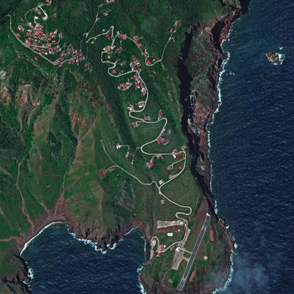
Zion's Hill
17.643056°, -63.226944° - 17.643056°, -63.226944°Zion’s Hill, also known by its former name Hell’s Gate, is a town on the Dutch Caribbean island of Saba. It is the first town one reaches after leaving Juancho E. Yrausquin Airport, which has the shortest commercial runway in the world at 1,312 feet (400 m) long. With a land area of just 5 square miles (13 square km) and about 2,000 inhabitants, Saba is the smallest territory by permanent population in the Americas.
Maxar Technologies