Explore
 Shop
Shop About
About Search
Overview Index
Salt Lake City, Utah
40.776783°, -112.060569° - Salt Lake City, Utah, USASalt Lake City is the capital and most populous municipality in the state of Utah, with about 1.2 million residents in its metropolitan area. It was founded in 1847 by followers of the Church of Jesus Christ of Latter-day Saints, who sought to escape persecution they experienced living in the east. As shown in this Overview, the city has a distinct north-south east-west grid system, which was laid out by church leader Brigham Young using what was called the "Plat of Zion" or the "Mormon Grid."
Nearmap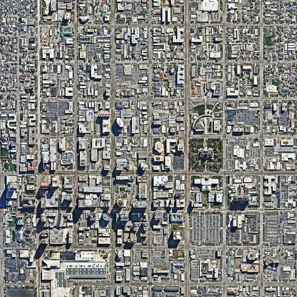
Salt Ponds
37.495364°, -122.160180° - San Francisco, California, USAA recent figure estimates that 80% of the San Francisco Bay wetlands area - approximately 16,500 acres - have been developed for salt mining. The ponds get their particular, vibrant colors from the micro-algae that live there and the species' tolerance to salinity. Areas that have a bright red hue are caused by the algae Dunaliella, which thrives in water with extremely high salt content. For a sense of scale, this Overview shows approximately one half of a square mile.
Maxar Technologies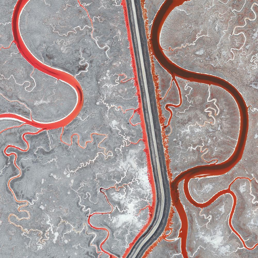
San Alfonso del Mar
-33.350000°, -71.653333° - Algarrobo, ChileThe swimming pool at the San Alfonso del Mar Resort in Algarrobo, Chile is the largest in the world. The pool is more than one thousand meters long (3,323 ft) and contains approximately 250 million liters (66 million gallons) of water! The resort pays $4 million dollars each year to maintain the pool.
Maxar Technologies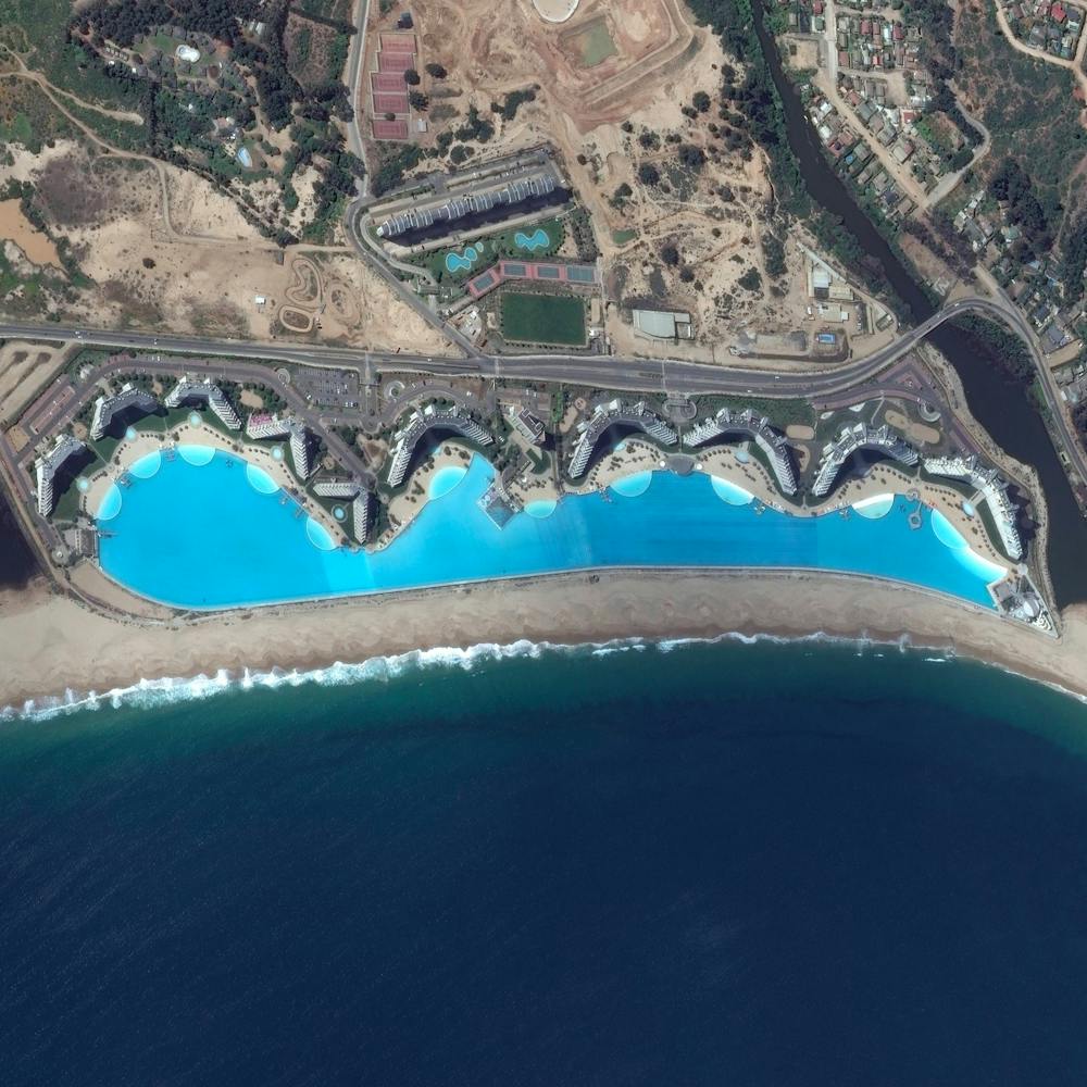
San Cristóbal Volcano
12.703833°, -87.000778° - NicaraguaSan Cristóbal Volcano is the highest and one of the most active volcanoes in Nicaragua. Standing at 5,725 feet (1,745 m), it is located in the northwest corner of the country near the city of Chinandega. San Cristóbal has been consistently active since 1997, including an eruption on Christmas Day in 2012 that caused hundreds of nearby residents to evacuate.
Maxar Technologies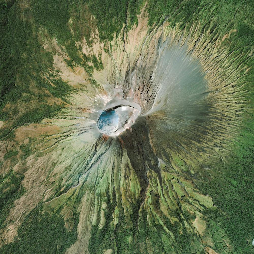
San Francisco Bay Container Ship
37.767035°, -122.417378° - San Francisco Bay, California, USAA ship full of containerized cargo navigates San Francisco Bay, located between San Francisco and Oakland, California. Due to San Francisco's limited real estate, Oakland has served as the primary Bay Area port since the 1960s. The Port of San Francisco handled no containerized cargo in 2017, whereas the Port of Oakland had a throughput of nearly 2.5 million twenty-foot equivalent units (TEUs) that year.
Nearmap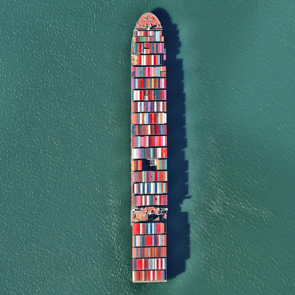
San Francisco Bay Salt Ponds
37.504215°, -122.036887° - California, USASalt ponds are seen on San Francisco Bay in northern California, USA. Here water is channelled into large ponds and exits through natural evaporation. The salt that remains can then be collected. The massive ponds get their vibrant reddish colors from the algae that thrive in the extremely salty water. Approximately 80% of this wetlands area – approximately 16,500 acres – has been developed for salt mining.
Maxar Technologies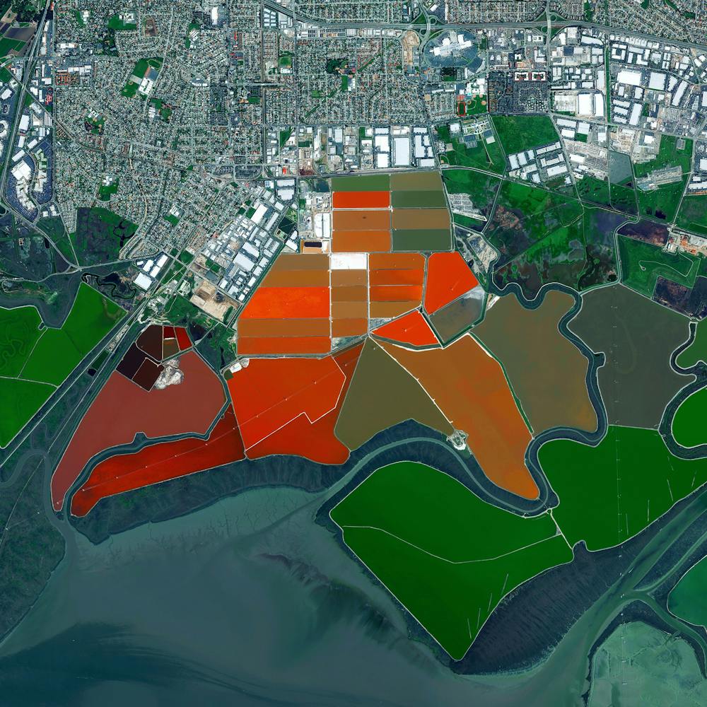
San Francisco International Airport (SFO)
37.618889°, -122.375000° - San Francisco, California, USASan Francisco International Airport is the twenty-first busiest airport in the world by passenger traffic, accommodating more than 50 million passengers every year.
Maxar Technologies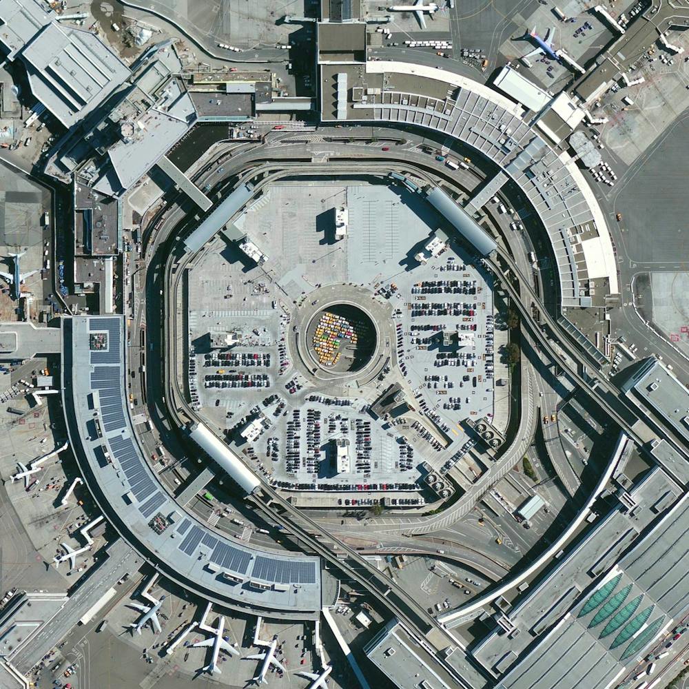
San Juan River
37.206194°, -109.995583° - Utah, USAIn this Overview, the San Juan River is shown meandering through southeastern Utah, not far from Goosenecks State Park. It is a major tributary of the Colorado River and provides drainage to the Four Corners region of Colorado, New Mexico, Utah and Arizona. The San Juan is one of the muddiest rivers in North America, carrying an average of 25 million U.S. tons of silt and sediment each year.
Maxar Technologies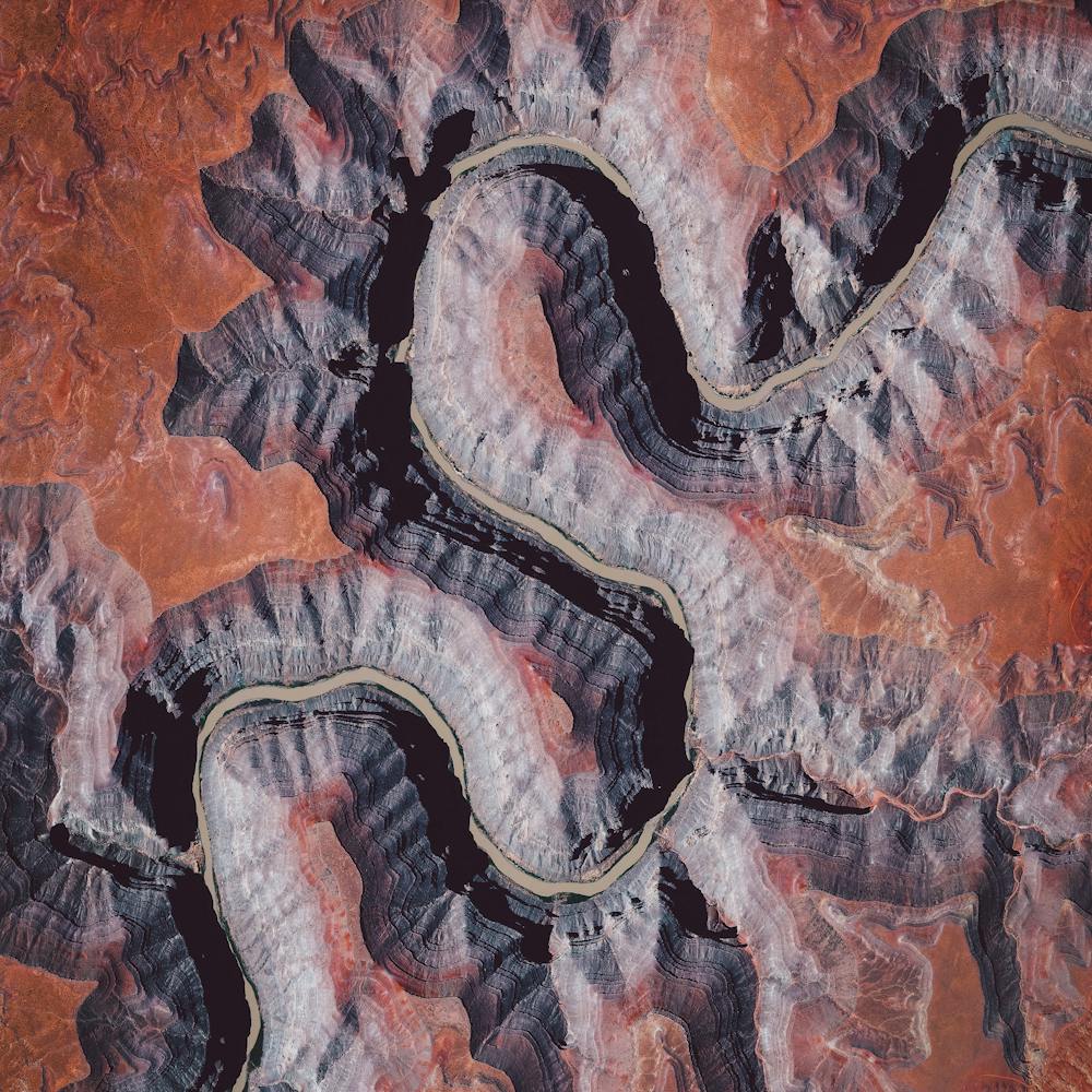
Sand patterns in Salta
-22.821924°, -65.030245° - Salta, ArgentinaSand patterns are seen here in Salta, Argentina. Salta is situated 3780 feet above sea level in the northwest part of the country. The palette of colors in the sand is caused for a variety of reasons. The red occurs from large amounts of iron in the sand that have broken down, and stained the sand a rust color. The black presumably occurs following volcanic activity. The white seen in this Overview is snow covering the tops of the mountains.
Maxar Technologies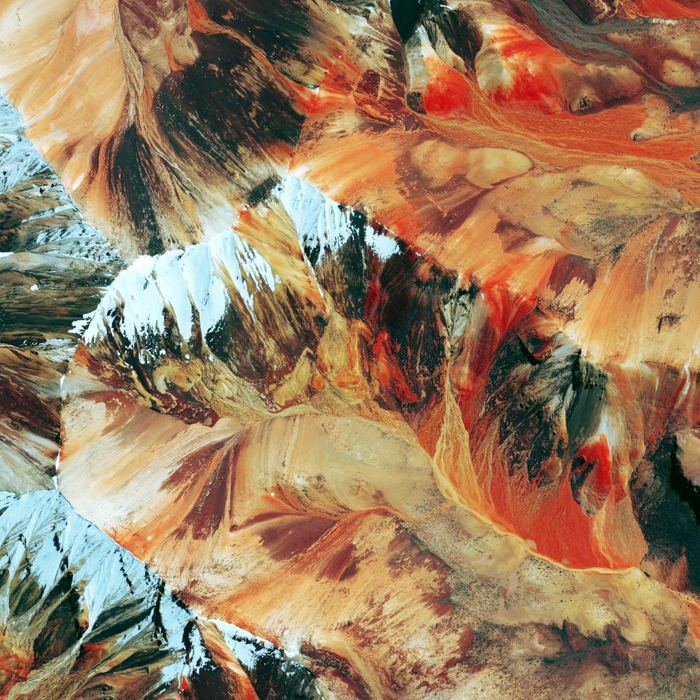
Sandstone formations
34.890479°, -111.754571° - Sedona, Arizona, USASedona, Arizona is encircled by an array of vibrant, red sandstone formations that glow throughout the day and with the setting sun. The Overview here shows the formations around Wilson Mountain, which are visible from the North side of the town.
Maxar Technologies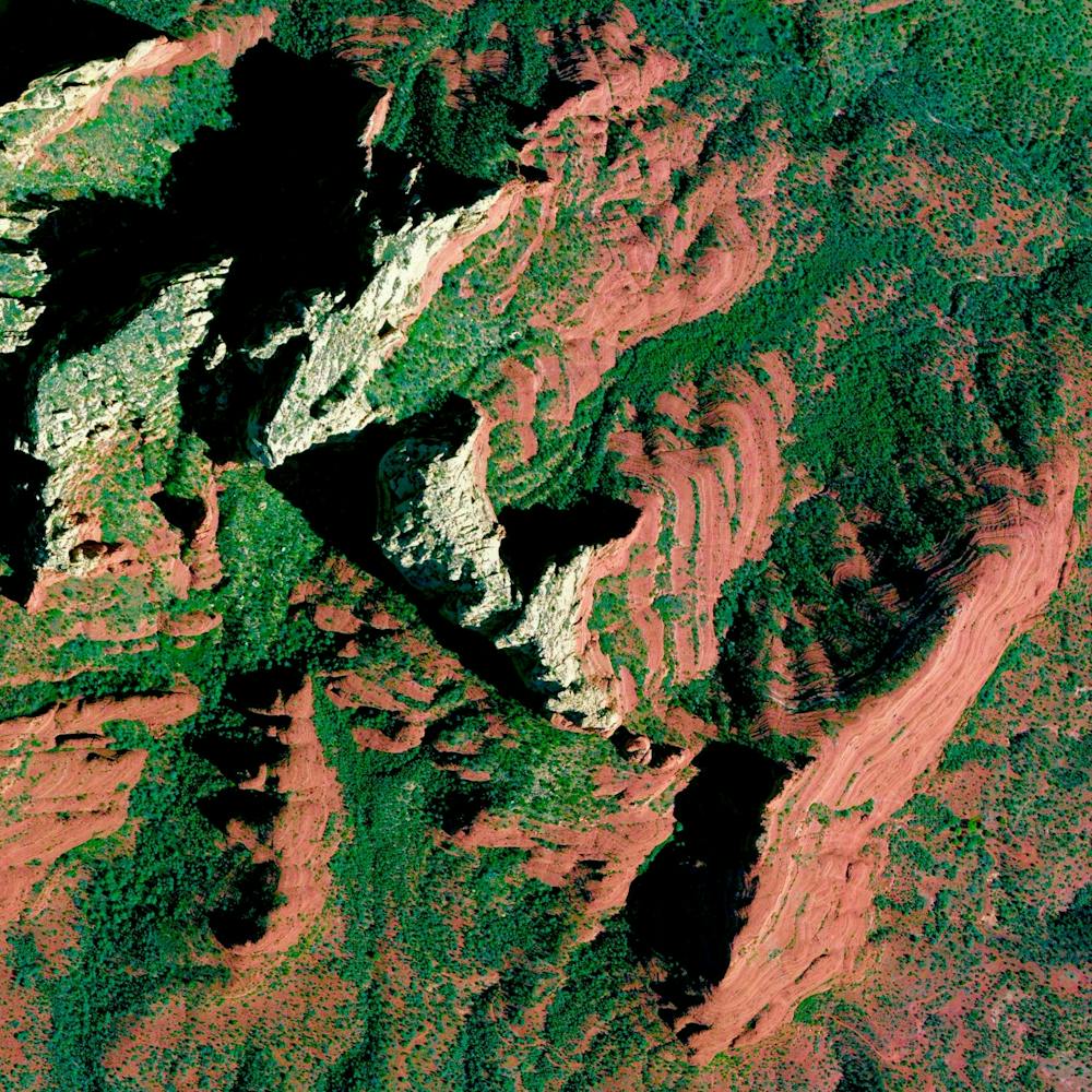
Sant Antoni de Portmany
38.977245°, 1.300852° - Sant Antoni de Portmany, IbizaIbiza is an island located in the Mediterranean Sea off the eastern coast of Spain. Covering 572 square kilometers, Ibiza is roughly 10 times larger than the island of Manhattan in New York City. Sant Antoni de Portmany, the second largest town on the island, is seen here.
Maxar Technologies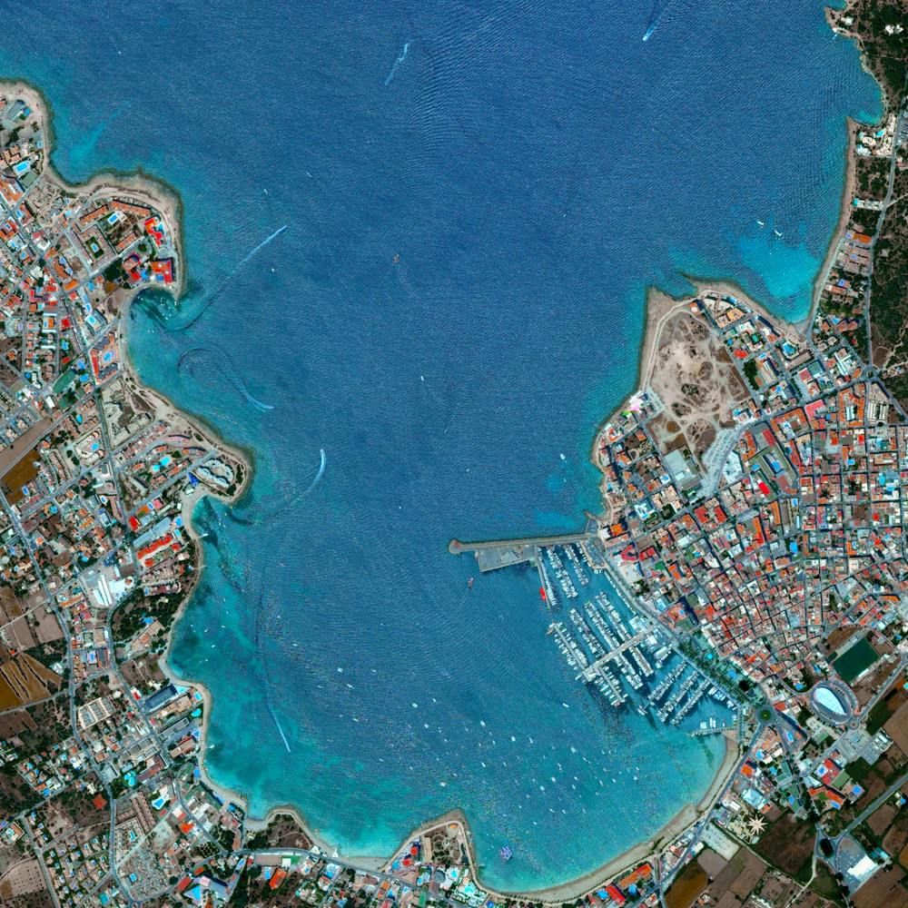
Saronic Gulf Fish Farming
37.609583°, 23.317778° - Saronic Gulf, GreeceCheck out this Overview, which shows a fish farming operation in the Saronic Gulf, just off the eastern tip of Greece’s Peloponnese peninsula. Fish farming — or pisciculture — involves raising fish in tanks or enclosures, usually for food. In 2015, Greece had at least 300 of these farms and raised more than 242 million pounds (109 million kg) of fish and mussels.
Maxar Technologies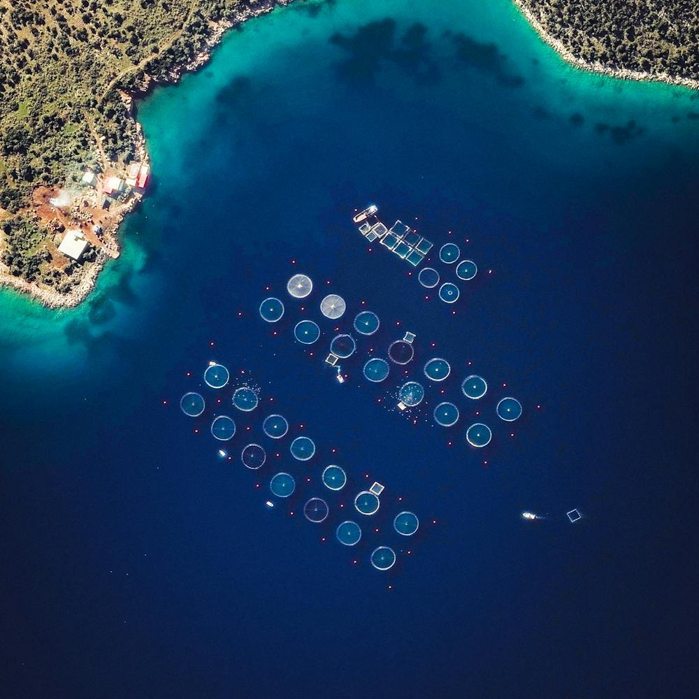
Sarychev Peak
48.091452°, 153.199722° - Kuril Islands, RussiaSarychev Peak is located on Matua Island in the Kuril Islands of Russia. When the volcano erupted on June 11, 2009, the expulsion of debris caused significant interruption to air traffic between east Asia and North America. The eruption was also so great that astronauts aboard the International Space Station were able to photograph the plumes of ash and smoke rising from its cone, as the force of its shock waves dispersed all clouds covering the area.
Maxar Technologies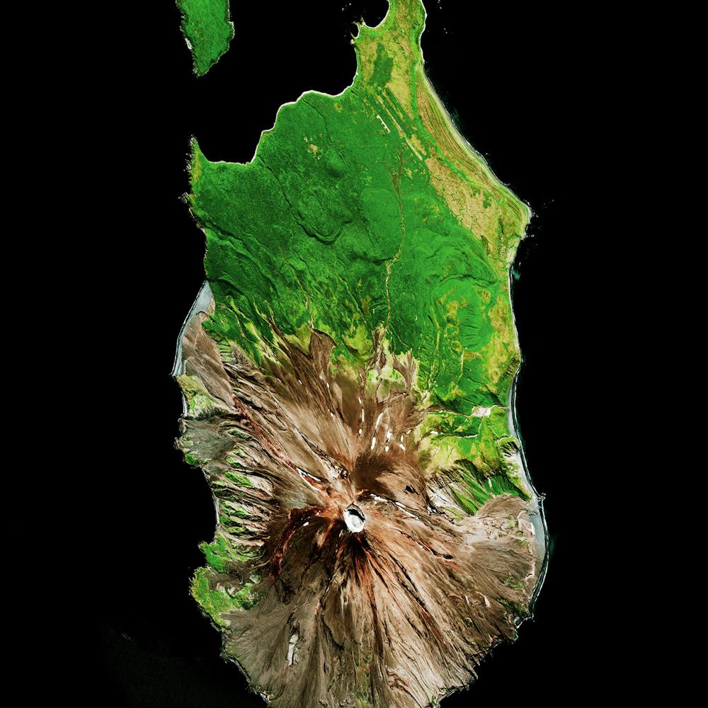
Saskatoon Airplanes
52.169389°, -106.681472° - Saskatoon, Saskatchewan, CanadaSeveral jets are parked outside a hangar at the John G. Diefenbaker International Airport in Saskatoon, Saskatchewan, Canada. With two runways, nine passenger bridges and three ground-loading positions, the airport handles just under 1.5 million passengers per year. By contrast, the busiest airport in Canada (Toronto Pearson International) handles nearly 50 million passengers annually.
Nearmap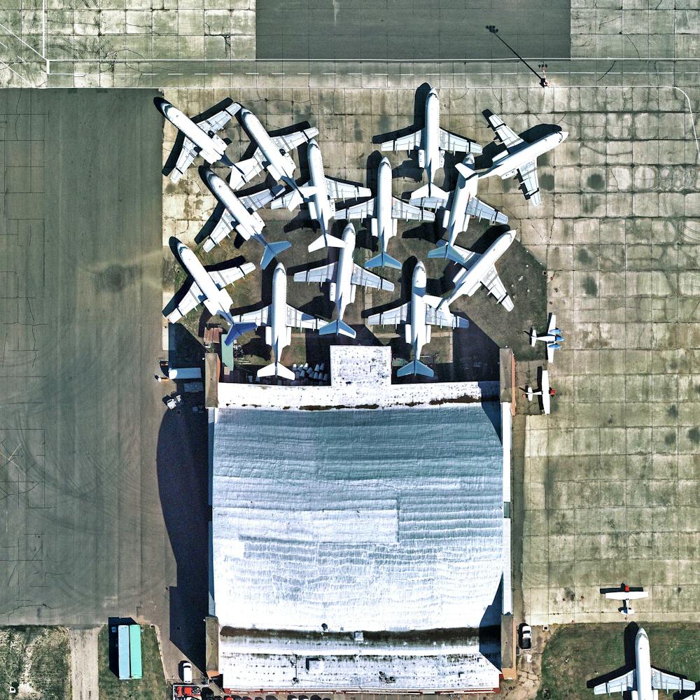
Schönbrunn Palace
48.184865°, 16.312240° - Vienna, AustriaSchönbrunn Palace is a 1,441 room complex that sits upon 435 acres of spectacular gardens in Vienna, Austria. It was here that Mozart gave his first concert to the royal family when he was only six years old.
Maxar Technologies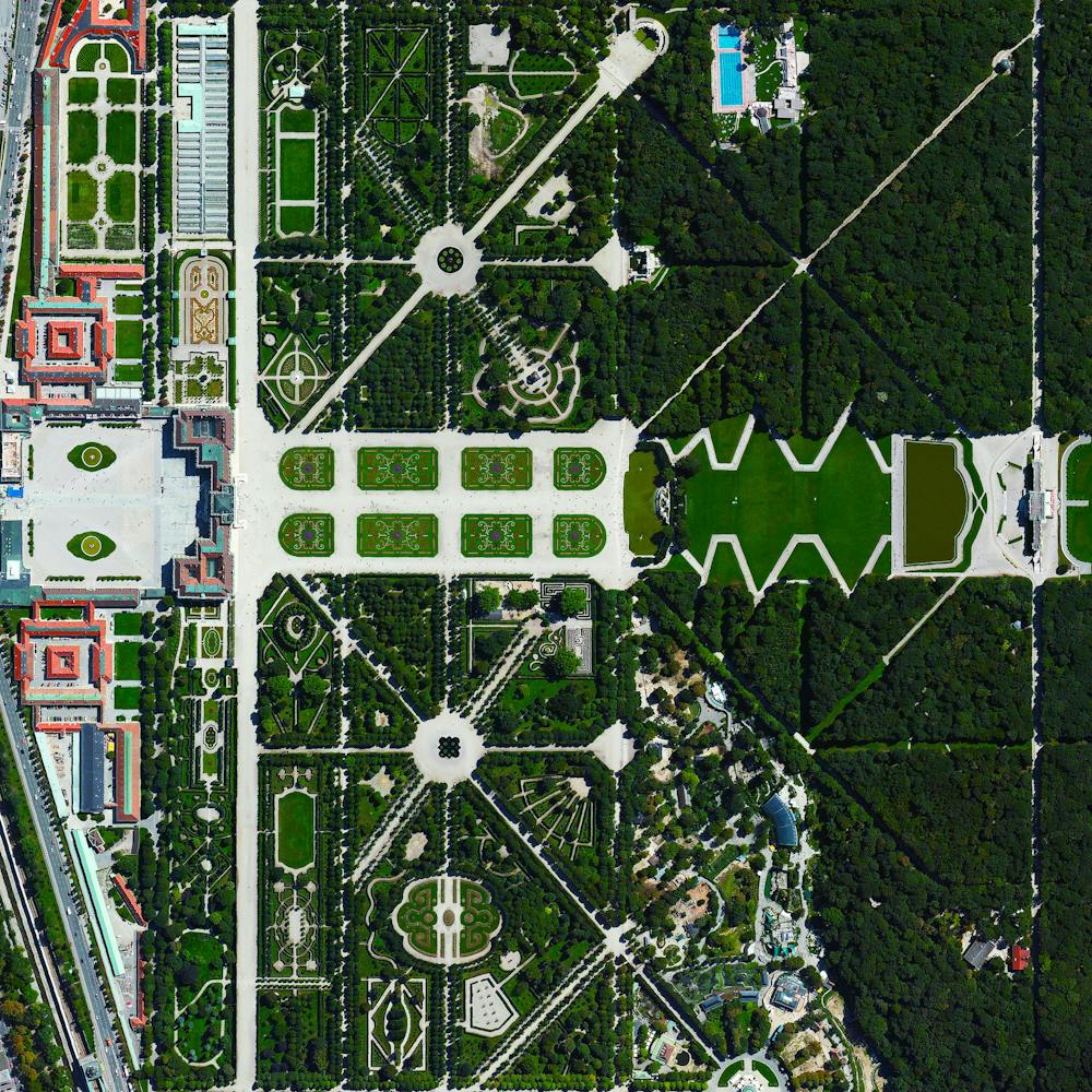
School Bus Assembly Plant
36.189292°, -95.875041° - Tulsa, Oklahoma, USAHundreds of school buses are seen at an assembly plant in Tulsa, Oklahoma, USA. The standard American school bus is 45 feet (13.7 meters) long and has a seating capacity of up to 90 passengers. This particular facility manufactures 50 to 75 buses a day on average.
Nearmap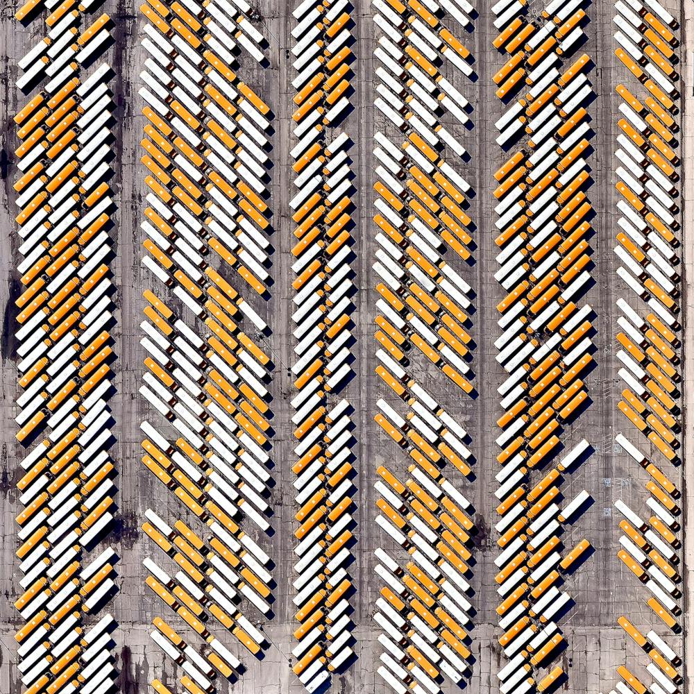
Schwetzingen Palace
49.384167°, 8.570556° - Baden-Württemberg, GermanySchwetzingen Palace is located in the German state of Baden-Württemberg. Built in stages from 1700 until 1750, the grounds of the palace feature ornate gardens that were designed in the styles of the the "French formal garden" and the "English landscape garden”.
Maxar Technologies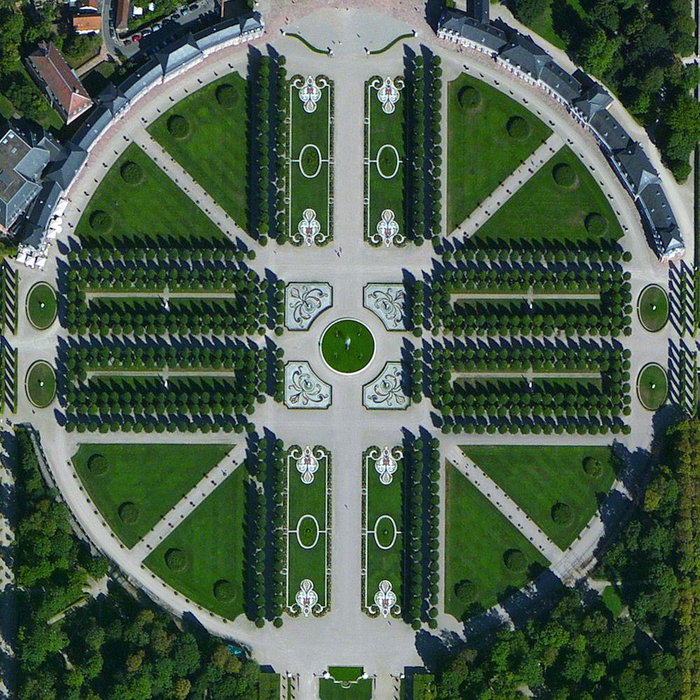
Seattle Center
47.620389°, -122.349111° - Seatlle, Washington, USASeattle Center is an arts, educational, tourism and entertainment center in Seattle, Washington. Its landmark feature is the 605-foot (184 m) tall Space Needle, an observation tower that has become a symbol of the city. Other attractions shown in this Overview include the Museum of Pop Culture (bottom left) and the Seattle Children’s Museum (bottom right).
Nearmap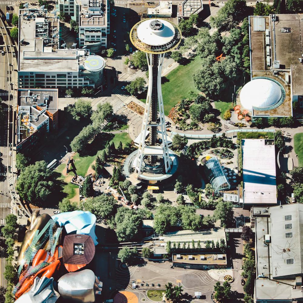
Seattle Spiders
47.621500°, -122.350861° - Seattle, Washington, USADon't worry — even though they look real, these giant spiders are just 3-D paintings on the roof of the Seattle Center Armory in Seattle, Washington. Muralist Marlin Peterson painted these two Opiliones, or "Harvestmen" arachnids in August 2012 through a grant from the Washington State Artist Trust. Situated just under the iconic Space Needle observation tower, the mural is viewed from above by nearly 1.3 million visitors per year.
Nearmap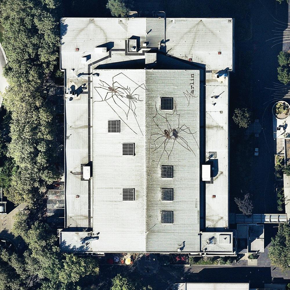
Seattle-Tacoma International Airport
47.448889°, -122.309444° - Seattle, Washington, USAI’ll be heading to Seattle, Washington, this morning for the State of the Map Conference! My flight to Seattle-Tacoma International Airport will be one of the roughly 380,000 aircraft movements that take place at the facility each year and I will be one of roughly 42 millions passengers that travel through the airport annually. The facility also contains a 13,000-car parking garage, the largest structure of its kind in North America, which is visible at the top of this Overview.
Maxar Technologies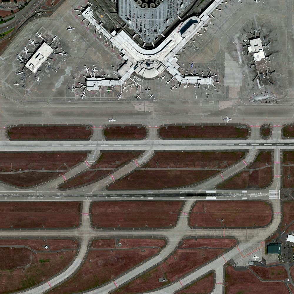
Seaweed Farms
-8.695228°, 115.441324° - Nusa Lembongan, IndonesiaSeaweed farms on Nusa Lembongan – a small island located southeast of Bali, Indonesia – have an average harvest of 50,000 pounds per month. Once the seaweed is extracted from the water, it is dried by the sun for 3-7 days, depending on the season.
Maxar Technologies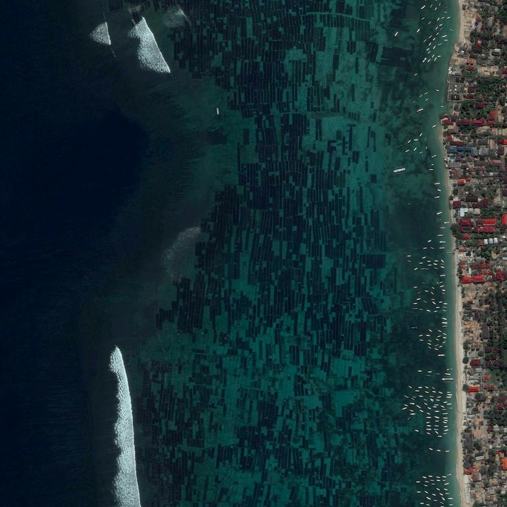
Seaweed Farms off South Korea's southern coast
34.396552°, 127.261377° - South KoreaSeaweed farms surround Sisan Island, off the south coast of South Korea. In “fields” like these, seaweed is often grown on ropes attached to buoys, which hold the crop near the water’s surface. The southern waters of South Korea are ripe with aquaculture operations like these; in fact, this region produces 90% of the nation’s seaweed crop.
Maxar Technologies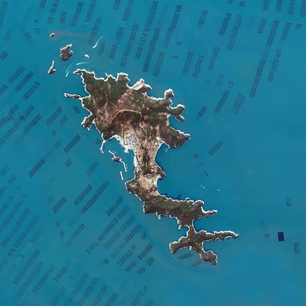
Selkirk Yard
42.554722°, -73.837222° - Selkirk, New York, USASelkirk Yard is a freight railroad yard located eight miles south of Albany, New York that serves as a gateway to points east of the Hudson River, including New York City. Using computerized controls, the yard can process more than 3,200 cars per day.
Maxar Technologies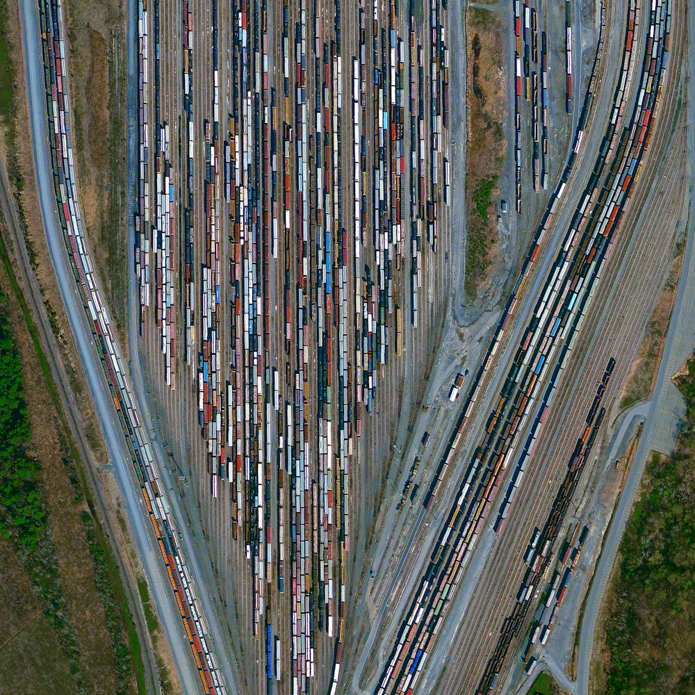
Seoul
37.512000°, 127.017900° - Seoul, South KoreaSeoul is the capital and largest city in South Korea with a population greater than 25 million. Situated on the Han River, Seoul's history stretches back over two thousand years to when it was founded in 18 BC by the people of Baekje. The Gangnam District, which literally means “South of the River”, is visible in this Overview.
Maxar Technologies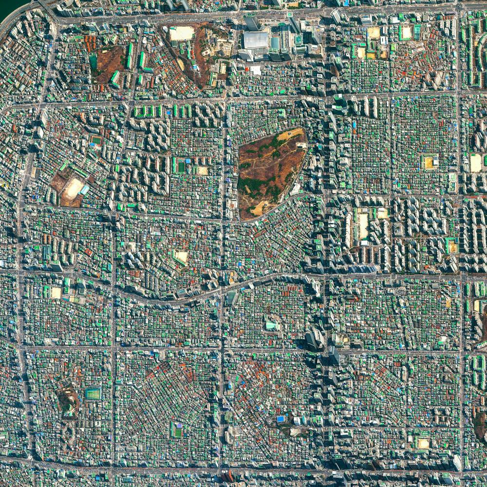
Seoul
37.566667°, 126.966667° - Seoul, South KoreaSeoul is the capital and largest metropolis of South Korea, with more than 25 million residents in its metropolitan area. Strategically situated on the Han River, Seoul’s history can be traced back more than 2,000 years to 18 BC, when it was founded by members of the Baekje Kingdom. In recent years, the city has experienced massive economic growth and is one of the top 10 wealthiest cities in the world with a GDP of more than $700 billion (USD).
Maxar Technologies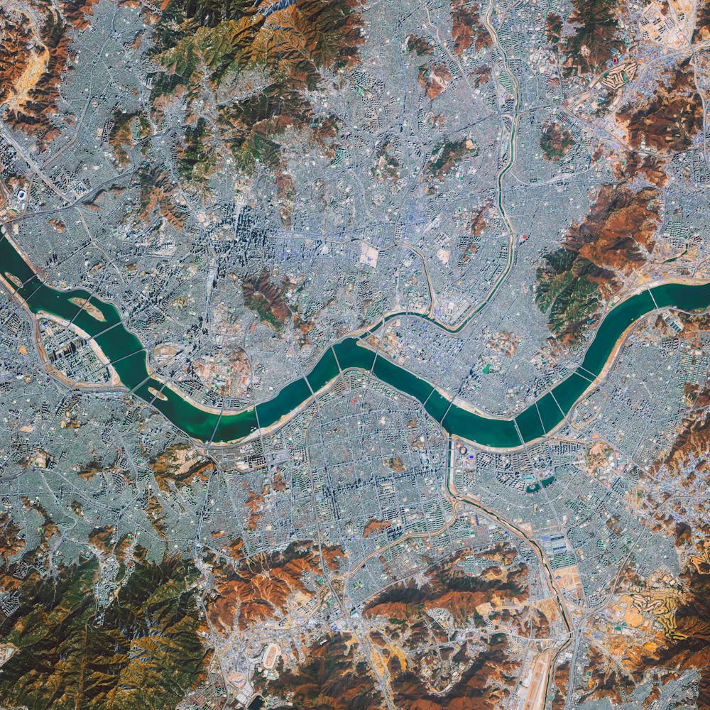
Sepang Goldcoast Resort
2.598436°, 101.683153° - Selangor Darul Ehsan, MalaysiaWe’re feeling very tropical with this Overview of the Sepang Goldcoast Resort in Selangor Darul Ehsan, Malaysia. The hotel features over-water bungalows that extend out in a palm-shaped formation into the calm waters of the Malacca Straits.
Maxar Technologies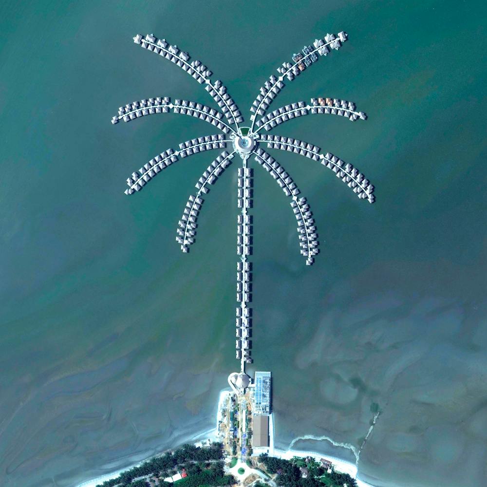
Serra de Santa Bárbara Volcano
38.729723°, -27.333654° - Terceira, Azores, PortugalSerra de Santa Bárbara is an inactive volcanic peak on the island of Terceira in the Azores, Portugal. At 3,350 feet (1,021 m), it is the highest point on the island. Just below the peak is the Santa Bárbara Caldera, which is roughly 0.6 miles (1 km) in diameter and has two smaller peaks in its center.
Maxar Technologies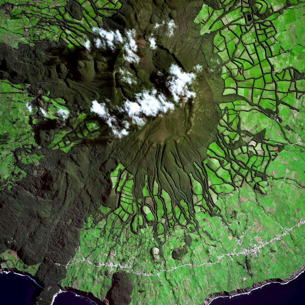
Seuss Landing
28.472889°, -81.470000° - Orlando, Florida, USASeuss Landing is one of eight “islands” inside Universal’s Islands of Adventure theme park in Orlando, Florida. It is based on the works of author Dr. Seuss and features attractions such as “The High in the Sky Seuss Trolley Train Ride” and a “Green Eggs and Ham Cafe.” True to Seussian style, the theme park claims that no straight lines exist in its design — even palm trees left bent by Hurricane Andrew were re-planted at the park to advance this theme.
Nearmap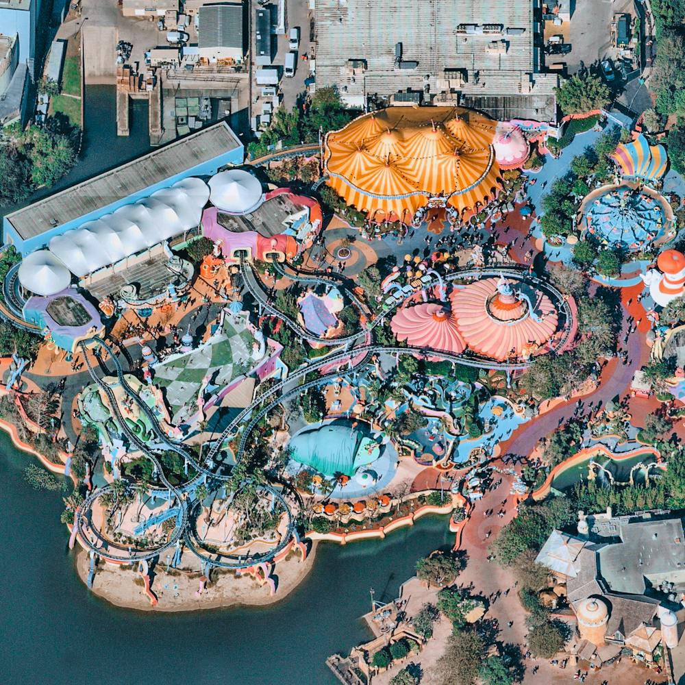
Seville Solar Concentrator
37.560556°, -5.331417° - Seville, SpainThe Gemasolar Solar Concentrator in Seville, Spain, contains 2,650 heliostat mirrors that focus the sun’s thermal energy to heat molten salt flowing through a 460-foot-tall (140m) central tower. The molten salt then circulates from the tower to a storage tank, where it is used to produce steam and generate electricity. In total, the facility displaces approximately 30,000 tonnes of carbon dioxide emissions every year.
Maxar Technologies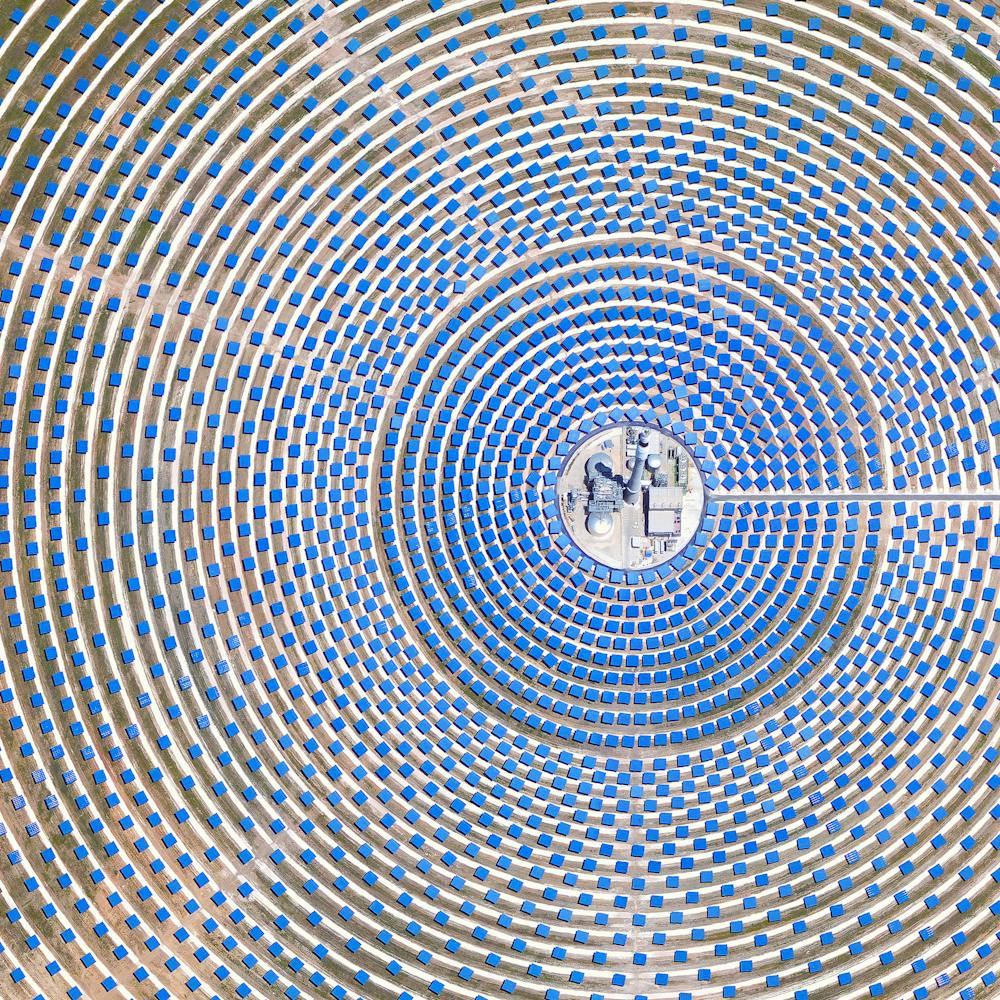
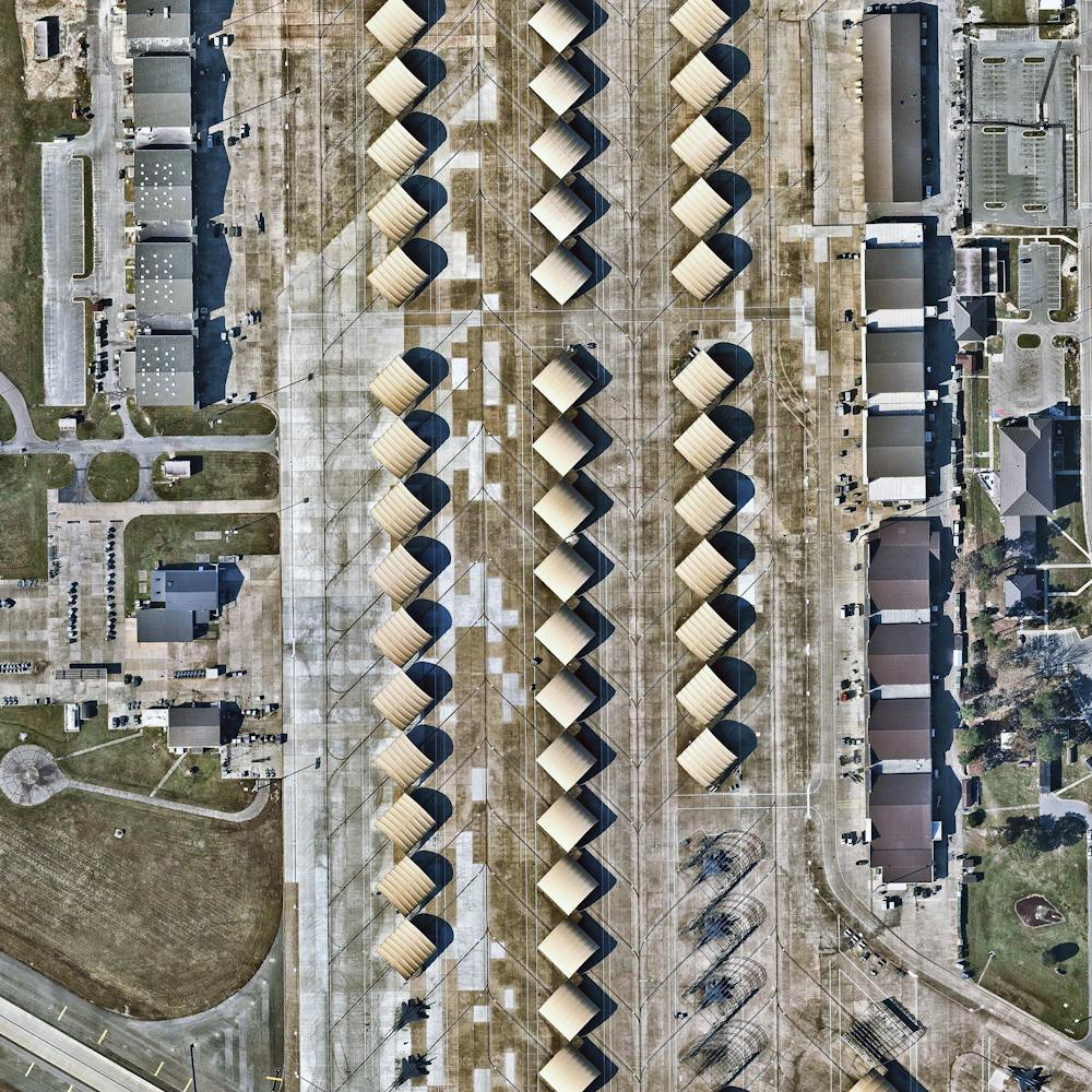
Seymour Johnson Air Force Base
35.351000°, -77.963000° - Goldsboro, North CarolinaPlanes sit under coverings on the tarmac of Seymour Johnson Air Force Base in Goldsboro, North Carolina. The base was established in June 1942 and served as a training facility throughout World War II before it was deactivated in May 1946. Since reopening as a Tactical Air Command Base in 1956, it has been home to B-52 bombers, KC-10 and KC-135 tankers, and F-4 and F-16 fighters.
Nearmap