Explore
 Shop
Shop About
About Search
Overview Index
Queens Unisphere
40.746417°, -73.844833° - New York City, New York, USAThe Unisphere is a spherical stainless steel representation of the Earth, located in Flushing Meadows-Corona Park in the New York City borough of Queens. Commissioned as part of the 1964 New York World’s Fair, the sculpture was dedicated to “man’s achievements on a shrinking globe in an expanding universe.” It is 140 feet (43 m) high and 120 feet (37 m) in diameter.
Nearmap
Rapid City Salvage Yard
44.109263°, -103.184094° - Rapid City, South Dakota, USAThousands of vehicles are stored at a salvage yard in Rapid City, South Dakota, where they will be scrapped for usable parts and recycled back into raw materials. In the U.S. alone, between 12 and 15 million vehicles reach the end of their lives every year, making them the most-recycled consumer product in the nation. Currently, about 75% of all vehicle materials can be salvaged and recycled.
Nearmap
Rapids Water Park
26.771028°, -80.106944° - Riviera Beach, Florida, USARapids Water Park is a water park in Riviera Beach, Florida, attracting roughly 400,000 visitors per year. Founded in 1979 with just four water slides, the park has expanded to offer 42 slides and other attractions including a wave pool, a lazy river, and small-scale rides for children and toddlers. Riviera Beach is the easternmost municipality in the Miami metropolitan area.
Nearmap
Rauchenwarth Fields
48.081861°, 16.529000° - Rauchenwarth, AustriaColorful fields surround Rauchenwarth, a small municipality in eastern Austria. Located roughly 10.5 miles (17 km) outside of Vienna, Rauchenwarth has a population of about 700 people. Cold, wet winters and hot, dry summers make this region ideal for growing corn, wheat, barley, rye, sugar beets, sunflowers, and soybeans.
Maxar Technologies
Raung Volcano
-8.125000°, 114.041667° - -8.125000°, 114.041667°Lava and ash billow out of Raung, one of the most active volcanoes on the island of Java in Indonesia. Raung towers more than 10,000 feet above sea level and was captured here during a powerful eruption in 2015 with a short-wave infrared satellite camera. The ash produced during this activity forced the closure of numerous airports on the island.
Maxar Technologies
Reggane Rock
25.035917°, -3.151167° - Reggane, AlgeriaCheck out this incredible rock formation we found in the Sahara Desert, near the town of Reggane, Algeria. The climate in this region is torrid and almost rainless, with an average annual rainfall of less than 0.4 inches (10 mm). In the summer, daytime temperatures are known to consistently reach 122°F (50°C), earning this area its nickname — the “triangle of fire.”
Maxar Technologies
Reggane Rock Formations
25.017389°, -3.050361° - Reggane, AlgeriaThis Overview shows colorful rock formations in the Sahara Desert, west of the town of Reggane, Algeria. The climate in this region is torrid and almost rainless, with an average annual rainfall of less than 0.4 inches (10 mm). In the summer, daytime temperatures are known to consistently reach 122°F (50°C), earning this area its nickname — the “triangle of fire.”
Maxar Technologies
Residential & Agricultural development
31.887639°, 121.646788° - Jiulongzhen, Anhui, ChinaIndividual homes and agricultural lots stretch across the landscape of Jiulongzhen in the Anhui Province of China.
Maxar Technologies
Residential development
36.135357°, -115.306898° - Las Vegas, Nevada, USAHundreds of residential homes are seen in the southwestern suburbs of Las Vegas, Nevada, USA. The city’s metro area is home to roughly two million people.
Nearmap
Residential development
26.475548°, -80.156470° - Delray Beach, Florida, USAResidential communities are seen here in Delray Beach, Florida, USA. According to the 2010 census, 20.4% of the town’s 34,156 households are vacant.
Maxar Technologies
Residential Development
31.103526°, -97.769887° - Killeen, Texas, USAResidential homes in Killeen, Texas. The town’s population grew from 86,911 to more than 127,000 in the decade between the 2000 and 2010 censuses, making it one of the fastest growing areas in the United States.
Maxar Technologies
Residential houses
39.671868°, -74.238280° - Manahawkin, New Jersey, USAResidential houses are built along canals in Manahawkin, New Jersey, USA. The town’s name is believed to have come from a Lenape word meaning "fertile land sloping into the water.”
Maxar Technologies
Rice paddies
23.158998°, 102.755424° - Yuanyang County, ChinaRice paddies, constructed in steps, cover the mountainsides of Yuanyang County, China. Cultivated by the Hani people for the last 1300 years, the slope of the terraces varies from 15 to 75 degrees with some having as many as 3,000 steps.
Maxar Technologies
Richat Structure
21.124000°, -11.402000° - Sahara Desert, MauritaniaThe Richat Structure, also known as the “Eye of the Sahara,” is a prominent circular feature in the Sahara Desert of west-central Mauritania. Measuring 30 miles (50 km) in diameter, the structure was originally thought to have been formed by the impact of an asteroid; however, it is now known to be an eroded structural dome of layered sedimentary rocks.
Axelspace
Rimini Beach Umbrellas
44.064972°, 12.586833° - Rimini, ItalyBeach chairs and parasols dot the shoreline of Rimini Beach, in northern Italy. Located on the Adriatic Sea, Rimini is a city of roughly 150,000 people and is one of the most famous seaside resorts in Europe. Its 9-mile-long (14.5km) sandy beach is surrounded by more than 1,000 hotels and thousands of bars, clubs and restaurants.
Maxar Technologies
Rio Tinto River
37.730778°, -6.600667° - Huelva, SpainSince ancient times, the Rio Tinto Mines in Huelva Province, Spain, have been excavated for copper, silver, gold, and other minerals. They are named for the nearby Rio Tinto River, which — as a result of centuries of mining — is extremely acidic and has a distinct red-orange color. After being closed for more than a decade, the mines reopened in 2015 an remain operational today.
Maxar Technologies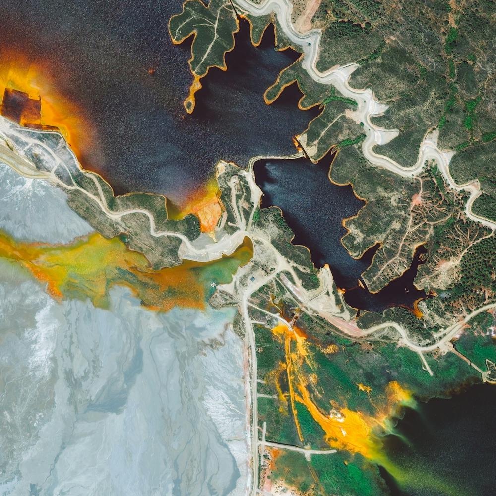
Riyadh - Low Angle
24.633333°, 46.716667° - Riyadh, Saudi ArabiaCheck out this amazing view of Riyadh, Saudi Arabia, captured by a Planet satellite at a low angle. Riyadh is Saudi Arabia’s capital and most populous city, with more than 7.6 million residents. At the center of this Overview is the King Abdullah Financial District, a $10 billion development project that began in 2006 and is now more than 70% complete.
Planet
Rodewald
52.665833°, 9.482222° - Rodewald, GermanyFields surround the residential area of Rodewald, Germany. The agricultural village was first mentioned in historical records from the early 13th Century and is now home to 2,549 people.
Maxar Technologies
Roebuck Bay
-18.085832°, 122.265540° - Roebuck Bay, Western AustraliaRoebuck Bay is a 210-square-mile (550 sq. km) tropical marine embayment in the Kimberley Region of Western Australia. Much of the Bay’s eastern edge contains tidal creeks, which create vein-like patterns on its red sandy beaches. Mangrove swamps connected to these tidal creeks serve as important nursery areas for marine fish and crustaceans.
Maxar Technologies
Roebuck Bay
-17.969389°, 122.237861° - Broome, Western AustraliaThe aquamarine water of Roebuck Bay rolls onto red sand in Broome, Western Australia. A coastal town, Broome is home to roughly 14,000 people, but its population can grow to upwards of 45,000 per month during peak tourist season from June to August.
Nearmap
Roseville Yard
38.728268°, -121.312351° - Roseville, California, USARoseville Yard, located north of Sacramento, California is the largest rail facility on the west coast of the United States. Operated by the Union Pacific Railroad, the yard accommodates approximately 98 percent of all rail traffic in the north of the state.
Maxar Technologies
Rotonda West
26.887778°, -82.271389° - Rotonda West, FloridaRotonda West is an unincorporated community in Florida, USA that is shaped like an incomplete wagon wheel. A freshwater canal system surrounds the outside of the wheel and travels inside each of the pie-shaped wedges to form the subdivisions of the development. The wheel was not fully completed because the undeveloped area is a wetland is a habitat for a number of animals such as alligators, bald eagles, and great blue herons.
Maxar Technologies
Rottnest Island Yacht
-31.994995°, 115.560582° - Perth, AustraliaA yacht cruises around Rottnest Island, located off the coast of Perth, Western Australia. The dark blotches seen in the water are parts of the Kingston Reef — one of five Marine Sanctuary Zones surrounding the island. These zones form a habitat for many species of fish and crustaceans, bottlenose dolphins, blue whales, Australian sea lions, New Zealand fur seals, and migrating humpbacks.
Nearmap
Rovinj
45.083333°, 13.633333° - Rovinj, CroatiaRovinj, officially known as Rovinj-Rovigno, is a city in Croatia with roughly 15,000 residents. Located on the Istrian Peninsula in the north Adriatic Sea, it is a popular tourist destination and an active fishing port. Most people in Rovinj are bilingual, speaking Croatian and Italian — and a handful even speak Istriot, an endangered Romance language with less than 1,000 speakers left.
Maxar Technologies
Sagrada Familia at Dusk
41.403561°, 2.174347° - 41.403561°, 2.174347°This drone shot captures the Sagrada Família neighborhood of Barcelona, Spain, at dusk. Pictured at the top of the frame is the neighborhood’s namesake, the Basílica de la Sagrada Família, a large unfinished Roman Catholic basilica designed by famed architect Antoni Gaudí. The structure is the most-visited tourist attraction in the city, bringing in more than 3 million visitors per year.
The Drone Lad
Sahara Desert Sand Dunes
23.100944°, -7.117417° - MauritaniaSand dunes zigzag across the Sahara Desert in the Tiris Zemmour Region of Mauritania. Since the majority of Mauritania is covered by desert, temporary dune ranges like those in this Overview can form, disappear and reform as sands shift. Average rainfall in Tiris Zemmour is around 3.9 inches (100mm) per year.
Maxar Technologies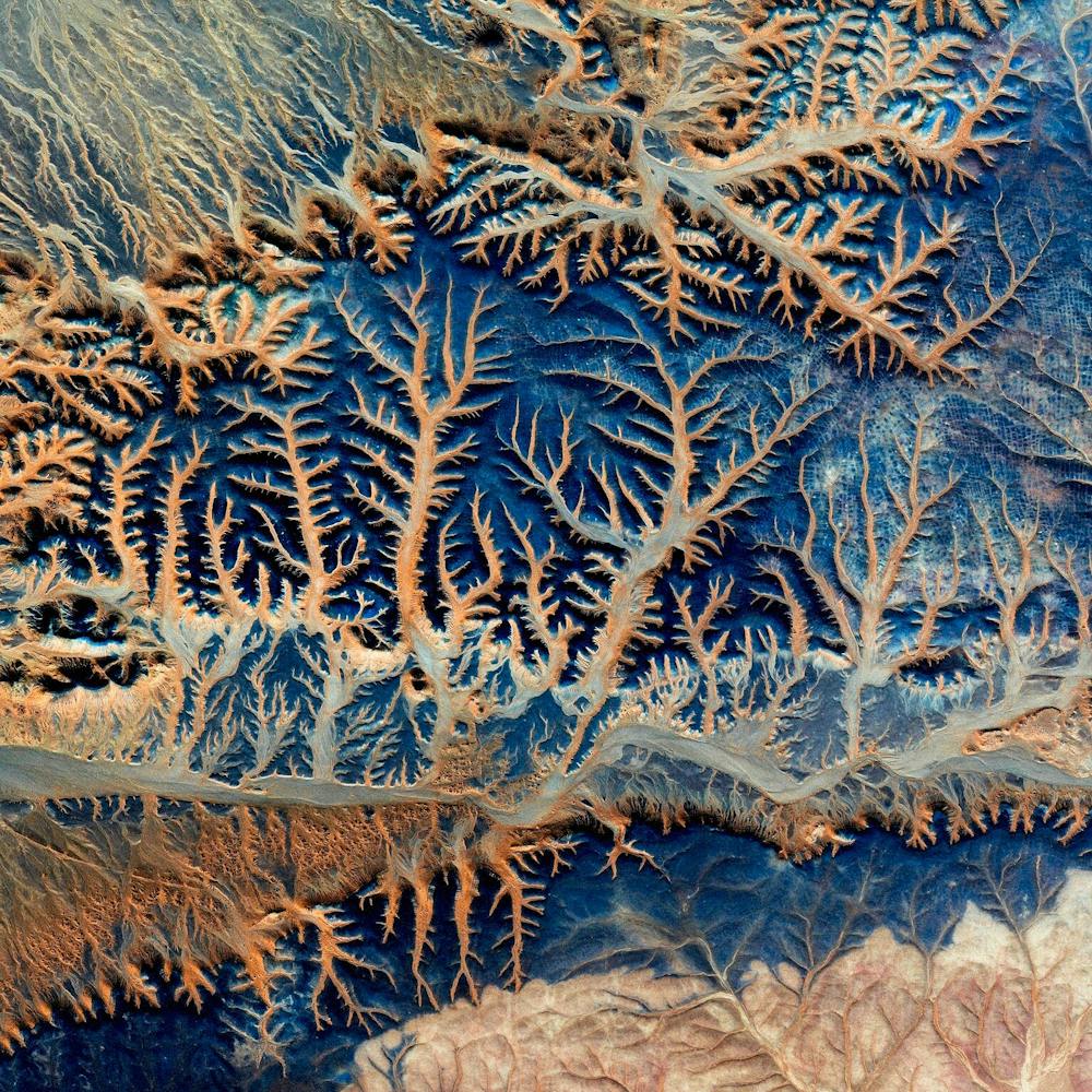
Sakai Tumuli
34.562556°, 135.486417° - Sakai, JapanKeyhole-shaped tumuli are scattered throughout the city of Sakai in Japan's Osaka Prefecture. A tumulus is a mound of earth or stone raised over a grave, and the largest one shown in this Overview is the final resting place of Emperor Nintoku. Nearly 1,600 feet (486 m) long with a mound 115 feet (35 m) high, it covers the largest area of any tomb in the world.
Maxar Technologies
Sakurajima
31.583333°, 130.650000° - Kyushu, JapanSakurajima is an active stratovolcano and a former island in Kyushu, Japan. Lava flows from the volcano’s 1914 eruption connected it with the Osumi Peninsula, as shown in the bottom left of this Overview. Since 1955, Sakurajima has been erupting almost constantly, producing thousands of small explosions every year.
Maxar Technologies
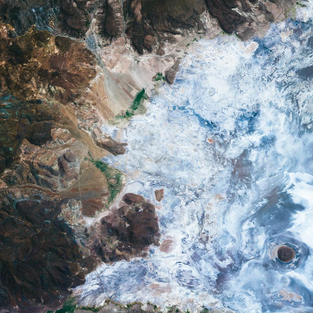
Salar de Atacama
-23.500000°, -68.250000° - ChileSalar de Atacama is the largest salt flat in Chile and the third largest in the world, spanning 1,200 square miles (3,000 sq. km). It is the world’s largest and purest active source of lithium, containing more than one-quarter of the world’s lithium reserves. In this Overview, lithium-rich waters sit in a series of evaporation ponds before being extracted as lithium carbonate — a key ingredient in specific industrial salts and chemicals, and in the production of lithium metal.
Maxar Technologies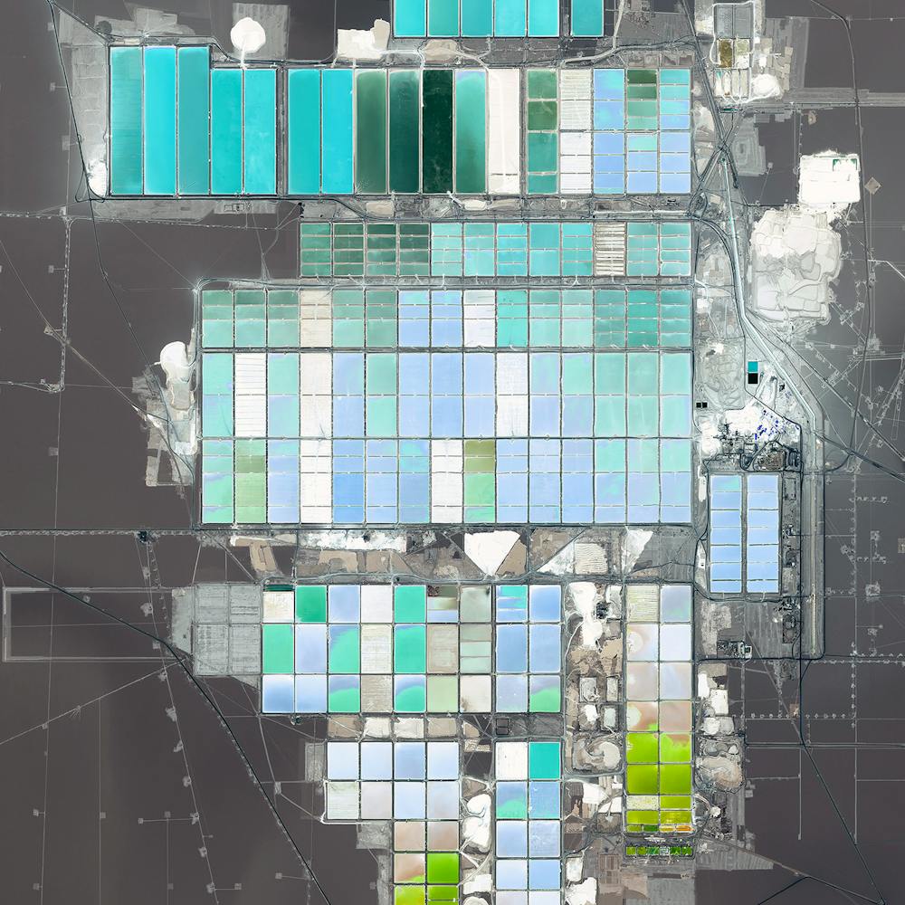
Salar de Uyuni
-20.133778°, -67.489139° - BoliviaSalar de Uyuni is the world’s largest salt flat, covering 4,086 square miles (10,582 sq. km) in southwestern Bolivia. This area is estimated to contain roughly 10 billion tons of salt, underneath which lies between 50% and 70% of the world’s known lithium reserves. The salar also contains large amounts of sodium, potassium, magnesium and borax.
Maxar Technologies