Explore
 Shop
Shop About
About Search
Overview Index
Port Hedland
-20.330472°, 118.569278° - Pilbara, Western AustraliaPort Hedland is the largest iron ore loading port in Australia and one of the largest in the world. Located in the Pilbara Region of Western Australia, the port recorded a throughput of more than 550 million tons between 2016 and 2017. In March 2017, Port Hedland had its record single shipment of 297,000 tons, which was aboard the HL Tubarao, an 1,115-foot-long (340 m) vessel from Panama.
Maxar Technologies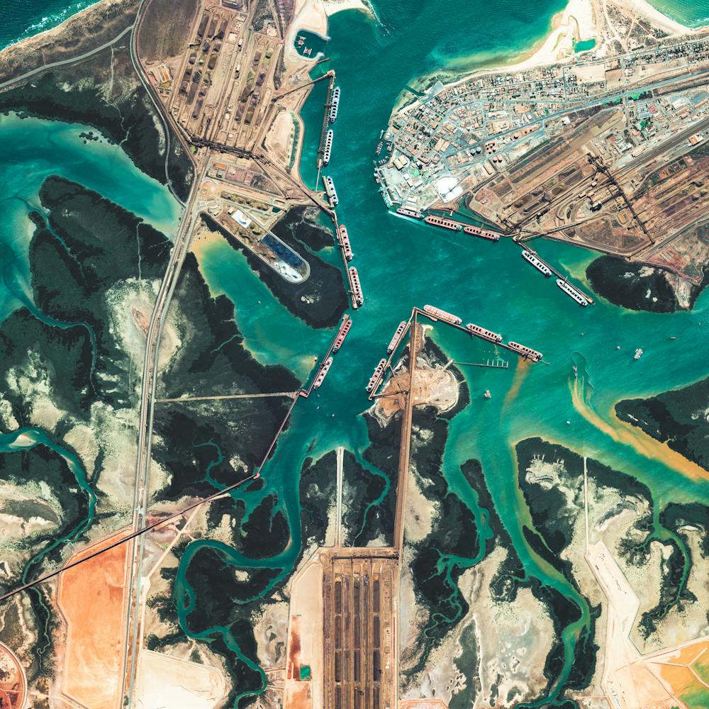
Port Hercules
43.735056°, 7.425139° - MonacoPort Hercules, the only deep-water port in Monaco, provides anchorage for up to 700 vessels. Monaco has an area of 0.78 square miles and a population of 36,371, making it the second smallest and the most densely populated country in the world.
Maxar Technologies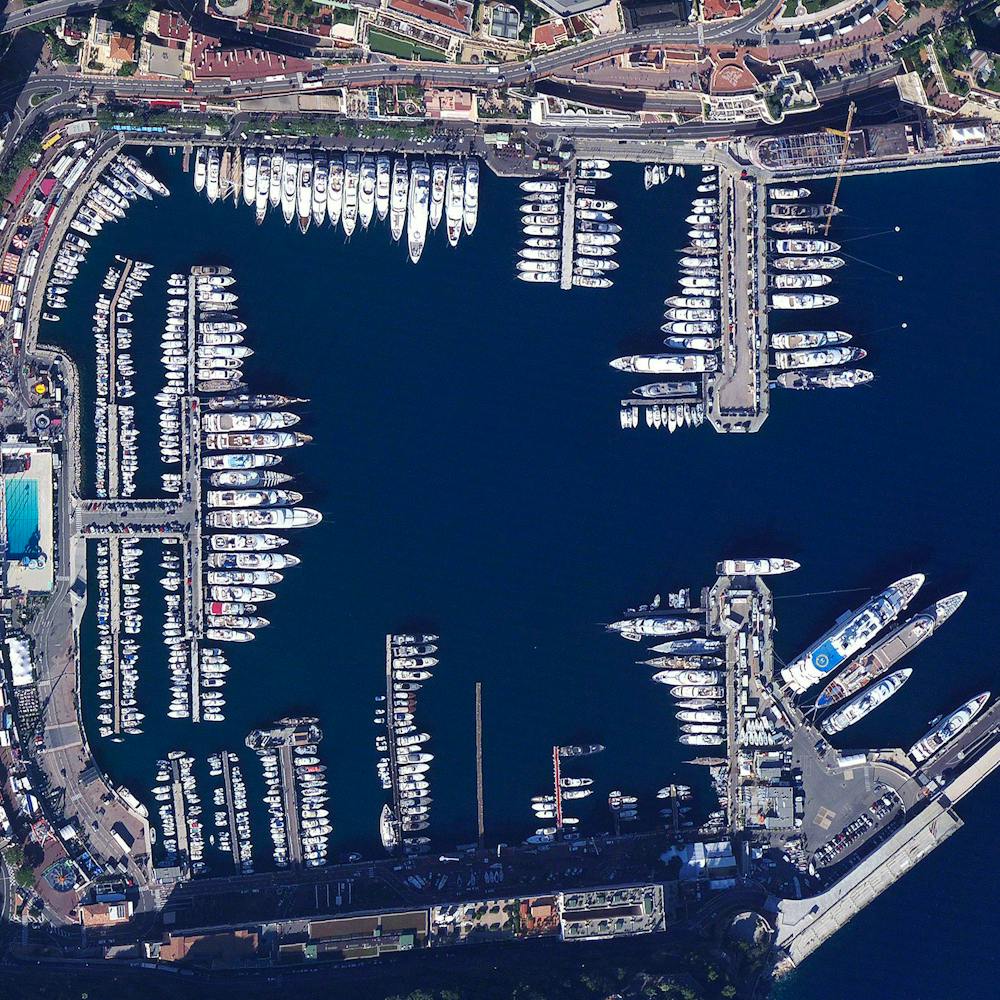
Port Newark
40.681667°, -74.150556° - Newark, New JerseyShipping containers are stacked at the Port Newark Container Terminal in Newark, New Jersey, USA. The massive facility handles over 600,000 shipping containers every year and has begun expansion projects that will increase annual capacity to 1.1 million containers by 2030.
Nearmap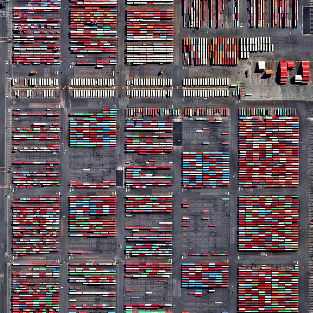
Port of Antwerp
51.270000°, 4.336667° - Flanders, BelgiumThe Port of Antwerp in Flanders, Belgium, is the second-largest seaport in Europe. Its inland location on a tidal estuary of the Scheldt River gives it an advantage over other North Sea ports, allowing its docks to connect to rail, road, river and canal transit systems. In 2018, nearly 14,600 seagoing vessels called at the Port of Antwerp with a combined transshipment of 235.2 million tonnes.
Maxar Technologies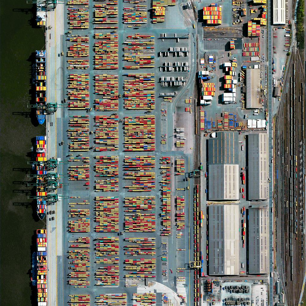
Port of Copenhagen
55.671800°, 12.581700° - Copenhagen, DenmarkThe Port of Copenhagen in Copenhagen, Denmark has one of the largest passenger terminals in the Baltic Sea, handling more than 1.6 million passengers annually. A cruise ship with an approximate length of 1000 feet (305 meters) is seen at one of its docks. The facility also contains one of the region’s busiest cargo terminals, which moves more than 18 million tonnes of cargo each year.
Maxar Technologies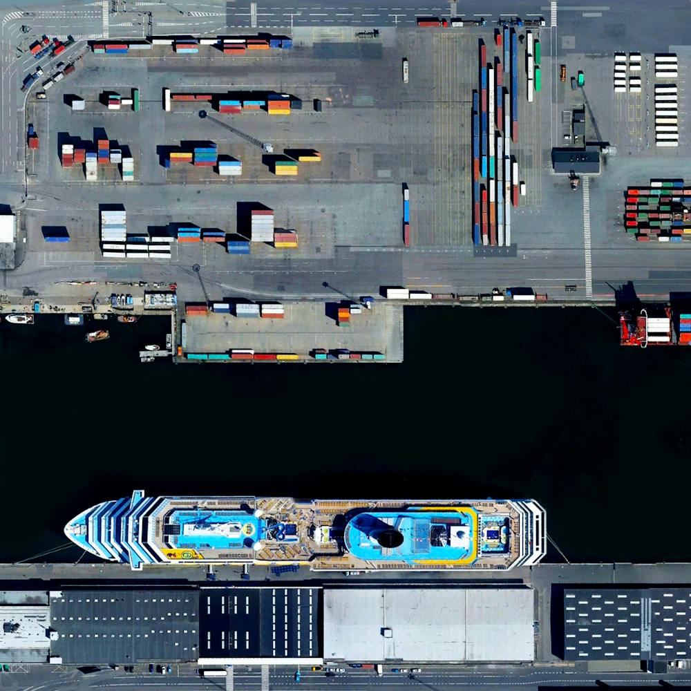
Port of Felixstowe
51.954171°, 1.310158° - Felixstowe, UKThe Port of Felixstowe is the busiest port in the United Kingdom, handling approximately 42% of the country’s trade of shipping containers. The facility is able to accommodate ships that extend more than 400 meters (1312 feet) and have a cargo carrying capacity that is greater than half the volume of the Empire State Building.
Maxar Technologies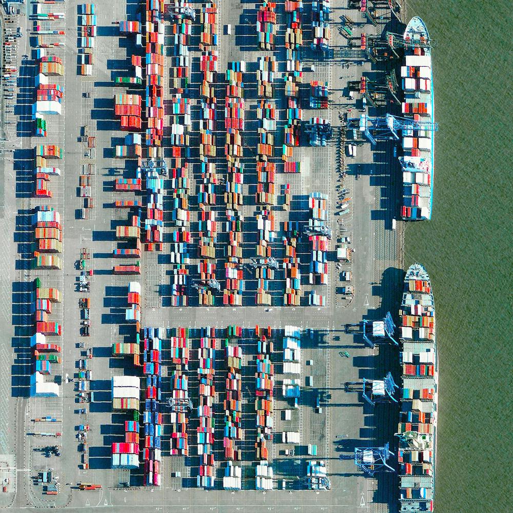
Port of Hamburg
53.532581°, 9.916544° - Hamburg, GermanyThe Port of Hamburg - known as Germany’s “Gateway to the World” - is located on the Elbe River in Hamburg. On an average day, the facility is accessed by 28 ships, 200 freight trains, and 5,000 trucks. In total, the port moves 132.3 million tonnes of cargo each year - that’s roughly 1/3 of the mass of all living human beings.
Maxar Technologies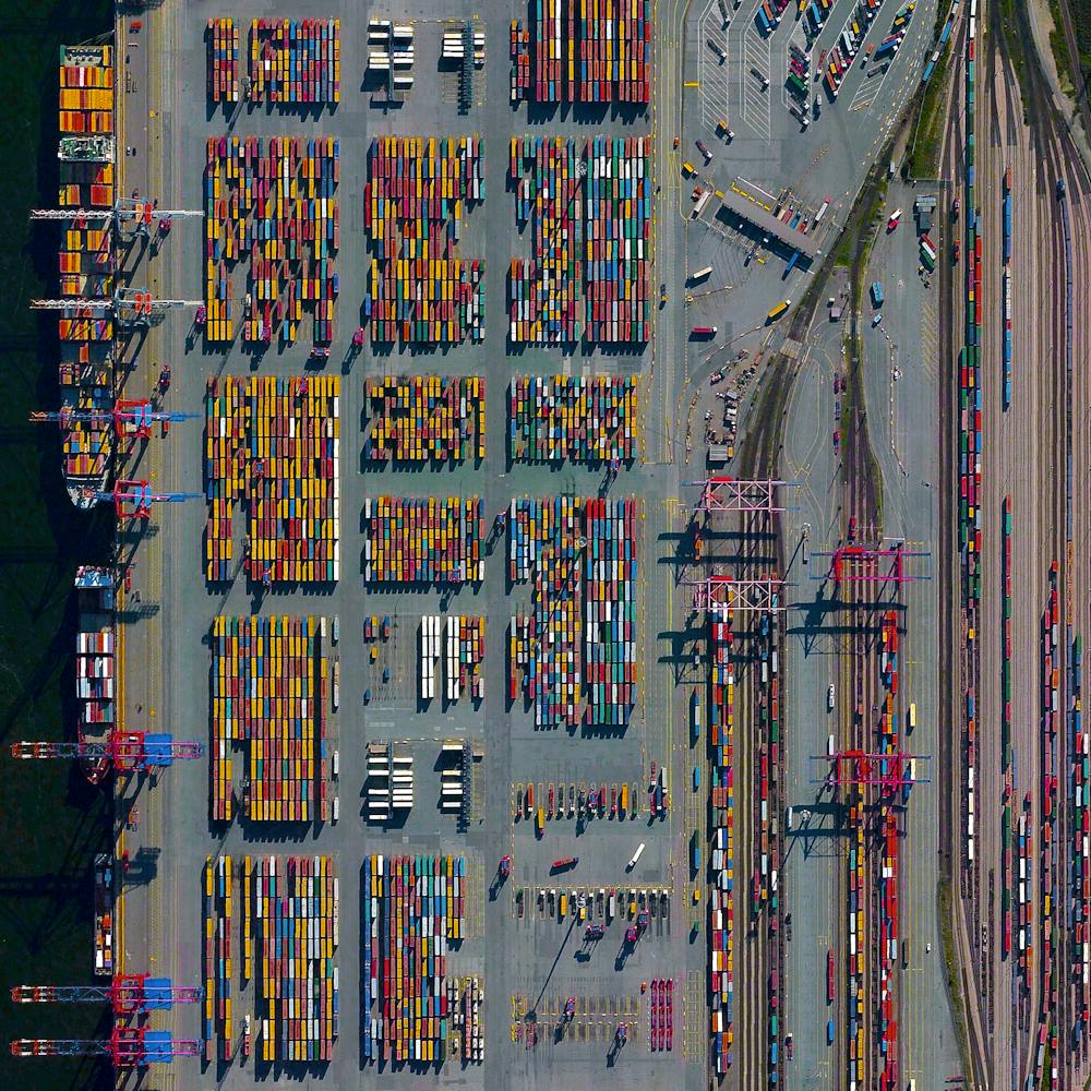
Port of Long Beach
33.754185°, -118.216458° - Long Beach, CaliforniaShipping containers are loaded into a massive cargo ship (1200+ feet) at the Port of Long Beach — the second-busiest container port in the United States. The seaport generates approximately $100 billion in trade, employs more than 316,000 people, and along with the Port of Los Angeles to which it is connected, serves as the single largest source of air pollution in the metropolitan LA area.
Nearmap
Port of Los Angeles
33.729167°, -118.261944° - Los Angeles, California, USAThe Port of Los Angeles is the busiest container port in the United States, but only the 16th-busiest in the world. Approximately $1.2 billion worth of cargo comes through the facility each day and more than 165 million metric revenue tons of cargo are moved here each year. The most-imported types of goods are furniture, automobile parts, apparel, electronic products, and footwear.
Maxar Technologies
Port of Los Angeles Trucks
33.728611°, -118.240333° - Los Angeles, California, USALong-haul trucks wait in line to exit the Port of Los Angeles in California. It is estimated that there are approximately 3.5 million truck drivers in the United States and they drive nearly 140 billion miles on American highways every year. In total, 433 billion miles are covered annually by the entire population.
Nearmap
Port of Rotterdam
51.950990°, 4.065449° - Rotterdam, NetherlandsTwo container ships are docked at the Port of Rotterdam in the Netherlands. From 1962 until 2002 it was the world’s busiest port, but was overtaken first by the the port in Singapore and later by the facility in Shanghai, China. Container ships such as these can weigh up to 300,000 tons and extend up to 1,200 feet (366 meters).
Maxar Technologies
Port of Rotterdam
51.952790°, 4.053669° - Rotterdam, NetherlandsShipping containers are seen at the Port of Rotterdam in the Netherlands. From 1962 until 2002, the facility was the world’s busiest port, but was overtaken first Singapore and later Shanghai. In 2015, Rotterdam ranked as the world’s sixth-largest port in terms of annual cargo tonnage.
Maxar Technologies
Port of Rotterdam Dry Terminal
51.938843°, 4.047934° - Rotterdam, NetherlandsThe dry terminal at the Port of Rotterdam in the Netherlands is the busiest transshipment facility of its kind in Europe - moving primarily coal and iron ore. The massive vessels that dock here carry up to 380,000 tonnes of these minerals to power plants and blast-furnaces in Germany, France, Belgium, and other European countries.
Maxar Technologies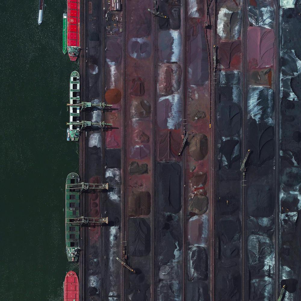
Port of Savannah
32.128705°, -81.151907° - 32.128705°, -81.151907°The Port of Savannah is a major U.S. seaport located in the city of Savannah, Georgia. Its facilities for oceangoing vessels line both sides of the Savannah River, approximately 18 miles (29 km) from the Atlantic Ocean. Between July 2018 and 2019, a record 4.5 million twenty-foot equivalent container units were moved at the Port of Savannah.
Nearmap
Port of Shanghai
30.626393°, 122.062528° - Shanghai, ChinaThe Port of Shanghai is the world’s busiest container port, handling more than 35 million TEUs (approximately 776 million tons) of cargo every year. That weight is roughly equal to 1.7 times the mass of all humans living on the planet.
Maxar Technologies
Port of Tacoma
47.262278°, -122.389556° - Tacoma, Washington, USAA freighter full of shipping containers docks in the Port of Tacoma, located in Washington State. Together, the Ports of Tacoma and Seattle make up the fourth-largest container gateway in North America. In 2016, cargo traffic through the ports totaled 3.6 million twenty-foot equivalent units (TEUs) weighing 28 million metric tons.
Nearmap
Port of Tacoma Roofing Storage
47.259306°, -122.405611° - Tacoma, Washington, USAWooden pallets of roofing material are stacked next to the Port of Tacoma, Washington. In 2015, the Port of Tacoma handled $52.1 billion in international trade, importing and exporting 19 million short tons of cargo.
Nearmap
Port of Tanjung Priok
-6.104000°, 106.886500° - Jakarta, IndonesiaDozens of massive cargo ships and tankers - some weighing up to 300,000 tons - are anchored outside the Port of Tanjung Priok in Jakarta, Indonesia. The facility is the country's busiest and most advanced seaport, handling more than 50% of Indonesia's trans-shipment cargo. The port is also among the least efficient in all of Southeast Asia, due to slow customs handling and limited docking capacity.
Maxar Technologies
Port of Vancouver
49.017889°, -123.159583° - Vancouver, CanadaThe Roberts Bank Superport is a shipping facility in the Port of Vancouver, just offshore the city of Delta in British Columbia, Canada. It is home to the single busiest coal export terminal in North America, which typically ships more than 20 million tons of export coal a year. Currently, there are plans to expand the facility and add a new three-berth container terminal, which would provide an additional 2.4 million twenty-foot equivalent units of container capacity.
Nearmap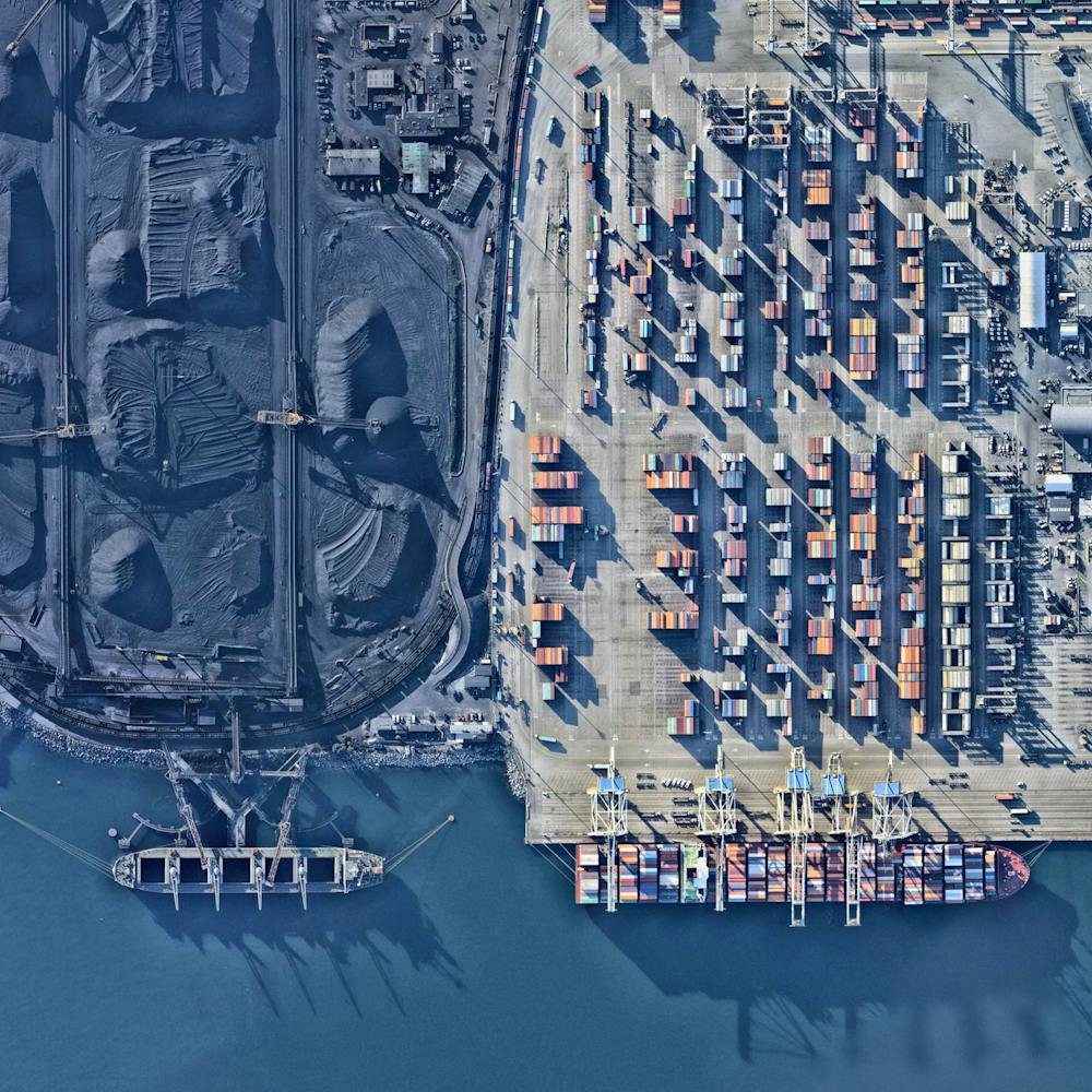
Port Vauban
43.586556°, 7.125861° - Antibes, FranceMassive yachts are docked in the stunning blue water of Port Vauban, a harbor located in Antibes on the French Riviera. The facility is the largest marina on the Mediterranean Sea in terms of total tonnage of the boats that are moored here.
Maxar Technologies
Potash evaporation ponds
38.483378°, -109.681333° - Moab, Utah, USABlue evaporation ponds are visible at the Intrepid Potash Mine in Moab, Utah, USA. The mine produces muriate of potash, a potassium-containing salt used widely by farmers in fertilizer. The salt is pumped to the surface from underground brines and dried in massive solar ponds that vibrantly extend across the landscape. As the water evaporates over the course of 300 days, the salts crystallize out. So why are you seeing such vibrant colors? The water is dyed bright blue to reduce the amount of time it takes for the potash to crystallize; darker water absorbs more sunlight and heat.
Maxar Technologies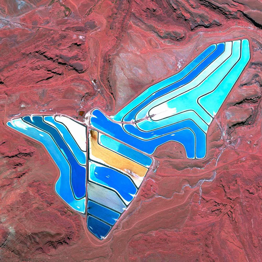
Powderhorn Park
44.942944°, -93.256916° - Minneapolis, Minnesota, USAPowderhorn Park is a residential neighborhood of Minneapolis, Minnesota, consisting mostly of single-family homes, duplexes and some low-rise apartment buildings. The community's eponymous park system and lake — shown at the center of this Overview — hosts local sporting events, community education classes, and ice skating in the winter.
Nearmap
Prati
41.911165°, 12.460427° - Prati, Rome, ItalyPrati is a neighborhood located in the center of Rome, Italy. The area borders the Vatican and contains the Via Cola di Rienzo, one of the most famous shopping streets in the entire city.
Maxar Technologies
Prince Frederick Harbour Drainage
-15.000538°, 125.289947° - Prince Frederick Harbour, Western AustraliaCheck out the dendritic drainage patterns on this small bay in Prince Frederick Harbour, Western Australia. Dendritic literally means branched, as in resembling the pattern of a tree. This shape develops when streams move across relatively flat and uniform rock or over a surface that resists erosion.
Maxar Technologies
Princess Juliana International Airport
18.040823°, -63.109948° - Saint MartinPrincess Juliana International Airport is the main airport on the Caribbean island of Saint Martin. The airport is well-known for the approach to Runway 10, seen at the bottom of this Overview. Here arriving aircraft must have a 3° glide slope, flying at a shockingly low altitude over people relaxing on Maho Beach, to land safely.
Maxar Technologies
Puerto Caballas Shoreline
-14.918611°, -75.503056° - Puerto Caballas, PeruWaves roll into shore at Puerto Caballas, Peru. This area is part of the San Fernando National Reserve, a 380-acre protected area along the Pacific Ocean that is home to more than 250 species of birds, 90 different kinds of fish and crustaceans, and many reptiles and mammals. To reach this natural wonder, tourists must use off-road vehicles to traverse massive desert sand dunes.
Maxar Technologies
Puerto Vallarta
20.640861°, -105.296744° - Puerto Vallarta, MexicoPuerto Vallarta is a Mexican beach resort city situated on the Pacific Ocean. Because of the city’s popularity as a travel destination, more than half of its 221,000 residents work in a tourism-related industry. A tropical climate means the average temperature here is 78 degrees fahrenheit (26 celsius) over the course of a year.
Maxar Technologies
Qantas Jet Over Adelaide
-34.936082°, 138.602692° - Adelaide, AustraliaA Qantas jet flies over Wakefield Street in Adelaide, South Australia, after taking off from Adelaide Airport. Adelaide is the fifth-largest city in Australia, and its airport is the country’s fifth-busiest. Between 2016 and 2017, it served roughly 8 million passengers and saw an 11% increase in international travelers.
Nearmap
Qinghai Lake
37.000945°, 99.892228° - ChinaThe shores of Qinghai Lake in China are captured in this Overview. The lake is the largest in the country, covering 1,667 square miles (4317 square km), which is nearly one and a half times the size of the state of Rhode Island.
Maxar Technologies
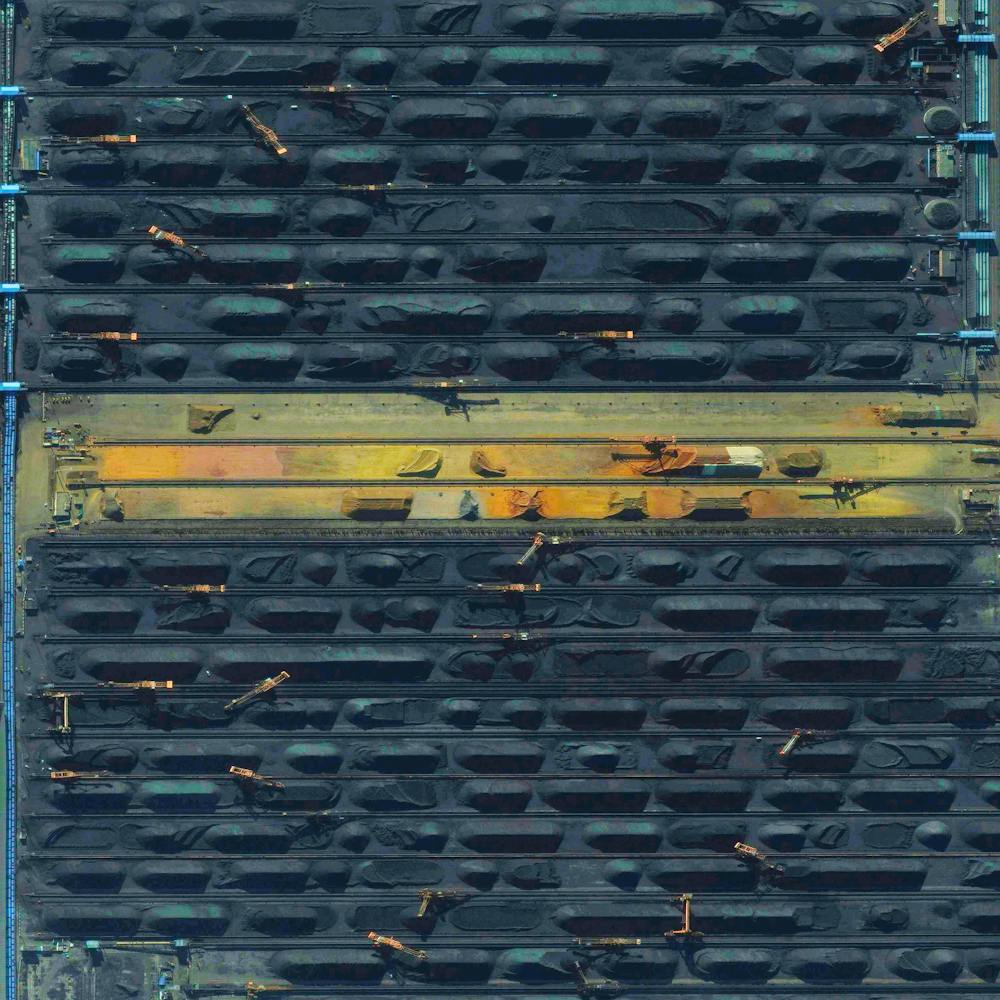
Qinhuangdao Coal Terminal
39.933622°, 119.683840° - Qinhuangdao, ChinaThis Overview shows the coal terminal at the Port of Qinhuangdao - the largest coal shipping facility in China. From here, approximately 210 million metric tons of coal are primarily transported to coal-burning power plants in the major cities in southern China each year. This figure is believed to account for approximately half of the country’s annual consumption.
Maxar Technologies