 Explore
 Shop
Shop About
About Search
Overview Index
New Bullards Bar Reservoir Houseboats
39.429030°, -121.130100° - Yuba County, California, USAThis Overview captures houseboats floating peacefully on the New Bullards Bar Reservoir in Yuba County, California. The exposed shoreline across the bottom of the image appears when the reservoir water level is low. Want to display this image in your home? Head over to our to find it and other Overviews for sale!
Maxar Technologies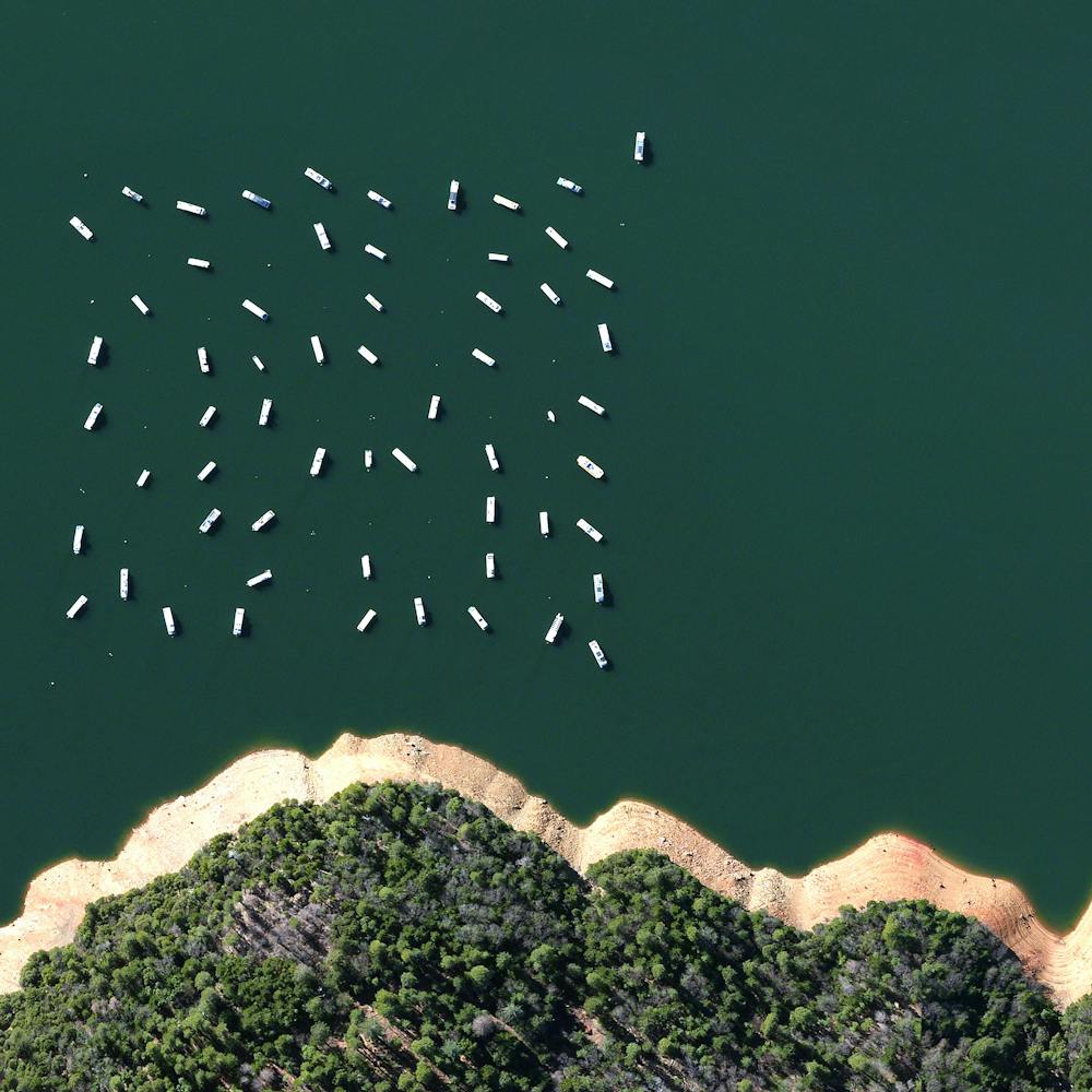
New Century Global Center
30.572222°, 104.060833° - Chengdu, ChinaThis morning I’ll fly to Chengdu, China. The city is home to the recently constructed New Century Global Center - a multipurpose facility that contains numerous shopping malls, an IMAX cinema, a “mediterranean village," a pirate ship, a skating rink, and a 500x130 foot screen that displays artificial sunrises and sunsets. The structure contains the largest amount of floor space for a single building with approximately 18 million square feet.
Maxar Technologies
New Delhi
28.615593°, 77.209023° - Delhi, IndiaNew Delhi serves as the capital of India and is home to more than 21 million residents in its metro area. Officially inaugurated in February 1931, the city was planned by British architects Sir Edwin Lutyens and Sir Herbert Baker. Their design centered around two promenades - the Rajpath and the Janpath - that run perpendicular to each other and intersect here at center.
Maxar Technologies
New Hampshire Fall Foliage
43.127639°, -71.543472° - Bow, New Hampshire, USAA colorful blanket of treetops is visible in Bow, New Hampshire. With the arrival of colder temperatures each year, leaves begin to change their colors, creating marvelous views like this from above.
Nearmap
New York City
40.661000°, -73.944000° - 40.661000°, -73.944000°New York City captured by the Worldview-3 satellite off the coast of the Atlantic ocean. We'll be in NYC next week promoting our new children's book. Come check out one of our events! DM for any additional details or tickets. Monday - The Assemblage (@theassemblagenyc) - 114 E 25th St @ 7:00 PM /// Tuesday - The Explorer's Club (@the_explorers_club) - 46 East 70th Street @ 7:00 PM /// Wednesday - Arcadia Earth (@arcadiaearth) 718 Broadway @ 7:00 PM
Maxar Technologies
New York City Low-Angle
40.717000°, -74.003000° - New York, New York, USACheck out this remarkable view of downtown New York City captured by the DigitalGlobe Worldview-3 satellite at an extremely low-angle. We’re pumped to announce that we just added this shot to our Printshop along with four others. You can check out what we added here:
Maxar Technologies
Nezahualcóyotl
19.407444°, -99.027833° - Nezahualcóyotl, Mexico City, MexicoThis Overview captures the tightly gridded streets of Nezahualcóyotl, a municipality of Mexico City. With a population of more than one million, this area is home to many of the capital’s citizens who have migrated there from other parts of the country. The Greater Mexico City area has roughly 21 million residents, making it the largest metropolitan area in North America.
Maxar Technologies
Niagara Falls
43.077107°, -79.075506° - Ontario, Canada, / New York, USANiagara Falls is the collective name for three waterfalls that straddle the border between Ontario, Canada and the United States. Horseshoe Falls is seen here. The falls have the highest flow rate of any waterfall in the world, with a vertical drop of more than 165 feet (50 m). The Maid of the Mist, also visible here, is a boat that has carried passengers into the rapids below the falls since 1846.
Nearmap
Niagara Falls - Low Angle
43.077305°, -79.075620° - Ontario, Canada, / New York, USANiagara Falls is the collective name for three waterfalls that straddle the border between Ontario, Canada, and the US state of New York. Horseshoe Falls, the largest of the three, is seen here. The falls have the highest flow rate of any waterfall in the world, with a vertical drop of more than 165 feet (50 meters).
Nearmap
Nice
43.703389°, 7.266306° - Nice, FranceNice is the fifth most populated city in France, with roughly one million inhabitants in its metropolitan area. Located in southeastern France on the Mediterranean Sea, Nice is part of the tourist-popular French Riviera. It has one of the highest hotel capacities in France and is visited by more than four million tourists each year.
Maxar Technologies
Nile River
29.336389°, 31.224667° - EgyptThe Nile River is commonly regarded as the longest river in the world, flowing for 4,258 miles (6,853 km) over 11 countries in northeastern Africa. In this Overview, it is shown flowing north through Egypt, forming a large triangular delta before emptying into the Mediterranean Sea. Civilizations since ancient times have depended on the waters of the Nile to flood and fertilize surrounding desert lands.
NASA
Nishinoshima
27.246944°, 140.874444° - JapanNishinoshima is a volcanic island located 940 kilometers south of Tokyo, Japan. Starting in November 2013, the volcano began to erupt and continued to do so until August 2015. Over the course of the eruption, the area of the island grew in size from .056 square kilometers to 2.3 square kilometers. This Juxtapose shows the island one year before the eruption began and the same location after seven months of activity.
Maxar Technologies
Nisqually River
47.082500°, -122.721667° - Washington, USAThe Nisqually River flows for roughly 81 miles (130 km) through west central Washington, emptying into the southern end of the Puget Sound. The river’s delta, captured in this Overview, is both a National Wildlife Refuge and a National Natural Landmark, providing a habitat for more than 300 different species of fish and wildlife.
Maxar Technologies
Normandy American Cemetery and Memorial
49.360278°, -0.857222° - Colleville-sur-Mer, FranceThe Normandy American Cemetery and Memorial - located in Colleville-sur-Mer, Normandy, France - honors American troops who died in Europe during World War II. More than 9,300 soldiers are buried in the cemetery. Today is Memorial Day in the United States, a holiday observed every year on the last Monday of May to remember the men and women who died while serving in the country's armed forces.
Maxar Technologies
North Dakota Cornfields
47.920000°, -97.450000° - 47.920000°, -97.450000°A patchwork of brown corn fields contrasts with snow-covered land in eastern North Dakota, USA. This image, captured by NASA’s Landsat 7 satellite on December 3rd, shows the city of Grand Forks in the upper-right corner. Snowfall is common this time of year in North Dakota, but full cornfields are not — normally all of the corn is harvested by now. Some news reports estimate that the amount of unharvested corn in the state is the highest it has been since 2009.
NASA
Northumberlandia
55.088389°, -1.628083° - Cramlington, England, UKNorthumberlandia, or “Lady of the North,” is a massive land sculpture in the shape of a reclining female figure near the town of Cramlington in northern England. Completed in 2012, the sculpture is made of 1.5 million metric tonnes of earth removed from the neighboring Shotton Surface Mine. It is 112 feet (34 m) high and 1,300 feet (400 m) long.
Maxar Technologies
Notre Dame Cathedral
48.858951°, 2.277020° - Paris, FranceOn Monday, April 15, humanity lost timeless pieces of Gothic architecture when fire nearly destroyed Notre Dame Cathedral in Paris, France. The landmark, which took nearly two centuries to build, lost much of its 800-year-old roof and saw its 19th century spire collapse during the 15-hour blaze. Fortunately, its central structure is still intact, and French President Emmanuel Macron has pledged to restore Notre Dame within five years. This aerial photograph shows Notre Dame before the fire, and we hope to bring you post-fire imagery soon.
Geomni Map Pros
Nusa Penida
-8.752065°, 115.473136° - Bali, IndonesiaTwo secluded beaches are seen on the island of Nusa Penida, located off the southeastern coast of Bali. The island has come to be the unofficial bird sanctuary for numbers of endangered Balinese and Indonesian bird species, most notably the Bali Starlin.
Maxar Technologies
Ob River
62.420167°, 66.307250° - Western Siberia, RussiaThe Ob is a major river in western Siberia, Russia, and the seventh-longest river in the world, flowing for 2,268 miles (3,650 km). It is a vital resource for many Siberian communities, providing irrigation, drinking water, hydroelectric energy and fishing. The Gulf of Ob, which forms a bay on the Arctic Ocean, is the world’s longest estuary at 620 miles (1,000 km) long.
Maxar Technologies
Oceandale Flower Nursery
33.261361°, -117.273111° - Oceanside, California, USAA variety of flowers, grasses and other ornamental plants grow on a nursery in Oceanside, California, about 44 miles (70 km) north of San Diego. Plants grown at this facility are sold to landscape contractors, developers, municipalities and other buyers throughout the state.
Nearmap
Oil Field Service Ships
5.263871°, 115.257724° - 5.263871°, 115.257724°Oil field service ships anchor offshore of Labuan, a territory of Malaysia that is located off the coast of Borneo. In addition to being an offshore financial center, Labuan is a support hub for deepwater oil and gas activities in the region. The economy of Labuan is heavily dependent on its fossil fuel resources, which account for 65% of its exports.
Maxar Technologies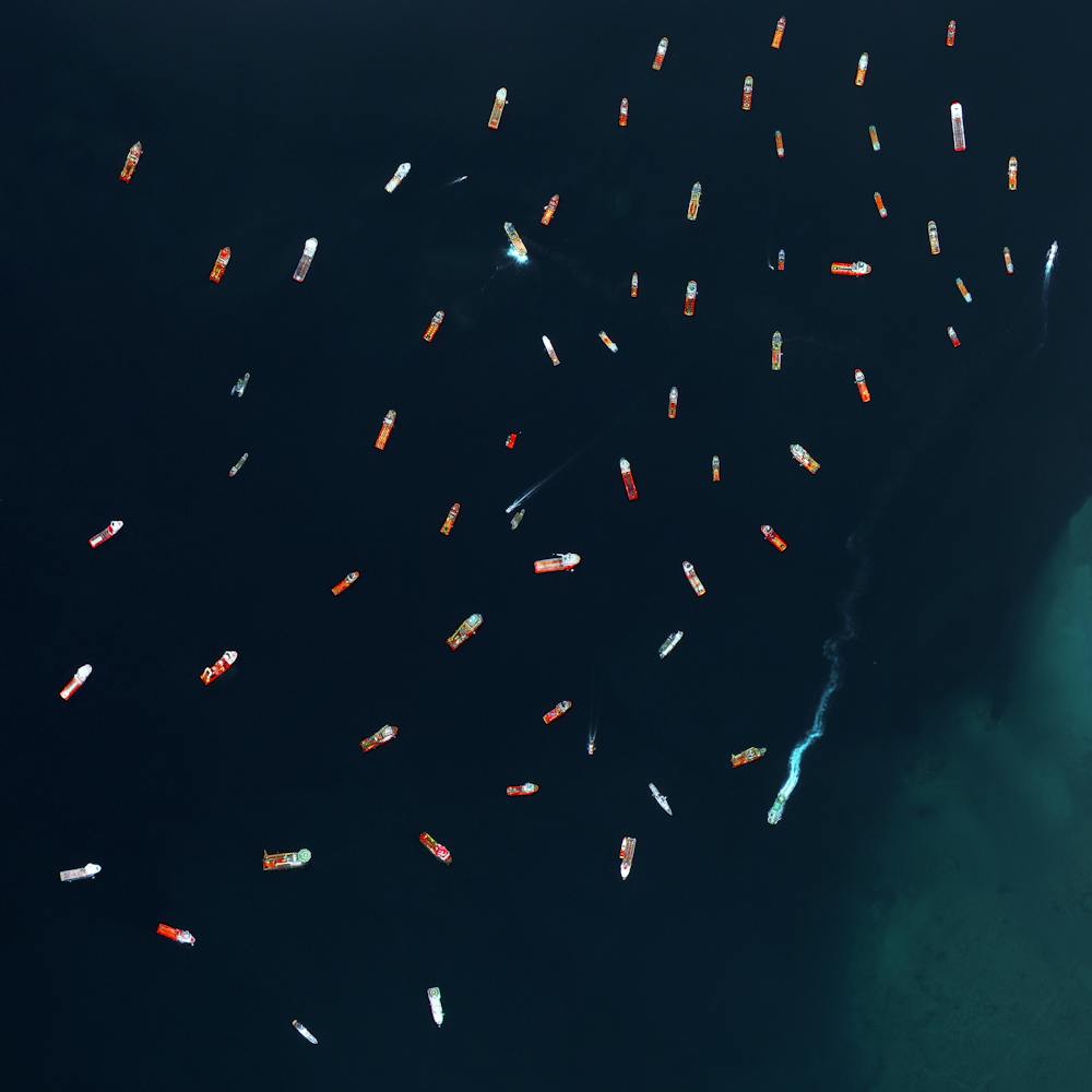
Oil platform
46.166667°, 51.583333° - Kashagan Field, Caspian Sea, KazakhstanTwo boats pass through the sea walls surrounding an oil extraction platform in Kazakhstan’s zone of the Caspian Sea. This area is known as the Kashagan Field, an offshore oil field that is estimated to have a recoverable reserve around 13 billion barrels of crude oil. However, due to harsh conditions - specifically sea ice during the winter, yearly temperature variation from −35 to 40 °C (−31 to 104 °F), extremely shallow water, and high levels of hydrogen sulfide that eventually need to be removed from the extracted oil - many consider it to be one of the most challenging oil megaprojects in the world.
Maxar Technologies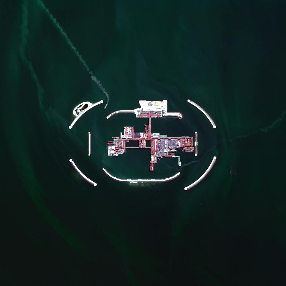
Olive trees
37.263212°, -4.552271° - Córdoba, SpainThis Overview captures olive tree plantations on the hills of Córdoba, Spain. Approximately 90% of all harvested olives are turned in to oil, while the other 10% are eaten as table olives.
Maxar Technologies
Omaha Beach
49.368889°, -0.868611° - Normandy, FranceOmaha Beach was one of five key targets in the Allied invasion of Normandy, France, during World War II. Today marks the 75th anniversary of this operation — now known as “D-Day" — which began the liberation of Nazi-occupied France. With its high cliffs, the 5-mile (8 km) stretch of Omaha Beach had heavier casualties than any of the other four targets -- Utah, Gold, Juno, and Sword.
Maxar Technologies
Oosterscheldekering
51.608691°, 3.681047° - Schouwen-Duiveland / Noord-Beveland, NetherlandsThe Oosterscheldekering (Eastern Scheldt storm surge barrier) is the largest in a series of 13 dams designed to protect the Netherlands from North Sea flooding. It spans about 5.6 miles (9 km) between the islands of Schouwen-Duiveland and Noord-Beveland, containing large sluicegate-type doors that can be closed under adverse weather conditions. Designed to last more than 200 years, the Oosterscheldekering is sometimes referred to as the eighth Wonder of the World.
Maxar Technologies
Øresund Bridge
55.570628°, 12.848637° - Denmark / SwedenStretching nearly 5 miles, the Øresund Bridge is the longest combined road and rail bridge in Europe. The bridge, which then becomes a tunnel, joins together two metropolitan areas — the Danish capital city of Copenhagen and the Swedish city of Malmö. The bridge itself has a mass of 82,000 tonnes and supports two railway tracks and four road lanes.
Maxar Technologies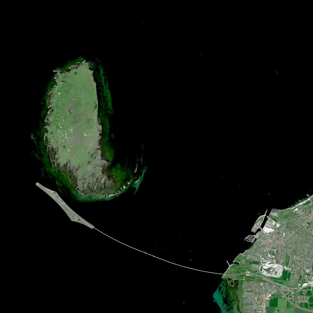
Orlando International Airport (MCO)
28.429444°, -81.308889° - Orlando, Florida, USAOrlando International Airport is a major public airport located six miles (10 km) southeast of Downtown Orlando, Florida. It is the busiest airport in Florida and the eleventh-busiest in the United States, handling more than 44.5 million passengers in 2017. Its hub-and-spoke layout features a large main terminal building surrounded by four airside concourses, with a total of 129 gates.
Nearmap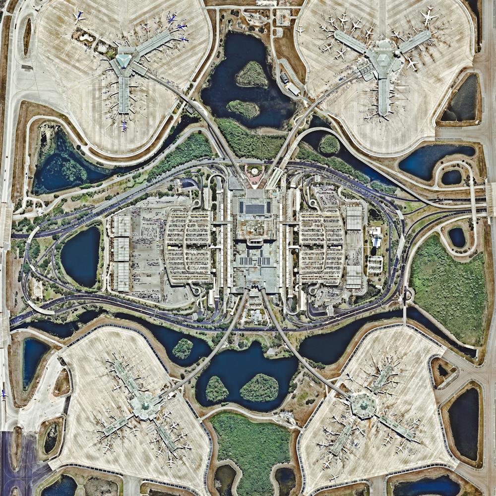
Oroville Dam Spillway
39.539222°, -121.496833° - California, USAWater rushes down the main spillway of the Oroville Dam, located on the Feather River in northern California. At 770 feet high (235m), the dam is the tallest in the United States and serves mainly for water supply, hydroelectricity generation, and flood control. Amid heavy rainfall in February 2017, this spillway was significantly damaged and more than 180,000 people living downstream were evacuated.
Nearmap
Östermalm
59.337571°, 18.088176° - Östermalm, SwedenÖstermalm is one of the largest districts in Stockholm, Sweden and contains the city’s most expensive real estate. The Swedish capital is spread across fourteen islands and has a population of 850,000 in its urban area.
Maxar Technologies
Ouarzazate Solar Power Station - Noor 3
31.009167°, -6.862222° - Ouarzazate, MoroccoNoor 3 is one of four sections of the Ouarzazate Solar Power Station in the Drâa-Tafilalet region of Morocco. The solar concentrator contains thousands of mirrors that focus the sun’s thermal energy to heat molten salt flowing through a massive central tower. The molten salt then circulates from the tower to a storage tank, where it is used to produce steam and generate electricity. This segment of the facility opened in spring of this year and is expected to begin delivering power to Morocco’s electricity grid by October.
Maxar Technologies