Explore
 Shop
Shop About
About Search
Overview Index
Moloka'i, Hawaii.
21.090000°, -157.225944° - Moloka'i, Hawaii, USAWaves roll into the shores of Moloka'i, Hawaii. At 260 square miles (673 sq. km), the volcanic island is the fifth largest of the Hawaiian Islands and contains some of the highest sea cliffs in the world. Moloka'i is known for its cattle ranches, pineapple farms, and is also a popular tourist destination. Want a copy of this Overview to hang in your home? It’s available for purchase in our Printshop! Head over to dailyoverview.com/printshop to find it and other prints for sale.
Maxar Technologies
Molokini Crater
20.632167°, -156.496167° - Hawaii, USAMolokini is a small, uninhabited islet located between the Hawaiian Islands of Maui and Kahoolawe. It is formed by a crescent-shaped, partially submerged volcanic crater roughly 0.4 miles (0.6 km) in diameter. A lush reef inside the Molokini Crater is home to about 250 species of fish, making it a popular destination for scuba divers and snorkelers.
Maxar Technologies
Mont Saint-Michel
48.636111°, -1.511389° - Normandy, FranceMont Saint-Michel is a commune located one kilometer off the coast of Normandy, France. Over the past 600 years, the island has functioned as a prominent monastery (accessible to pilgrims only during low tide), a French fortification that withstood England attacks during the Hundred Years’ War, and a prison. Today, Saint-Michel is one of the most popular tourist attractions in the country.
Maxar Technologies
Montauk Point Light
41.070961°, -71.856708° - Montauk, New York, USAMontauk Point Light is a lighthouse located at the easternmost point of Long Island in the hamlet of Montauk, New York. With its construction authorized by George Washington in April 1792, the building was the first of its kind in New York and is the fourth oldest active lighthouse in the United States.
Maxar Technologies
Monte Fitz Roy - Low Angle
-49.101972°, -73.034417° - Patagonia Argentina / ChileCheck out this amazing view of Monte Fitz Roy — a mountain in the Patagonia Region on the border of Argentina and Chile — captured by a Planet Labs satellite at a low angle. With an elevation of 11,171 ft (3,405 m) and sheer granite faces, it is one of the most technically challenging mountains to ascent on Earth. Monte Fitz Roy is also the inspiration for the Patagonia clothing company's logo.
Planet
Montevideo
-34.883611°, -56.181944° - Montevideo, UruguayMontevideo is the capital and most populous city of Uruguay, with about 1.3 million residents — more than one-third of the country's total population. It is also the southernmost capital city in the Americas, located southeast of Buenos Aires, Argentina, across the Río de la Plata. Montevideo is divided into 62 barrios (neighborhoods), each with its own identity, geographic location, and socio-cultural activities.
Maxar Technologies
Montreal Stadium
45.558000°, -73.552000° - Montreal, CanadaOlympic Stadium in Montreal, Canada was constructed for the 1976 Olympic Games. The stadium is home to the city's soccer and football teams and also features the world's largest inclined tower (574 feet). Hope all of our followers in Canada had a wonderful Canada Day yesterday!
Maxar Technologies
Moose River Tributaries
51.270826°, -80.929432° - Moosonee, Ontario, CanadaTributaries of the Moose River snake across snowy terrain near Moosonee, a town in northern Ontario, Canada. This area is part of the Hudson Plains Ecozone, a sparsely populated subarctic region extending from the western coast of Quebec to the coast of Manitoba. The ecozone contains the largest continuous wetland in the world, including the Moose River’s 41,900-square-mile (108,500 sq. km) drainage basin.
Maxar Technologies
Moscow, Russia
55.750000°, 37.616667° - 55.750000°, 37.616667°Moscow is the capital and most populous city in Russia with 13.2 million residents within the city limits and approximately 20 million in its metropolitan area. The city is organized into five concentric transportation rings that surround the Kremlin. The two innermost rings are seen here.
Maxar Technologies
Moselle Vineyards
49.837463°, 6.825530° - Trier-Saarburg, GermanyVineyards surround the Moselle River in the Trier-Saarburg district of Germany. The region is recognized for its production of Riesling wines with 9,000 hectares of land (roughly the size of Manhattan) dedicated to grape growing.
Maxar Technologies
Mossel Bay
-34.185460°, 22.146049° - Mossel Bay, South AfricaMossel Bay is located on the Cape St. Blaize Peninsula, jutting off of South Africa into the Indian Ocean. The harbor town is home to roughly 130,000 people and is recognized as a center for both tourism and agriculture.
Maxar Technologies
Mount Calvary Cemetery
40.633694°, -74.235028° - Linden, New Jersey, USAMount Calvary Cemetery is a cemetery in Linden, New Jersey, belonging to the St. Adalbert Roman Catholic Church. Saint Adalbert (Wojciech) is the patron saint of Poland and thus an important figure for many living in the city of Linden. More than 13% of residents there are of Polish origin and 15.6% of residents primarily speak Polish at home.
Nearmap
Mount Damāvand
35.955556°, 52.110000° - IranClouds circle the summit of Mount Damāvand, the highest peak in Iran with an elevation of 18,403 feet (5,609 m). As a potentially active stratovolcano, Mount Damāvand is also the highest volcanic mountain in Asia and part of the Volcanic Seven Summits mountaineering challenge. Located on the southern coast of the Caspian Sea, it is roughly 41 miles (66 km) northeast of Tehran.
Maxar Technologies
Mount Fuji
35.362727°, 138.730265° - Shizuoka / Yamanashi PrefecturesMount Fuji is an active stratovolcano and the tallest peak in Japan, rising 3,776 meters (12,389 feet). As seen in this Overview, Fuji has an extremely symmetrical cone, which is snow‑capped several months of the year. During warmer months, climbing routes make it possible for hundreds of thousands of people to scale the volcano each year.
Maxar Technologies
Mount Shasta
41.409167°, -122.195000° - Siskiyou County, CaliforniaMount Shasta is a potentially active volcano located in Siskiyou County, California, USA. At 14,179 feet, Mount Shasta is not connected to any nearby mountain and stands nearly 10,000 ft above the surrounding terrain.
Maxar Technologies
Mount Taranaki
-39.297166°, 174.063228° - Mount Egmont, New ZealandMount Taranaki, also known as Mount Egmont, is an active stratovolcano on the west coast of New Zealand’s North Island. A change in vegetation is sharply delineated between the protected national forest that encircles the volcano and the surrounding land comprised of intensively-farmed dairy pastures.
Maxar Technologies
Mount Taranaki
-39.296766°, 174.045846° - Taranaki, New ZealandMount Taranaki, also known as Mount Egmont, is an active stratovolcano on the west coast of New Zealand’s North Island. A change in vegetation is sharply delineated between the protected national forest that encircles the volcano and the surrounding land comprised of intensively-farmed dairy pastures.
Maxar Technologies
Mount Vernon Flower Nursery
48.445000°, -122.358361° - Mount Vernon, Washington, USAA variety of flowers, ornamental grasses, and other plants grow at a nursery in Mount Vernon, Washington — a small city roughly 60 miles (96 km) north of Seattle. Mount Vernon is the county seat of Skagit County, which has a climate similar to Northern France and thus yields millions of tulips every year.
Nearmap
Mount Vesuvius
40.822382°, 14.420151° - Campania, ItalyMount Vesuvius is a somma-stratovolcano located in Campania, Italy, about 5.6 miles (9 km) east of Naples. It is best known for its eruption in AD 79, which killed thousands and destroyed the Roman cities of Pompeii, Herculaneum, Oplontis and Stabiae. With an eruption as recent as 1944 and at least 3 million living nearby, Vesuvius is regarded as one of the most dangerous volcanoes in the world.
Maxar Technologies
MS Spirit of Tasmania
-37.847611°, 144.930583° - Melbourne, AustraliaThe MS Spirit of Tasmania backs away from a pier in the Port of Melbourne, Australia. This ferry makes daily trips to and from Melbourne and Devonport, Tasmania — a journey of roughly 9 hours. Tasmania is an island state of Australia, located 150 miles (240 km) to the south of the Australian mainland.
Nearmap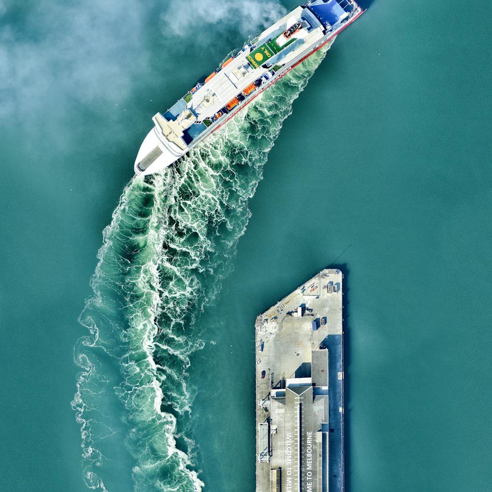
Munsu Water Park
39.039177°, 125.780009° - Pyongyang, North KoreaMunsu Water Park is located in Pyongyang, North Korea. The facility is open year-round with water slides, indoor and outdoor swimming pools, various sport courts, and a rock climbing wall.
Maxar Technologies
Murmansk
68.966667°, 33.083333° - Murmansk, RussiaMurmansk is a city located in the extreme northwest of Russia. With a population of nearly 300,000, it is the largest establishment north of the Arctic Circle. The record low temperature here is a blistering -39.4 degrees celsius (-38.9 degrees fahrenheit).
Maxar Technologies
Museum of Pop Culture
47.621500°, -122.348611° - Seattle, Washington, USAThe Museum of Pop Culture (also known as MoPOP) is a nonprofit museum in Seattle, Washington, dedicated to contemporary popular culture. Founded in 2000, it contains exhibits on fantasy, horror cinema, video games, science fiction, music and more. The museum’s unique, 140,000-square-foot (13,000 sq. meter) structure was designed by architect Frank Gehry.
Nearmap
Mussel nurseries
42.576312°, -8.859047° - Galicia, SpainMussel cultivation in the Ría de Arousa saline estuary off the coast of Galicia, Spain is the highest in the world. Floating rafts contain the nurseries where the mollusks grow on ropes until they are large enough to harvest. Mussel production has thrived here because there is an usually high concentration of phytoplankton in the water, providing the mussels with a protein-rich diet.
Maxar Technologies
Naarden
52.300000°, 5.166667° - Naarden, NetherlandsNaarden is a star fort in the Netherlands. The city was constructed in the manner seen here so that an attack on any individual wall could be defended from the two adjacent star points by shooting at the enemy from behind. Today Naarden is home to roughly 17,000 residents.
Maxar Technologies
Naples, Italy
40.845000°, 14.258333° - Naples, ItalyNaples is the third largest city in Italy with roughly one million residents. The metropolis is one of the oldest continuously inhabited areas in Europe with Bronze Age settlements established here in the second millennium BC. The historic city center, with its tightly gridded streets and numerous cathedrals, is captured in this Overview.
Maxar Technologies
Nardò Ring
40.327222°, 17.826111° - Nardò, ItalyThe Nardò Ring is a high speed, 7.8 mile long, circular test track in Nardò, Italy. Each of the ring’s four lanes has a determined “neutral speed” and is banked in such a manner that one can drive as if the road were straight.
Maxar Technologies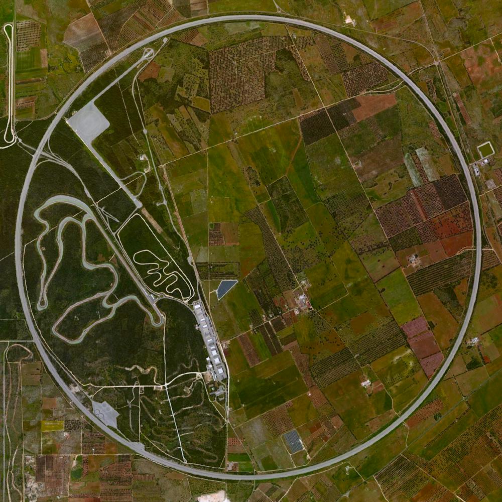
Naval Outlying Field Spencer
30.624667°, -87.139750° - Pace, Florida, USANaval Outlying Field Spencer is a military airport roughly two miles northeast of Pace, Florida, in Santa Rosa County. Centered on 640 acres, its eight equally-sized runways form two overlapping squares: one with corners pointing North, South, East and West, and another that is rotated 45 degrees.
Nearmap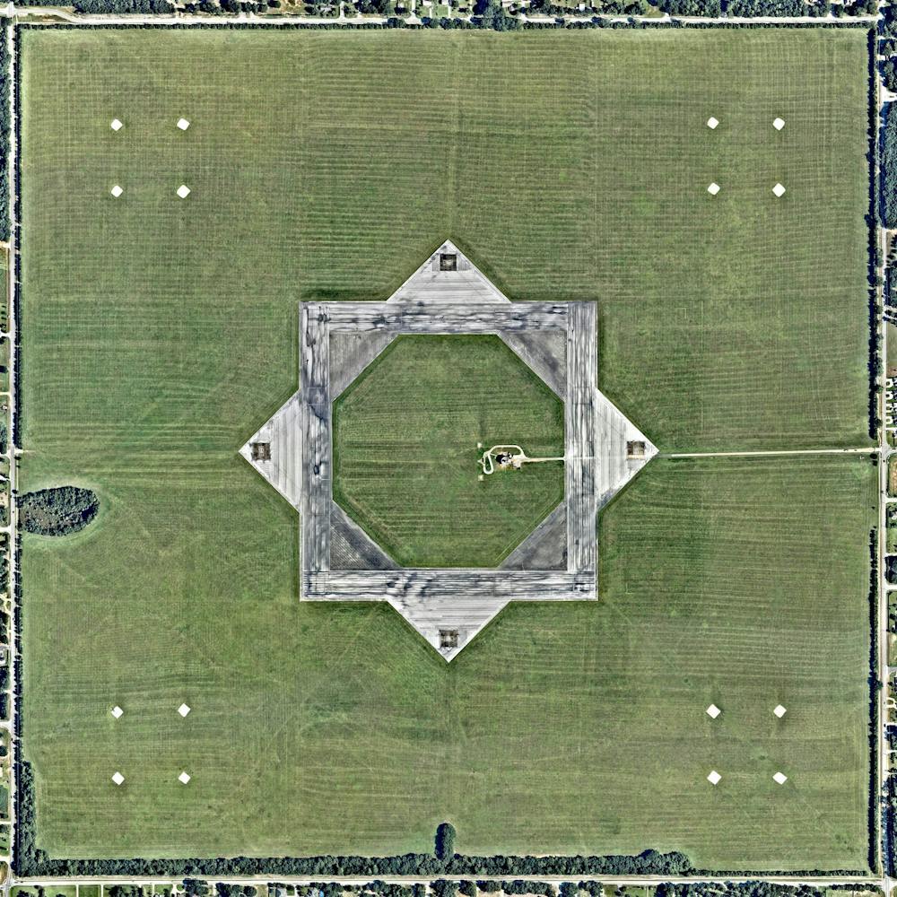
Nebraska Iowa Flooding (Juxtapose)
41.021611°, -95.849611° - Nebraska / Iowa, USAThese jaw-dropping juxtaposes shows farmland at the Nebraska-Iowa border before and after catastrophic flooding occurred there last week. Floods across the Missouri River Basin were caused by heavy rainfall and rapid snowmelt, and the total cost of damages in Nebraska has exceeded $1.3 billion. At least 2,000 homes and 340 businesses have been damaged or destroyed, and losses to infrastructure, farmland and livestock are monumental.
Maxar Technologies
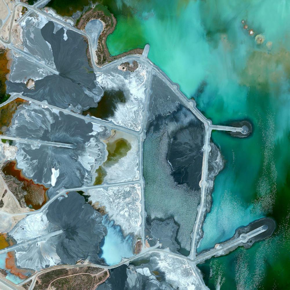
Neves-Corvo Mine
37.573056°, -7.970833° - Castro Verde Municipality, PortugalWaste ponds are seen at the Neves-Corvo Mine in the Castro Verde Municipality in Portugal. Zinc and copper and the primary resources extracted from the mine and the byproducts of that extraction is sent to these basins three kilometers away. Typically, once waste materials are pumped into a tailings pond, they are mixed with water to create a sloppy form of mud known as slurry. The slurry is then pumped through magnetic separation chambers to extract usable ore and increase the mine’s total output.
Maxar Technologies