Overview Index
Adriatic Tankers
45.315253°, 12.071250° - Venice, ItalyMassive oil tankers are dwarfed by the Adriatic Sea just outside the Port of Venice, Italy. Last year, 26.4 million tons of freight passed through the port — an increase of more than 1 million tons from 2017. Of this, at least 7.7 million tons was refined petroleum products, and much of the rest was dry bulk goods and containerized cargo.
Maxar Technologies
Beijing Capital International Airport (PEK)
40.078856°, 116.582160° - Beijing, ChinaBeijing Capital International Airport is the second busiest airport in the world, handling more than 90 million passengers every year. The dragon-like layout of the terminals is meant to celebrate the thrill and poetry of flight, while the orange roof evokes the vibrant coloration of the city’s famed Forbidden City.
Maxar Technologies
Boat on Inglis River
-40.985250°, 145.730194° - North West Tasmania, AustraliaA personal water craft speeds away from a pier on the Inglis River in North West Tasmania, Australia. The Inglis flows for roughly 38 miles (61 km) before emptying into the Bass Strait, the body of water that separates Tasmania from the Australian mainland.
Nearmap
Boeing 737 Max Parking Lot
47.529245°, -122.309162° - Seattle, Washington, USADozens of 737 MAX jetliners cover a parking lot at Boeing's factory in Seattle, Washington. This model has been grounded since March following two fatal crashes in less than six months. July was Boeing's fifth consecutive month without a new order for the 737 MAX and its least productive month for plane deliveries since November 2008.
Nearmap
Bosphorus Bridge
41.045278°, 29.034444° - Istanbul, TurkeyThe Bosphorus Bridge is one of two suspension bridges that connects Europe and Asia across the Bosphorus Strait in Istanbul, Turkey. Last night, members of the Turkish military closed down the bridges during an attempt to seize control from the ruling government. News media are now reporting that government forces have reasserted their control over the country.
Maxar Technologies
Car terminal
37.908562°, -122.367247° - Richmond, California, USACars are unloaded and parked at an automobile terminal in Richmond, California, USA. In 2015, 17.5 million cars and light trucks were sold in the United States, raising the total number of registered vehicles in the country to roughly 253 million.
Nearmap
Cars At Philadelphia Navy Yard
39.894037°, -75.179375° - Philadelphia, Pennsylvania, USAThousands of automobiles fill a large lot near the Philadelphia Navy Yard in southern Philadelphia, Pennsylvania. Since 2010, when Hyundai and Kia Motors moved their import businesses to the city, several large lots like this have popped up to accommodate an influx of new vehicles. At least 120,000 vehicles a year have arrived at the Port of Philadelphia since 2011, and more than 155,000 were delivered in 2015.
Nearmap
Central de Abasto
19.373908°, -99.088439° - 19.373908°, -99.088439°Thousands of trucks and cars surround the Central de Abasto — Mexico City’s largest wholesale market for produce and other foodstuffs. The market serves more than 300,000 people and handles over 30,000 tons of merchandise each day — representing 80% of the consumption of the Mexico City metropolitan area.
Maxar Technologies
Channel Tunnel
50.931745°, 1.824168° - Calais, FranceTrucks sit by the entrance of the Channel Tunnel in Calais, France. in an effort to get to Britain - 31.4 miles away via the underwater passage. This is the latest incident in an ongoing crisis in Europe where an estimated 100,000 migrants have entered the continent to flee violence and poverty in neighboring regions.
Maxar Technologies
Chicago Midway International Airport (MDW)
41.786775°, -87.752188° - Chicago, Illinois, USAChicago Midway International Airport is a major commercial airport on the southwest side of Chicago, Illinois. It was the city's primary airport from the time it opened in 1927 until 1955, when O'Hare International Airport was opened roughly 20 miles (32 km) to its north. Located on one square mile (2.59 sq. km), Midway remains the second-busiest airport in the state of Illinois, having served 22 million passengers in 2018.
Maxar Technologies
Chicago O'Hare International Airport (ORD)
41.978806°, -87.902833° - Chicago, Illinois, USAO'Hare International Airport — located in the far northwest corner of Chicago, Illinois — is the sixth-busiest passenger airport in the world. It provides direct flights to 217 destinations in North America, South America, Asia, Africa and Europe. In 2017, O'Hare served more than 79.8 million passengers.
Nearmap
Chicago Tractor-Trailer Hub
41.750750°, -87.878611° - Hodgkins, Illinois, USATrailers are docked and loaded at the Chicago Area Consolidation Hub, a package sorting facility in Hodgkins, Illinois. This 1.5 million square foot (139,355 sq. m) facility is owned by the United Parcel Service (UPS) and handles packages traveling throughout the United States and world. Roughly 1.5 million packages pass through its more than 65 miles (105 km) of conveyor belts every day.
Nearmap
Chino Airport Retired Airplanes
33.975160°, -117.635251° - San Bernardino County, California, USAA variety of retired aircraft sit on display at Chino Airport in San Bernardino County, California. The airport played an important role during World War II when it housed the Cal-Aero Academy, a flight training school for Army Air Cadets. After the war, hundreds of combat aircraft were brought to Chino for disposal; but many have been restored by two on-site aircraft museums — the Planes of Fame and the Yanks Air Museum.
Nearmap
Cloverleaf interchange
25.174690°, 51.326337° - Doha, QatarA cloverleaf interchange is constructed on the outskirts of Doha, Qatar. The objective of a cloverleaf is to allow two highways to cross without the need to stop traffic.
Maxar Technologies
Cloverleaf Interchange
42.848854°, -85.678458° - Grand Rapids, Michigan, USAA cloverleaf interchange is formed at the intersection of U.S. Route 131 and the Paul B. Henry Freeway in Grand Rapids, Michigan, USA. Safe travels to everyone who will be out on the roads this weekend for the holiday!
Maxar Technologies
Coal trains
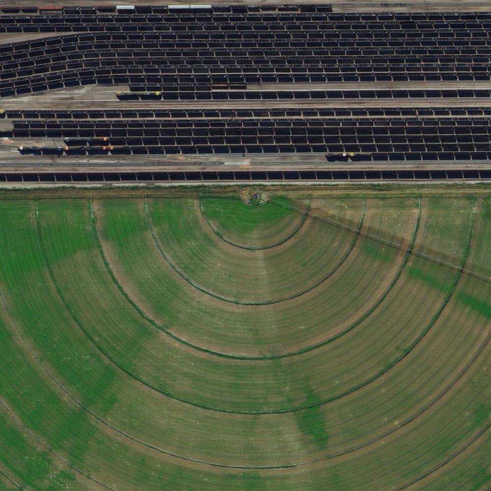
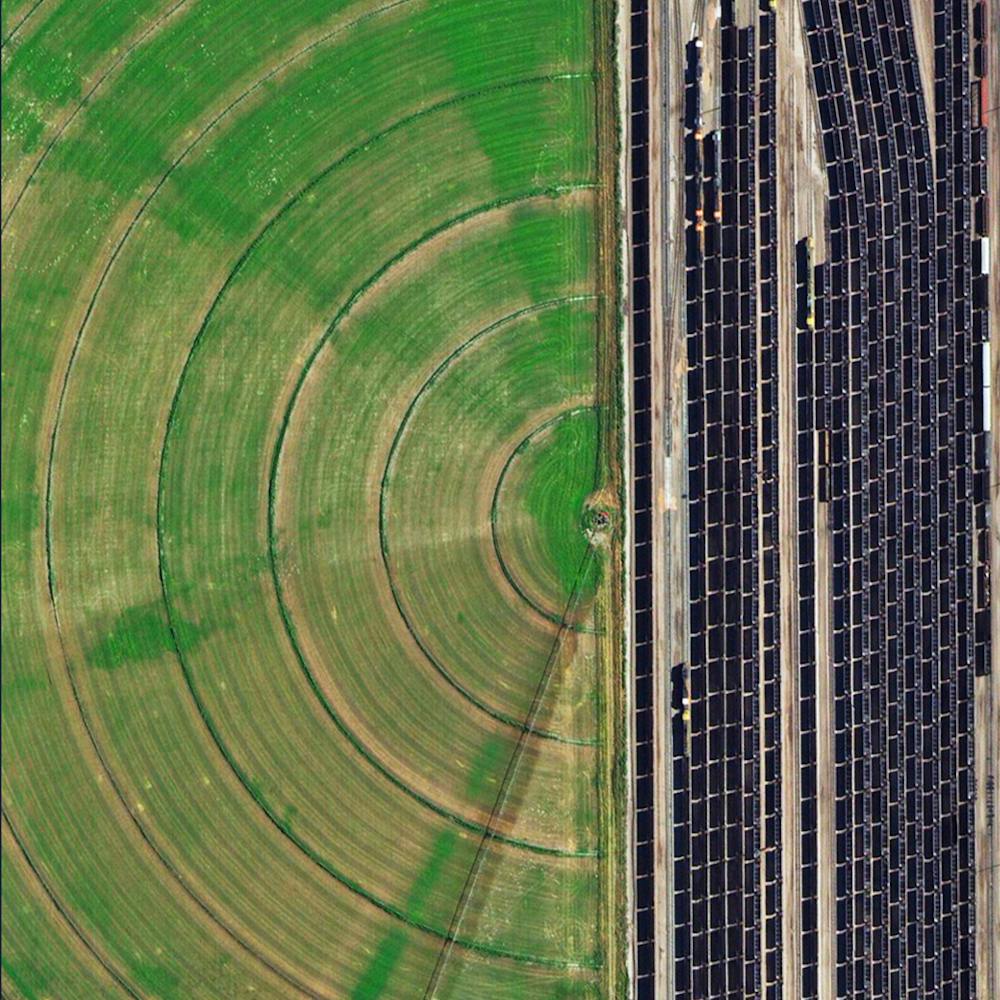
42.082523°, -102.890046° - Alliance, Nebraska, USACoal trains - some full, others empty - idle in a railyard next to a pivot irrigation circle in Alliance, Nebraska, USA. The city is located in the Powder River Basin - one of the world’s largest coal-mining areas - and serves as a stopping point for trains en route to power plants in the Midwest and Southern parts of the country.
Maxar Technologies
Coal Trains in Alliance, Nebraska
42.082523°, -102.890045° - 42.082523°, -102.890045°Coal trains — some full, others empty — idle in a railyard next to a pivot irrigation circle in Alliance, Nebraska, USA. The city is located in the Powder River Basin — one of the world’s largest coal-mining areas — and serves as a stopping point for trains en route to power plants in the Midwest and Southern parts of the country.
Maxar Technologies
Dallas/Fort Worth International Airport (DFW)
32.896944°, -97.038056° - Dallas, Texas, USADallas/Fort Worth International Airport covers more than 27 square miles (70 sq. km) in Texas — an area larger than the island of Manhattan. It is the fourth busiest airport in the world by aircraft movements and the 14th busiest in the world in terms of passenger traffic, handling 69.1 million travelers in 2018.
Maxar Technologies
Davis–Monthan AFB
32.150574°, -110.827969° - Tuscon, ArizonaThe largest aircraft storage and preservation facility in the world is located at Davis–Monthan Air Force Base in Tucson, Arizona. The facility - run by the 309th Aerospace Maintenance and Regeneration Group - contains more than 4,400 retired American military and government aircraft.
Nearmap
Davis-Monthan Air Force Base
32.171449°, -110.848683° - Tucson, Arizona, USAThe largest aircraft storage and preservation facility in the world is located at Davis–Monthan Air Force Base in Tucson, Arizona. The facility - run by the 309th Aerospace Maintenance and Regeneration Group - contains more than 4,400 retired American military and government aircraft.
Maxar Technologies
Davis-Monthan Air Force Base Aircraft Boneyard
32.151087°, -110.826079° - Tucson, Arizona, USAThe largest aircraft storage and preservation facility in the world is located at Davis-Monthan Air Force Base in Tucson, Arizona, USA. The boneyard—run by the 309th Airspace Maintenance and Regeneration Group—contains more than 4,400 retired American military and government aircraft.
Maxar Technologies
Denver International Airport
39.861667°, -104.673056° - Denver, Colorado, USADenver International Airport in Colorado covers more than 33,000 acres (52 square miles), making it is the largest airport in the United States by total land area. The facility is the 18th-busiest airport in the world and the 6th busiest in the United States by passenger traffic with more than 54 million passengers.
Maxar Technologies
Detroit Metropolitan Airport (DTW)
42.212500°, -83.353333° - Romulus, MichiganDetroit Metropolitan Airport covers more than 11 square miles in Romulus, Michigan. Concourse A at McNamara Terminal, seen here at left, is the world's second-longest airport terminal building, extending a length of one mile (Kansai Airport in Japan has a 1.7 mile long terminal). Detroit Metro is the 16th busiest facility in the United States, serving more than 32 million passengers each year.
Maxar Technologies
Dubai Whirlpool Interchange
25.055816°, 55.248835° - 25.055363°, 55.248780°A whirlpool interchange connects three major roads by the Miracle Garden in Dubai, United Arab Emirates. When construction of this junction began in 2006, Dubai contained 30,000 industrial cranes — 25% of all cranes on the planet.
Maxar Technologies
DuSable Harbor
41.885597°, -87.611850° - Chicago, Illinois, USASailboats are docked at DuSable Harbor in Chicago, Illinois, USA. The facility is located on Lake Michigan in the heart of the city’s downtown area and contains 420 slips for boats between 30 to 60 feet in length.
Nearmap
Elliott Bay Marina
47.628735°, -122.387261° - Seattle, Washington, USABoats and buoys are moored at Elliott Bay Marina, a private marina in Seattle, Washington. Located in the city’s Magnolia neighborhood, it has 1,250 slips ranging in size from 32 to 63 feet (9.75 to 19.2 meters) and 10 miles (16 km) of docks.
Nearmap
Fallon Range Training Complex
39.878094°, -118.398102° - Dixie Valley, Nevada, USAThe Fallon Range Training Complex is a United States Navy military area that spans 84,000 acres in the Dixie Valley of Nevada, USA. The complex primarily hosts air-to-air and air-to-ground training exercises. Here we see an installation of metal containers that are used for covert operations training as well as instrument recognition and calibration for spy planes and satellites.
Maxar Technologies
Frankfurt Airport
50.033333°, 8.570556° - Frankfurt, GermanyFrankfurt Airport is the busiest airport in Germany, averaging 1,365 flights per day and 65 million passengers per year. With more than 70,000 employees, the airport it is also the single largest workplace in the country.
Maxar Technologies
French Frigate Shoals Airport
23.748888°, -166.154887° - French Frigate Shoals, Hawaii, USAFrench Frigate Shoals Airport is a private airfield on Tern Island in French Frigate Shoals, Hawaii. Located roughly 560 miles northwest of Honolulu, the airport has a coral surface that is 3,000 feet long, 200 feet wide, and sits just six feet above sea level. It is owned by the U.S. Fish and Wildlife Service and is only used for emergencies.
Maxar Technologies
Gibraltar International Airport (GIB)
36.151111°, -5.349722° - GibraltarThe Overview captures the Gibraltar International Airport, serving the British overseas territory and neighboring areas of southern Spain. Winston Churchill Avenue - the road to the border with Spain - intersects the airport runway and has to be closed every time a plane lands or departs.
Maxar Technologies