Overview Index
Adventuredome
36.138056°, -115.167389° - Las Vegas, Nevada, USAAdventuredome is a five-acre indoor amusement park on the Las Vegas Strip in Nevada, USA. The facility's main structure consists of more than 350,000 square feet of pink insulated glass. Inside are two roller coasters, a water ride, rock climbing wall, 18-hole miniature golf course and dozens of carnival games.
Nearmap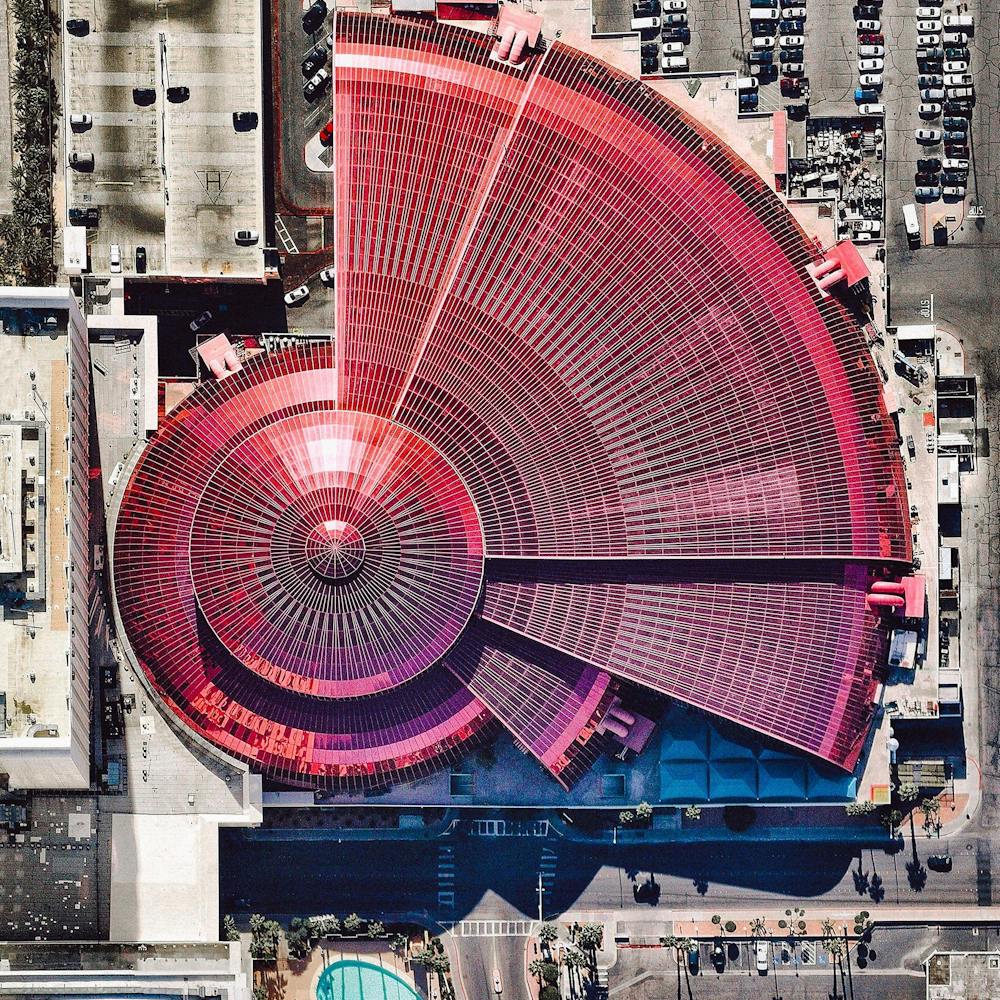
Al Falah Housing Project
24.445187°, 54.719998° - Abu Dhabi, United Arab EmiratesThe Al Falah Housing Project is located in Abu Dhabi, United Arab Emirates. The development covers 12.5 million square meters with 4,857 villas as well as mosques, schools, a shopping mall, and a hospital.
Maxar Technologies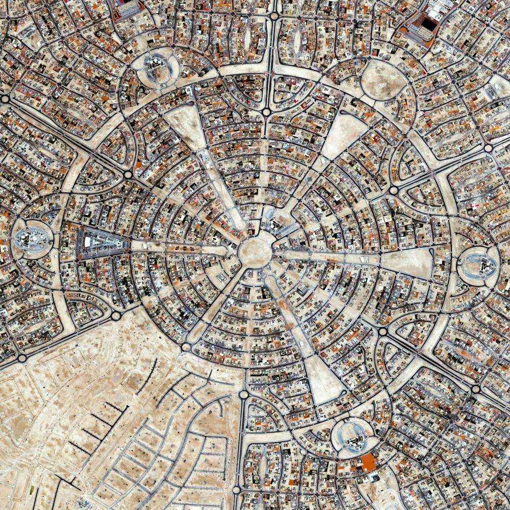
Ancient Ruins of Palmyra
34.547438°, 38.274651° - Palmyra, SyriaIn the past week, fighters from the Islamic State seized the ancient oasis city of Palmyra, Syria. Located at the crossroads of ancient Greek, Roman, Persian, and Islamic cultures, the city contains some of the world’s oldest known antiquities and ruins. The fabled amphitheater and the Temple of Bel seen in this Overview were completed as far back as 32 AD. ISIS despises antiquity since it represents culture that predates Islam and experts predict that they will vandalize and destroy these ancient ruins.
Maxar Technologies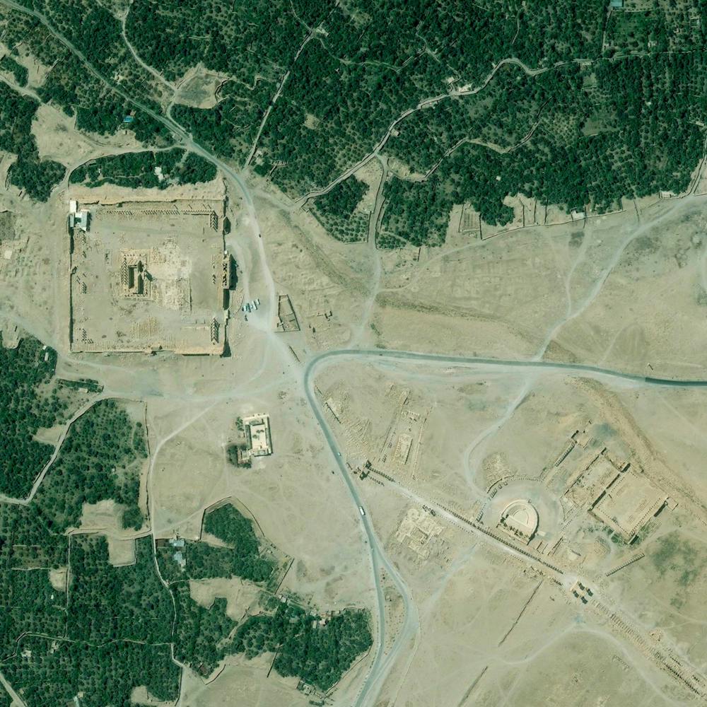
Angkor Wat
13.412500°, 103.866667° - Angkor, CambodiaAngkor Wat is a temple complex in Cambodia that is the largest religious monument in the world (first it was Hindu, then Buddhist). Constructed in the 12th century, the 820,000 square meter site features a moat and forest that harmoniously surround a massive temple at its center.
Maxar Technologies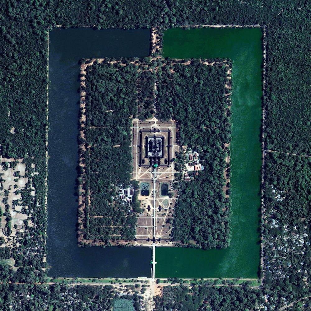
Apple Park
37.334185°, -122.009930° - Cupertino, California, USAApple Park is the corporate headquarters of Apple Inc., located in Cupertino, California, USA. It was opened to employees in April 2017, superseding the original "Apple Campus," which opened in 1993. Currently, more than 12,000 employees work in the four-story office building, which has a circumference of 1 mile (1.6 km) and a floor area of 2.8 million square feet (260,000 square meters).
Nearmap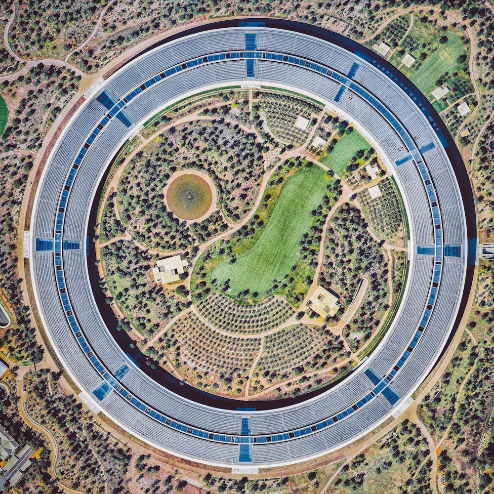
Arc De Triomphe
48.873778°, 2.295000° - Paris, FranceThe Arc de Triomphe is located at the center of 12 radiating avenues in Paris, France. Yesterday, millions took to these streets to celebrate France’s second FIFA World Cup victory (with a 4-2 final win over Croatia). Today, players and coaches will parade up the Champs-Elysees avenue, which passes diagonally through this Overview from bottom left to upper right.
Maxar Technologies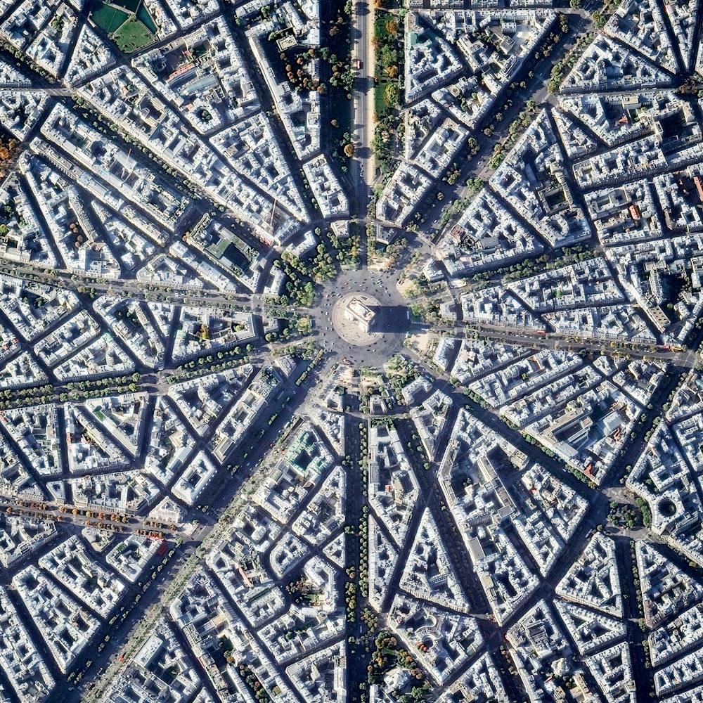
Arecibo Observatory
18.344167°, -66.752778° - Arecibo, Puerto RicoThe Arecibo Observatory is a radio telescope in the municipality of Arecibo, Puerto Rico. The telescope, which is 1,000 feet (305 m) in diameter, is used for three major areas of research — radio astronomy, atmospheric science, and radar astronomy. Last year, high winds associated with Hurricane Maria caused a line feed on the telescope to break and fall onto the primary dish, damaging about 30 of its 38,000 aluminum panels.
Maxar Technologies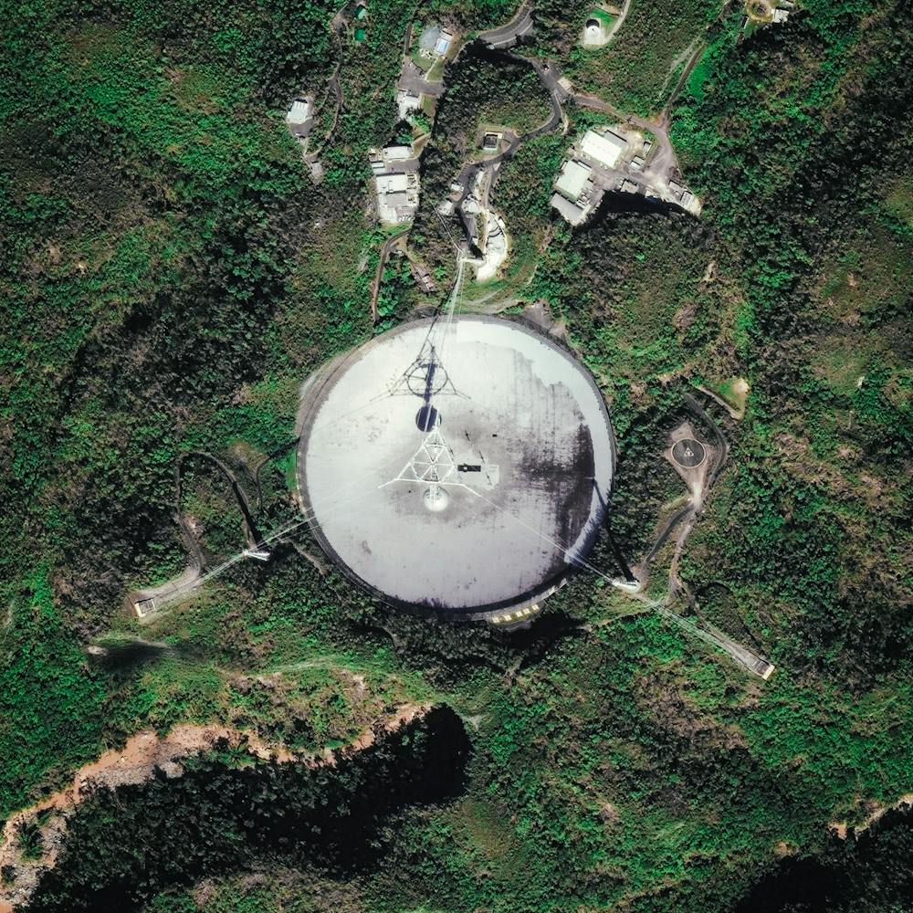
Arizona State Prison Complex - Perryville
33.470556°, -112.441667° - Goodyear, Arizona, USAThe Arizona Department of Corrections facility in Goodyear, Arizona is surrounded by fields of lettuce, cabbage, and red potatoes. The prison holds 2,382 inmates across eight housing units (only one is pictured here). This Overview is part of a collaborative photo essay that we just released with Fusion to detail how prisons have become a part of the American landscape, often in plain sight. Check out the full story .
Maxar Technologies
Arlington National Cemetery
38.878325°, -77.068671° - Arlington, Virginia, USAThe Arlington National Cemetery's Columbarium, located in Arlington, Virginia, was opened in April 1980 as a resting place for cremated remains. It has nine courtyards and contains about 50,000 niches, with each niche accommodating up to two urns. The Columbarium is found in the southeast section of the cemetery, about a half-mile (0.8 km) from the Memorial Gate.
Nearmap
Atacama Large Millimeter Array
-23.027784°, -67.754811° - Atacama Desert, ChileThe Atacama Large Millimeter Array (ALMA) is a collection of radio telescopes in the Atacama desert of northern Chile. Completed in 2013 with 66 12-meter (39 ft), and 7-meter (23 ft) diameter radio telescopes, the facility aims to provide insights on star birth during the early universe and detailed images of planet formation.
Maxar Technologies
Berlin
52.534336°, 13.425719° - Berlin, GermanyThe magnificent architecture of the Winsviertel and Bötzowviertel quarters, both located within Prenzlauer Berg, Berlin are captured in this Overview.
Maxar Technologies
Blooming tulips
52.384722°, 5.399772° - Zeewolde, NetherlandsBlooming tulips are seen among the fields of Zeewolde, Netherlands. The country is the world leader in tulip production, growing an estimated 4.3 billion bulbs each year, 2.3 billion of which are made into cut flowers.
Maxar Technologies
Bosphorus Bridge
41.045278°, 29.034444° - Istanbul, TurkeyThe Bosphorus Bridge is one of two suspension bridges that connects Europe and Asia across the Bosphorus Strait in Istanbul, Turkey. Last night, members of the Turkish military closed down the bridges during an attempt to seize control from the ruling government. News media are now reporting that government forces have reasserted their control over the country.
Maxar Technologies
Bourtange
53.006600°, 7.192000° - Bourtange, NetherlandsBourtange is a star fort located in the Groningen Province of the Netherlands. It was constructed in 1593, during the Eighty Years’ War, to control the only road between Germany and the city of Groningen. Today, the fort serves as a historical museum and the surrounding village of Bourtange has an population of 430.
Maxar Technologies
Brock Reservoir
32.716000°, -115.036000° - Gordons Well, California, USAThe Brock Reservoir - located near Gordons Well, California, USA - is used to supply water to nearby farmers via the All-American Canal. Compared to other reservoirs, Brock’s capacity is relatively small with storage for only 2,600 million US gallons. Since 2013, reservoirs across the state of California has experienced a significant reduction in water levels, with more than 80% of land experiencing severe to exceptional drought.
Maxar Technologies
Brøndby Haveby
55.637185°, 12.399623° - 55.637185°, 12.399623°Brøndby Haveby is an associated community located just outside of Copenhagen, Denmark. Houses with large front yards are centered around cul-de-sacs, providing urban dwellers the opportunity to live outside the city and grow small subsistence or hobby crops during the summer months.
Maxar Technologies
Burj Khalifa
25.197139°, 55.274111° - Dubai, United Arab EmiratesStanding at 2,717 feet (828m), the Burj Khalifa in Dubai, UAE is the tallest building in the world (and casts quite a long shadow!). The design of the 163-floor structure is an abstraction of the Hymenocallis, a type of desert flower that has long petals extending from its center. The building has been very well received since it opened in 2010; however, its construction was very controversial as it was built primarily by workers from South Asia and East Asia who earned low wages and were housed in abysmal conditions.
Maxar Technologies
Burning Man
40.786944°, -119.204444° - Black Rock City, Nevada, USAOver the next few days, thousands of people from around the world will head to the desert in Nevada, USA to construct Black Rock City. Laid out in a grid plan with radiating avenues named after the numbers on a clock, the city serves as home to roughly 60,000 people for Burning Man, an annual week-long event. Burning Man is described as an experiment in community, art, self-expression, and radical self-reliance. Additionally residents in Black Rock City practice one of the event's key principles of ‘Leave No Trace’ – meaning significant efforts are taken to make sure as the city is disassembled in the days following the festival, the desert returns to its original state.
Maxar Technologies
Cape Coral
26.604391°, -81.000000° - Cape Coral, FloridaBecause many cities in the state of Florida contain master-planned communities, often built on top of waterways in the latter half of the twentieth century, there are a number of intricate designs that are visible from the Overview perspective. Here is one particular development in Cape Coral, a city with a population of 165,831 people.
Maxar Technologies
Capital Hill
-35.308056°, 149.124444° - Canberra, AustraliaThe construction of Parliament House in Canberra, Australia involved the removal of the top half of Capital Hill (the mound on which the structure was built). After the project was completed, much of the displaced earth was replaced on top of the building where a lush, green lawn now grows. While much of Canberra was designed by by Walter Burley Griffin in 1913, this specific complex opened in 1988, is designed to look like two boomerangs, and contains approximately 4,400 rooms.
Maxar Technologies
Central Park
40.782222°, -73.965278° - New York, New York, USAThis Overview captures Central Park in New York City. Located in the middle of Manhattan, the park spans 843 acres — or 6% of the borough. One of the most influential innovations in the park's design was its "separate circulation" systems for pedestrians, horseback riders, and automobiles. This concealed "crosstown" commercial traffic in sunken roadways (known as "transverses" today), and densely planted shrub belts in order to maintain a rustic ambiance.
Maxar Technologies
Chinese Radio Telescope
25.652920°, 106.856580° - 25.652920°, 106.856580°The Five-hundred-meter Aperture Spherical Telescope is a radio telescope in the limestone hills of China’s Guizhou province. With a dish 1,600 feet (500 m) in diameter, it is the world’s largest filled-aperture radio telescope and the second-largest single-dish aperture, behind Russia’s RATAN-600.
Maxar Technologies
Cimetière Parisien de Pantin
48.904842°, 2.410054° - Paris, FranceCimetière parisien de Pantin is the largest cemetery in Paris, France, both in number of graves and land area. Since opening in November 1886, more than one million people have been buried here, with nearly 5,000 interments taking place each year. Pantin is a garden-style burial ground, with more than 8,000 trees and a network of 20 miles (32 km) of roads that allow motor vehicle access.
Geomni Map Pros
Copenhagen Kastellet
55.691417°, 12.595528° - Copenhagen, DenmarkKastellet — or “The Citadel” in English — is a star fortress located in Copenhagen, Denmark. It was built in October 1664 as part of a continuous ring of star forts surrounding the city, and it remains one of the best preserved ramparts of its kind in Northern Europe. Kastellet still houses some Danish military operations today, though it primarily serves as a public park and historic site.
Maxar Technologies
Cypress Village
33.691889°, -117.759139° - Irvine, California, USAUniform apartment buildings are seen here at Cypress Village, a township in Irvine, California. As a master-planned city, Irvine contains dozens of communities like this — each one having houses of a similar design, along with commercial centers, religious institutions, and schools. Irvine is one of the wealthiest cities in the western United States, with a median household income of $90,743 and a median home value of $784,500.
Nearmap
Del Ray Beach
26.476432°, -80.155327° - Del Ray Beach, Florida, USAThis Overview captures residential communities in Delray Beach, Florida, USA. According to the 2010 census, 20.4% of the town’s 34,156 households are vacant.
Maxar Technologies
Del Ray Beach
26.475548°, -80.156470° - Del Ray Beach, Florida, USAA residential community is seen here in Delray Beach, Florida, USA. Because many cities in the state of Florida contain master-planned communities, often built on top of waterways in the latter half of the twentieth century, there are a number of intricate designs such as this one that are visible from the Overview perspective.
Maxar Technologies
Desert Breath
27.380339°, 33.632154° - Hurghada, EgyptDesert Breath” - located in the Egyptian desert near Hurghada on the Red Sea - is a double-spiral art piece. Because the 89 protruding cones that make up one spiral are constructed from the sand that was dug to create the 89 depressed cones of the other spiral, in due time, with erosion, the area of approximately one million square feet will revert back to its original state.
Maxar Technologies
Eastern State Penitentiary
39.968390°, -75.172652° - Philadelphia, PennsylvaniaThe haunted house at the Eastern State Penitentiary in Philadelphia, Pennsylvania is consistently ranked among the scariest Halloween attractions in the United States. The prison operated from 1829 until 1971 and housed notorious criminals like the gangster Al Capone. The facility was also the first of its kind to be constructed in a “wagon-wheel” layout with seven wings of cellblocks radiating from a central hub. Hope everyone has a safe and scary Halloween!
Nearmap
Eixample District - Barcelona
41.392184°, 2.164928° - Barcelona, SpainThe Eixample district in Barcelona, Spain, is characterized by its strict grid pattern and apartments with communal courtyards. This thoughtful and visionary design was the work of Ildefons Cerdà. His plan features broad streets that widen at octagonal intersections to create greater visibility with increased sunlight, better ventilation, and more space for short-term parking.
Maxar Technologies