Daily
One regular dose of Earth from above
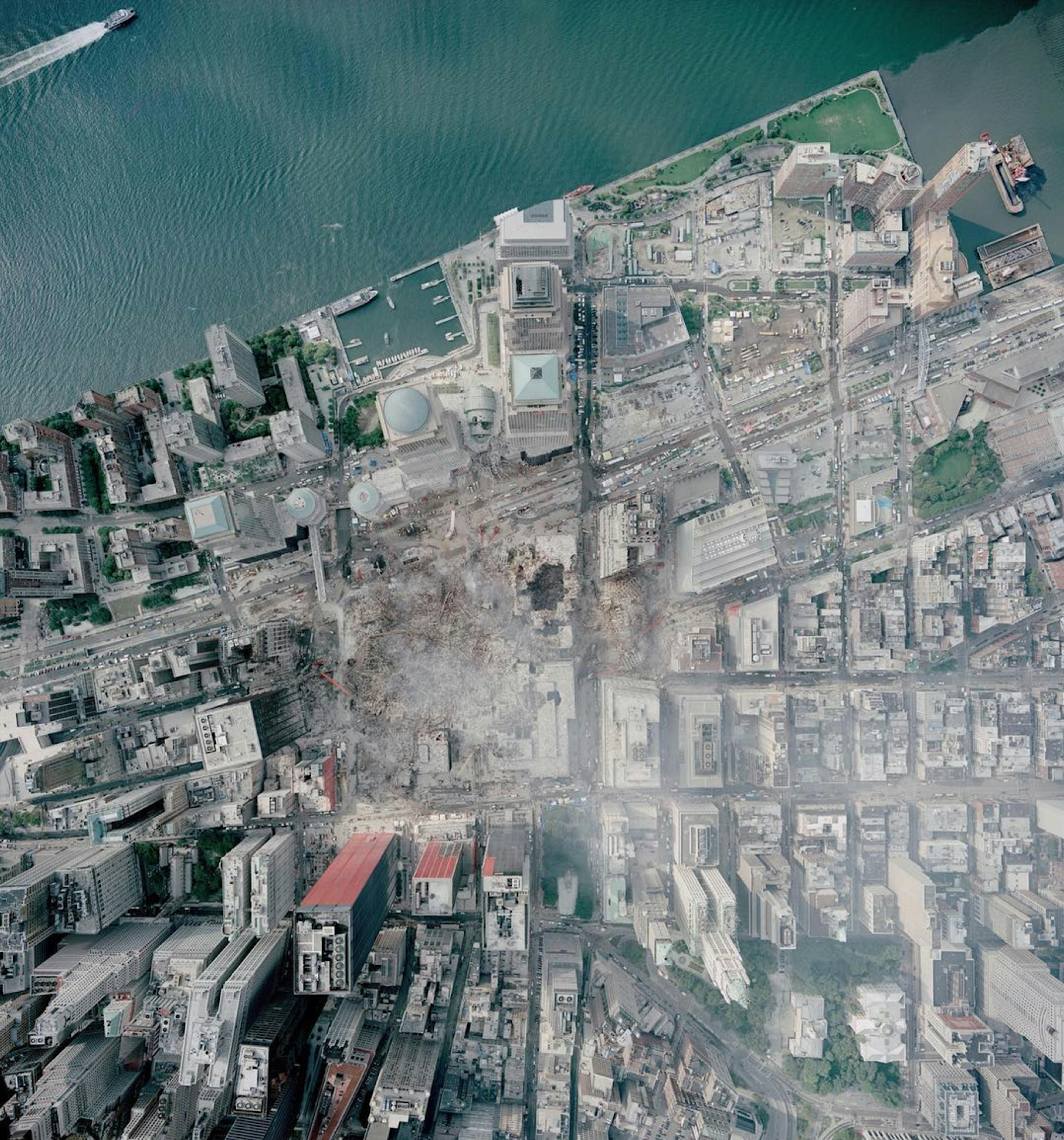
World Trade Center Aftermath
40.711596°,-74.013218° - NOAA
This Overview was captured above Ground Zero in downtown Manhattan on September 23, 2001. Today, on the 22nd anniversary of the 9/11 attacks, we pay tribute to the victims, survivors, first responders and families affected. We hope this memory serves as a reminder of how essential it is to foster an appreciation and love for our fellow man.
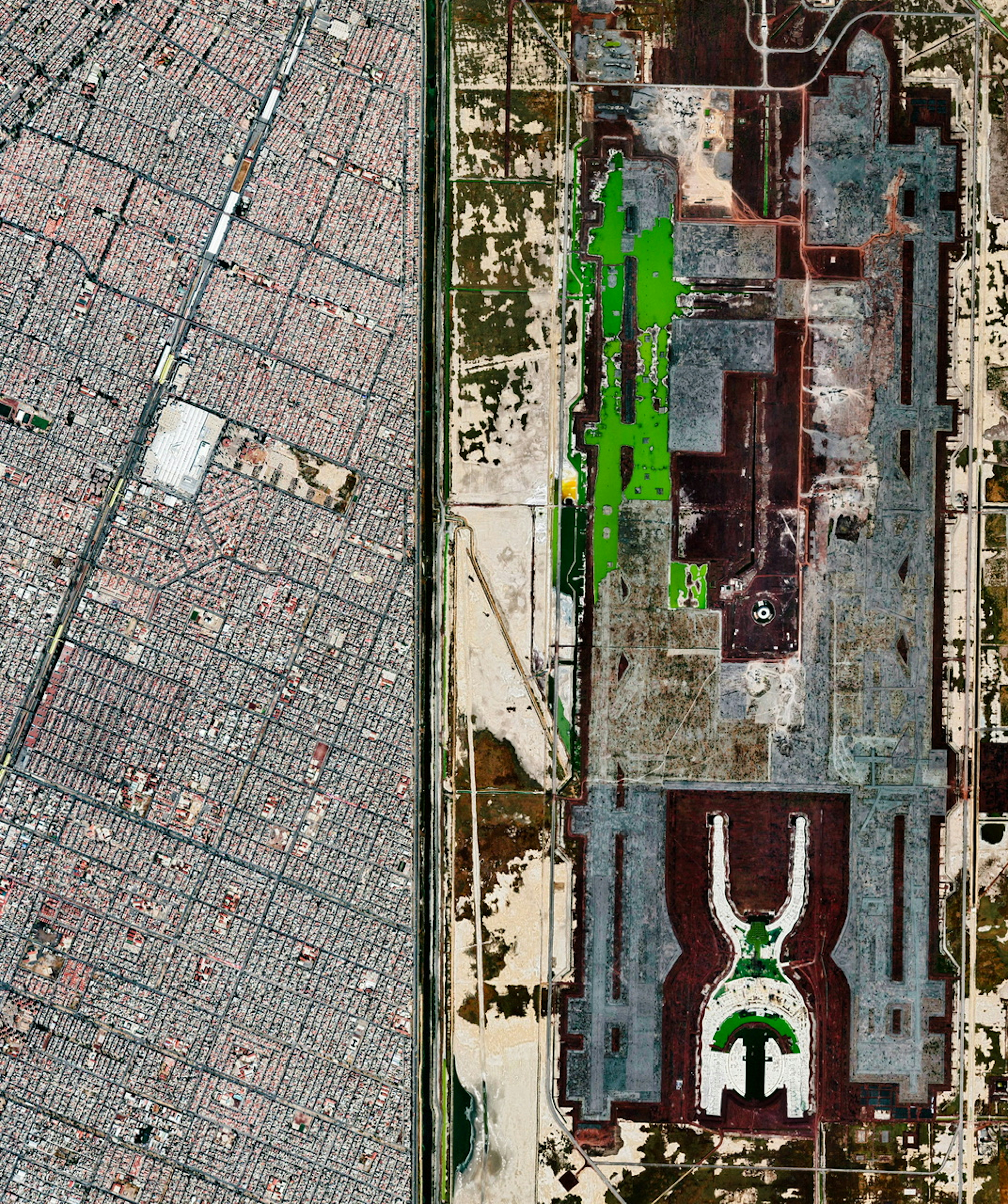
Mexico City Texcoco Airport
19.500000°,-98.997500° - Maxar
Crowded blocks of Mexico City run adjacent to the abandoned site of Mexico City Texcoco Airport, a planned airport that was never finished. In 2018, after years of construction, a referendum passed in favor of moving the US$13.3 billion project to a new location. As a result, Felipe Ángeles International Airport was constructed further north of the city (and opened in 2022), and the site shown here is slated to become an ecological park and restoration area.
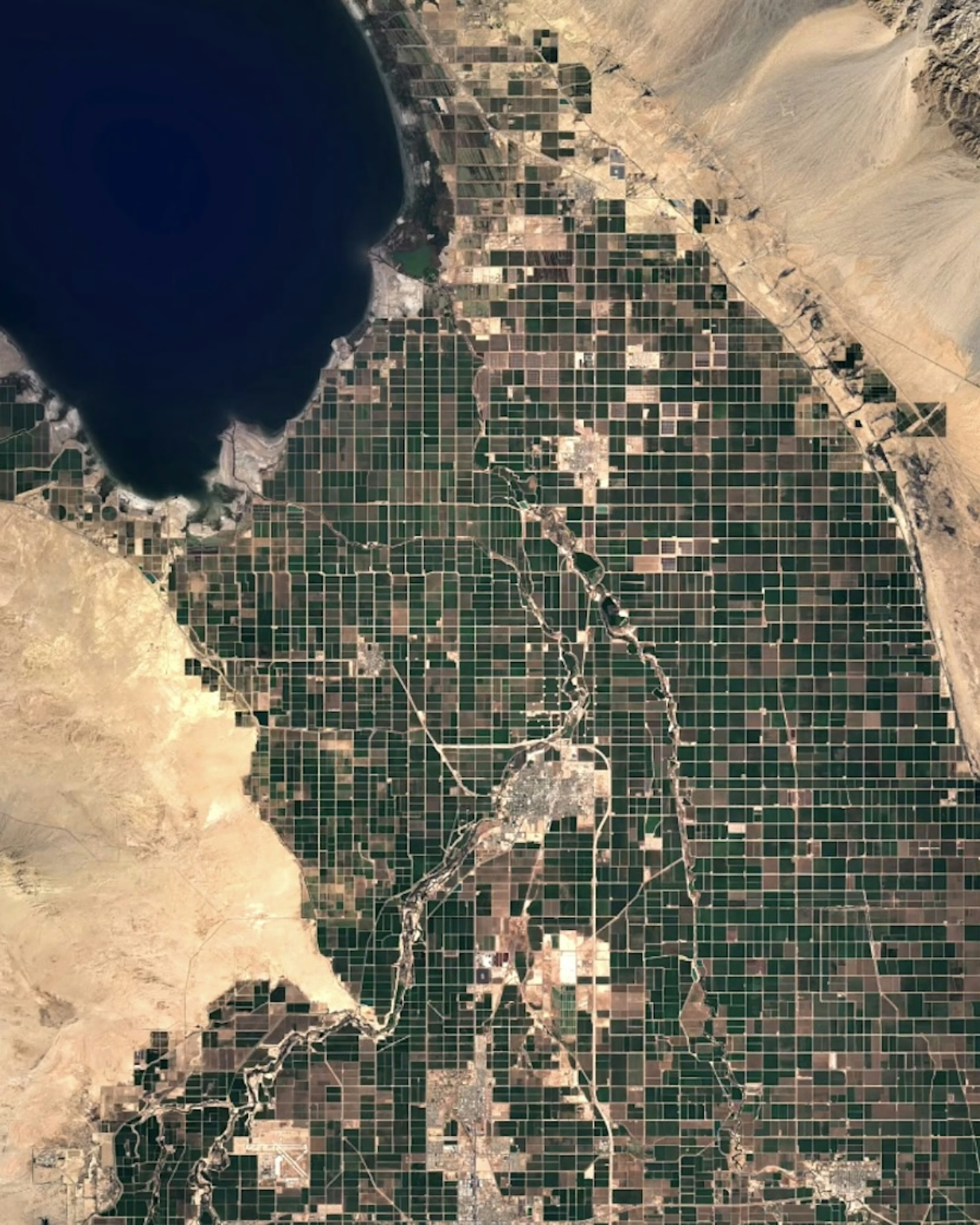
Salton Sea Agriculture
33.313056°,-115.834444° - NASA / Google Timelapse
The Salton Sea is a shallow, landlocked, highly saline lake at the southern end of California. For thousands of years, the Colorado River has flowed into the lake’s valley, or has been diverted around it, depositing silt and creating fertile farmland. Roughly 1,700 square miles (4,400 square kilometers) of agricultural development stretches from the Salton Sea to the US-Mexico border, growing a variety of crops like asparagus, squash, tomatoes, watermelons, and dates.
Stuyvesant Town
40.732000°,-73.978000° - Nearmap
Stuyvesant Town is a residential community on the east side of Manhattan in New York City. In total, combined with neighboring Peter Cooper Village, its 110 red brick buildings contain 11,250 apartments, providing homes for slightly more than 21,000 people. The development, commonly known as StuyTown, opened in 1942 and primarily housed veterans returning to the United States from World War II.
Dead Sea
31.500000°,35.500000° - Google Timelapse
The Dead Sea, which straddles the border between Israel and Jordan, has changed shape over the years. Its surface area has dropped from 410 square miles in 1930 to 234 square miles today (1,050-605 square km), causing it to split into two basins in 1979. Since then, its southern basin has been partitioned into a series of saltwater evaporation pans.
Xico Crater
19.259820°,-98.942070° - Maxar
The city of Xico, in the southeastern corner of Mexico City, surrounds a large volcanic crater. Known as Cerro de Xico, or “Hill of Xico,” the 1-kilometer-wide crater provides fertile soil and naturally protected farmland amid the ever-advancing sprawl of Mexico City. The Xico Crater and all of its surroundings were once submerged by Lake Chalco, until the 16th or 17th century when the lake began to be drained for agriculture and development.
Winnipeg
49.925864°,-97.108445° - Nearmap
The Red River winds through the north end of Winnipeg, Manitoba, Canada. Located near the longitudinal center of North America, Winnipeg is a railway and transportation hub known as the "Gateway to the West." It has a metropolitan population of nearly 840,000.
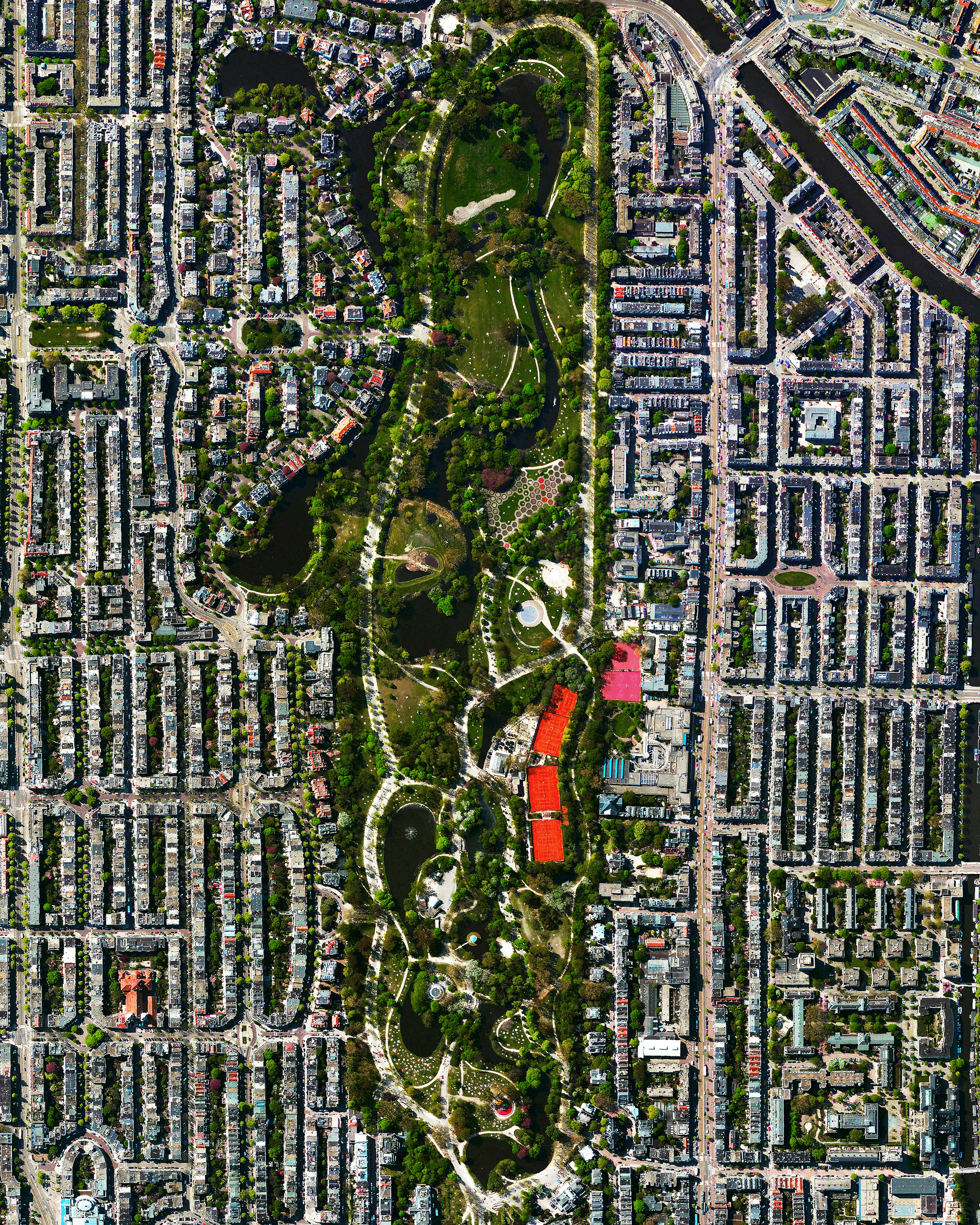
Vondelpark
52.358000°,4.868000° - Maxar
The Vondelpark is a public park in Amsterdam, Netherlands, which attracts more than 10 million visitors each year. In addition to ample green spaces and ponds, the Vondelpark contains an open-air theater, sculptures, athletic facilities, and numerous playgrounds. At 120 acres (47 hectares), it is the largest park in the city.
AAMI Park
-37.825278°,144.983889° - Nearmap
AAMI Park is an outdoor sports stadium in the central business district of Melbourne, Australia, constructed between 2007 and 2010. The 30,000-seat stadium features a geodesic dome roof with thousands of LED lights on its exterior, capable of displaying a variety of patters and images. Its rectangular playing surface allows it to host rugby, soccer and Australian rules football matches, as well as large concerts.
Zagros Mountains
30.267173°,53.577873° - Maxar
A dusting of snow accents the mountainous landscape of Fars Province in southwestern Iran. This region lies in the foothills of the Zagros Mountains, where peaks reach around 13,000 feet (4,000 m), winters are moderate to cold, and summers are mild. The Zagros are rich in limestone, and the mountains shown in this Overview likely contain the reddish-brown Asmari Limestone.
Mercedes Benz Stadium
33.755148°,-84.401215° - Nearmap
Mercedes-Benz Stadium is a 71,000-seat, multi-purpose stadium in Atlanta, Georgia, USA. Opened in 2017, it serves as the home field of the Atlanta Falcons of the National Football League and Atlanta United FC of Major League Soccer. The stadium's signature feature is its retractable roof, which features a "pinwheel" consisting of eight translucent, triangular panels.
Salina, Italy
38.565278°,14.833333° - Airbus Space
Salina is the second largest of the Aeolian Islands, a volcanic archipelago north of Sicily, Italy. Its 10 square miles (27 square km) of surface area are primarily composed of six volcanoes. Two of its most prominent peaks — Monte dei Porri (bottom) and Monte Fossa delle Felci (top) — are seen here. The island is home to approximately 2,600 people.
Antalya at Night
36.915451°,30.701941° - NASA
The city of Antalya, Türkiye at night, captured by an astronaut aboard the International Space Station. Located along the Mediterranean Sea, Antalya is the fifth most-populous city in Türkiye with over 2.6 million people in its metropolitan area. Amid the bright lights of the city, the outlines of the pentagonal Zeytinpark and of Antalya Airport are visible.
Valletta
35.898333°,14.512500° - Maxar
Valletta, capital city of Malta, is located on a peninsula between Marsamxett Harbor (top) and the Grand Harbor. It is the southernmost capital of Europe, and at just 0.24 square miles (0.61 sq km), it is the European Union's smallest capital city. Valletta is noted for its historic fortifications and its Baroque palaces, gardens and churches.
Northport Log Shipping
-35.836544°,174.484695° - Nearmap
Logs are loaded onto cargo ships at Northport in Marsden Point, New Zealand. Located at the head of Whangārei Harbour on the North Island, Northport handles various freight including logs, woodchips, veneer, coal, kiwifruit, cement and fertilizer. In 2021, the port handled 3.5 million tons of cargo, 2.8 million tons of which were log exports.
The Forbidden City
39.914722°,116.390556° - Maxar
The Forbidden City in Beijing, China, took 14 years to build (1406 to 1420) and more than 1 million workers were involved in its construction. The palace complex, which contains 9,999 rooms, is surrounded by walls that are 26 feet (8 meters) high and a 171-foot (52-meter) wide moat.
Gorgon LNG Plant
-20.790183°,115.448152° - Nearmap
The Gorgon Liquified Natural Gas (LNG) processing plant, located on Barrow Island off the coast of Western Australia. Connected to two underwater gas fields in one of the largest subsea installations in the world, the Gorgon plant can process 15.6 million tons of LNG per year. It contains two holding tanks with a combined 12.6 -million-cubic-foot capacity and about four times as much steel as the Sydney Harbour Bridges.
Fort Jefferson
24.628611°,-82.873205° - Nearmap
Fort Jefferson is a former U.S. military coastal fortress located in the lower Florida Keys. It is the largest brick masonry structure in the Western Hemisphere, made with more than 16 million bricks. Fort Jefferson is on Garden Key, the second-largest island in Dry Tortugas National Park.
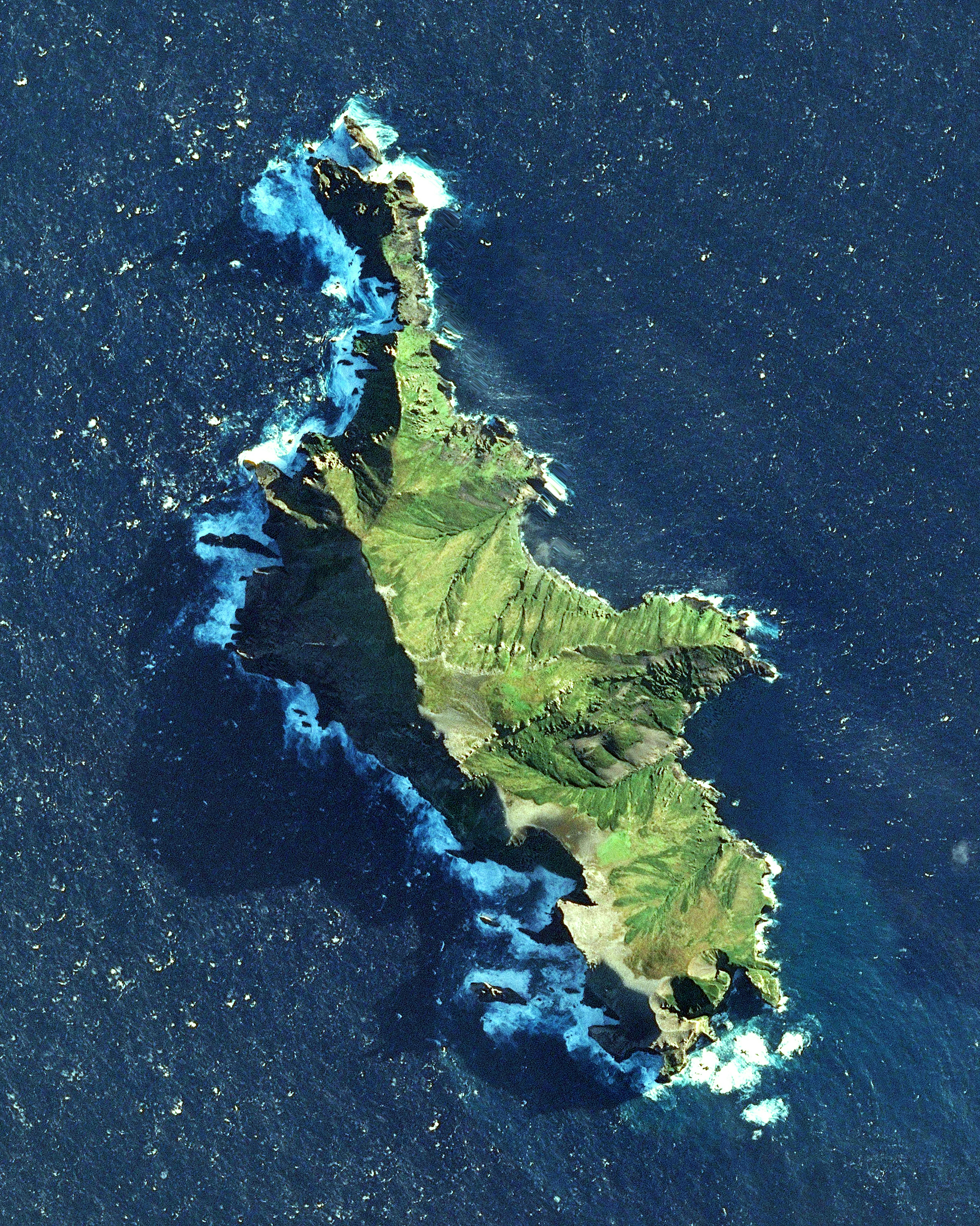
Île des Pingouins
-46.416667°,50.400000° - Airbus Space
Île des Pingouins, or Penguin Island, is an uninhabited island in the subantarctic Crozet Archipelago of the southern Indian Ocean. It is small — just 1 square mile (3 square km) — with coastal cliffs ranging from 164 to 984 feet (50-300 meters) tall, making it virtually inaccessible by sea. The island is an important nesting site for seabirds and has an exceptionally high density of avian residents, including a million pairs of macaroni penguins.
Moçâmedes Desert
-16.338405°,11.821245° - Maxar
Sand dunes meet the Atlantic Ocean in the Moçâmedes Desert of southwestern Angola. The desert, which extends about 275 miles (450 km) along the coast, receives less than 2 inches (50 mm) of rainfall annually and is almost entirely uninhabited. The topography of this region is characterised by shifting dunes fields, vast gravel plains, and rough mountains and cliffs.
